
Arosa Dolomites
| Arosa Dolomites | ||
|---|---|---|
 Arosa Dolomites, view from Prätsch above Arosa |
||
| Highest peak | Erzhorn ( 2924 m above sea level ) | |
| location | Canton of Graubünden , Switzerland | |
| part of | Plessur Alps | |
|
||
| Coordinates | 772 950 / 181963 | |
| rock | Main dolomite | |
| Age of the rock | 210 million years | |

The Arosa Dolomites are a series of mountain peaks made of main dolomite near Arosa in the Plessur Alps , Graubünden , Switzerland . Its highest point is the Erzhorn ( 2924 m ).
location
The mountain range is located between the valley Schanfigg / Welschtobel and Landwassertal in the Strelakette and Erzhorn- Lenzer Horn chain.
Outline and summit
From the Strela Pass , the two parallel rows of peaks of the Strela range can be seen in a south-westerly direction. The northwestern row runs over Strela, Chüpfenflue , Mederger Flue, Tiejer Flue , Furggahörner, Schiesshorn to the Leidflue at the entrance of the Welschtobel; it forms the northeastern part of the Arosa Dolomites. These are continued on the opposite side of the Welschtobel from Schafrügg via Schaftälli-, Älplisee- and Gamschtällihorn to the Erzhorn at the southwest end. Geologically, the Aroser - and Parpaner Weisshorn as well as the Schiahorn and the Weissflue are counted among the Aroser Dolomites.
nature
The Arosa Dolomites are the main thrust of the Eastern Alpine over the Pennine units and lie directly above the Arosa scale zone. They have similar characteristics to certain mountains in the Montafon ( Drei Schwestern , Schesaplana or Zimba ). The peaks are mostly without vegetation, sloping towards the southeast in crags and scree slopes, towards the northwest in articulated rock faces. The rocks are only moderately difficult to climb, but brittle and in many places covered with debris.
Emergence
Like the other dolomite areas, the Arosa Dolomites were formed on flat tropical coasts in the tidal area. They formed around 210 million years ago in the Triassic period . They belong to the deposits on the crystalline basement of the Silvretta cover from the African continental margin . At that time, the primary continent of Pangea began to expand , as a result of which the earth's crust sank widely and the Ur- Tethys Sea could slowly expand from the east into the area of the later Alps. For many millions of years, flat sea conditions with a tropical climate prevailed, and dolomite rocks were formed with great thickness. In contrast to the Italian Dolomites , for example , where the same rocks occur in an even greater thickness and mostly in a horizontal position, the rocks of the Arosa Dolomites are folded , sheared and broken by the transport of the roof ; therefore, they only form solid climbing rocks in exceptional cases.
photos

Northeastern part (Strela-Schiesshorn)

Southwestern part (Schafrügg-Erzhorn)

The Aroser Dolomites from the Aroser Rothorn
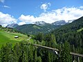
Chüpfenflue , Medergerflue, Tiejer Flue and Furggahorn above the Gründjitobel viaduct
View from Scheidegg in northeast direction

Arosa Dolomites from Hörnliexpress seen

View towards Chüpfenflue


.jpg)
literature
- Jürg Meyer: Geology and Rocks, in: Manfred Hunziker: Ringelspitz / Arosa / Rätikon, Alpine Tours / Bündner Alpen , Verlag des SAC 2010, ISBN 978-3-85902-313-0 , p. 31 ff.
- SAC Club Guide, Bündner Alpen 1, Tamina and Plessur Mountains , Verlag des SAC, 4th edition 1988, p. 27 ff.