
Strela chain
| Strela chain | ||
|---|---|---|
 View from the Arosa Schwellisee to the northwestern Strela range |
||
| Highest peak | Guggernellgrat ( 2810 m above sea level ) | |
| location | Canton of Graubünden , Switzerland | |
| part of | Plessur Alps | |
|
||
| Coordinates | 774 996 / 182424 | |
| rock | Aroser dolomite & crystalline ( Silvretta ceiling ) | |

The Strela chain is a mountain range of the Plessur Alps in Graubünden , Switzerland . Its highest point is the Guggernellgrat ( 2810 m ). The name “Strela” is derived from the Latin “striga” or the Romansh “stria” (witch).
location
The mountain range lies between the valley communities of Schanfigg / Welschtobel and Landwassertal with the holiday resorts of Arosa and Davos .
Outline and major summits
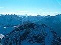
Two parallel rows of peaks can be seen from the Strela Pass in the northeast to the Furcletta in the southwest. The north-western series of peaks, which form part of the Arosa Dolomites , runs over Strela ( 2636 m ), Chüpfenflue ( 2658 m ), Mederger Flue ( 2674 m ), Tiejer Flue ( 2781 m ), Schiesshorn ( 2605 m ), Leidflue ( 2560 m) ); the south-eastern one as part of the Silvretta blanket above Chörbsch Horn ( 2651 m ), Amselflue ( 2781 m ), Valbellahorn ( 2763 m ), Guggernell ridge . From the Strelapass to Maienfelder (Aroser) Furgga the north-western series of peaks dominates, then the south-eastern one. The watershed changes several times from one row to the other, for example at Latschüelfurgga , Schwifurgga and Maienfelder Furgga .
landscape
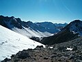
The alpine meadows of Altein Tiefenberg and Alteinsee are embedded in the hollow between the two rows. From there, via Murterus (Romansh: Martiroz) there is an interesting access to the Ramozhütte SAC in the Welschtobel. On the Landwasser Valley side there are extensive alpine areas above a forest zone, from which the peaks can be reached relatively easily. The higher peaks are mostly without vegetation, sloping towards the south-east in crags and scree slopes, towards the north-west in articulated rock walls. The rocks are only moderately difficult to climb, but brittle and in many places covered with debris. The higher peaks are therefore not overrun by mountain hikers, while the numerous pass crossings between Schanfigg and Landwassertal with marked hiking trails are very popular.
photos

Part of the northwestern Strela range, seen from Arosa. In the middle the Maienfelder Furgga
Strela chain, southwestern part

Strela chain, northeastern part
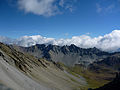
In the middle of the Strela chain, view to the southwest

View from Sandhubel towards Altein Tiefenberg

Mederger Flue / Strela chain
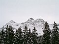
Winter impression
Guggernellgrat, highest point of the chain


swell
- Manfred Hunziker: Ringelspitz / Arosa / Rätikon, Alpine Tours / Bündner Alpen , Verlag des SAC 2010, ISBN 978-3-85902-313-0 , pp. 341–384.
- SAC Club Guide, Bündner Alpen 1, Tamina and Plessur Mountains , Verlag des SAC, 4th edition 1988, p. 31, 282 ff.
- Fritz Maron: From mountain farming village to world health resort Arosa , Verlag F. Schuler, Chur 1934, p. 13 f.
- SAC Club Guide, Bündner Alpen 1, Tamina and Plessur Mountains , Central-Comité des SAC, 2nd edition 1925, p. 274 ff.
Individual evidence
- Andrea Schorta: How the mountain got its name , Terra Grischuna Verlag, 3rd edition, Chur 1999, p. 137.