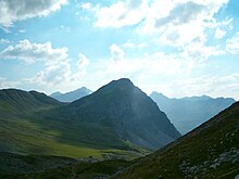
Shooting horn
| Shooting horn | ||
|---|---|---|
|
Schiesshorn north face |
||
| height | 2605 m above sea level M. | |
| location | Canton of Graubünden ( Switzerland ) | |
| Mountains | Plessur Alps | |
| Dominance | 1.23 km → Wasmengrat | |
| Notch height | 178 m ↓ unnamed notch | |
| Coordinates | 772.95 thousand / 181963 | |
|
|
||
| rock | dolomite | |
| Age of the rock | approx. 210 million years | |
| Development | Mountain hiking trail | |
The Schiesshorn at 2605 m above sea level. M. is a mountain near Arosa in the canton of Graubünden in Switzerland .
Location and description
The Schiesshorn is one of the central peaks of the Strela range in the Plessur Alps . It is located slightly in front of the main chain and, with a 700 m high steep face towards Arosa, gives it an imposing shape. Neighboring peaks are the Furggahörner in the northeast and the Leidflue in the southwest. The Walsers who used to settle in Arosa also called the mountain Chalchgrind . The mountain is one of the Arosa Dolomites , which are the main thrust of the Eastern Alpine over the Penninic units directly above the Arosa scale zone and extend in a north-easterly direction to the Chüpfenfluh on the Strela Pass . The southwest end of the Arosa Dolomites is located in the area of the imaginary line Erzhorn - Murterus -Leidflue in the Welschtobel .
From the following locations (distance and direction) to the Schiesshorn: Innerarosa Bergkirchli 1895 m, (3,456 km, 108 °), Arosa train station 1739 m, (2,597 km, 134 °), Litzirüti 1452 m, (3.09 km, 178 ° ), Langwies 1377 m, (6,054 km, 186 °).
Neighboring peaks (distance, direction): Furggahorn, 2727 m (1974 m, 57 °), Amselflue , 2781 m (1997 m, 97 °), Wasmengrat 2701 m (1488 m, 113 °), Amselegg 2509 m, (633 m , 141 °), Strel, 2674 m (1911 m, 150 °), Valbellahorn 2764 m (2.962 km, 181 °), Sandhubel 2764 m (3.249 km, 204 °), Leidflue 2560 m (2.845 km, 220 °), Erzhorn 2924 m (6.137 km, 243 °), Aroser Weisshorn 2653 m (5.554 km, 296 °), Hochwang 2533 m (13.131 km, 334 °), Mattjisch Horn 2461 m (9.551 km, 8 °).
Routes to the summit
The Schiesshorn can be easily reached from the Arosa reservoir and from the Grünsee via Furggatobel-Obersäss-Schiesshornfurgga as well as via Altein Tiefenberg -Schiesshornfurgga on marked mountain hiking trails and is visited accordingly often (difficulty T4 ). The ski touring route also leads through the Furggatobel.
The massive north face was first climbed in 1901 by Henry Hoek . Different variants are possible, which lead over long distances through steep rubble slopes and rubble-filled couloirs (difficulty ZS ; time required 4 hours).
The summit offers the visitor a not very wide panorama, but a beautiful deep view of Arosa and the surrounding area.
Ascent on the Swiss National Day
On the evening of August 1st ( Swiss Federal Day ), members of the Swiss Alpine Club (SAC ) climb the north face, marking their route for the audience with burning torches. At the summit also is an after dusk bonfires kindled.
Flora + fauna
For the first time in recent times, the rearing of a young golden eagle could be observed on the Schiesshorn in the summer of 2013 .
cards
- National map of Switzerland 1: 25,000, sheet 1196 Arosa, sheet 1316 Filisur ,
- National map of Switzerland 1: 50,000, sheet 5002 Chur- Arosa- Davos .
swell
- Hans Danuser : Arosa place and field names with inclusion of the Welschtobel and some areas near the border in neighboring communities, self-published Danuser, Arosa 2011, ISBN 3-905342-49-9 , p. 32 f.
- Manfred Hunziker: Ringelspitz / Arosa / Rätikon, Alpine Touren / Bündner Alpen , Verlag des SAC 2010, ISBN 978-3-85902-313-0 , p. 364.
- SAC Club Guide, Bündner Alpen 1, Tamina and Plessur Mountains , Verlag des SAC, 4th edition 1988, p. 301 f.
Web links
- Tour suggestions Schiesshorn
- Panoramas from the Schiesshorn: valley view , chain of peaks
Individual evidence
- ↑ Video clip hike to the Schiesshorn with a view of the summit (1957)
- ↑ Aroser Zeitung of September 20, 2013, p. 14 f.


