
Chüpfenflue
| Chüpfenflue | ||
|---|---|---|
 The Chüpfenflue as seen from Sapün / Schmitten . |
||
| height | 2658 m above sea level M. | |
| location | Canton of Graubünden , Switzerland | |
| Mountains | Plural pen | |
| Dominance | 2.143 km → Schiahorn | |
| Notch height | 249 m ↓ Latschüelfurgga | |
| Coordinates | 778 384 / 186673 | |
|
||
| rock | dolomite | |
| Normal way | Over the southeast ridge | |
 North side of the Chüpfenflue (right) and Strela (left), taken from the main valley. |
||
 Steinmann on the Chüpfenflue. |
||

The Chüpfenflue (from the Swiss German word Chüpfe for mountain top or mountain peak and Fluh for rocks , ledge , rock face , rock peaks ) is a mountain between the tourist destinations Davos and Arosa in the canton of Graubünden in Switzerland at an altitude of 2658 m above sea level. M.
Location and surroundings
The Chüpfenflue belongs to the Strela chain , a mountain range of the plural Alps . It is also one of the Arosa Dolomites . As with the other Arosa Dolomites, its summit is devoid of vegetation, sloping towards the northwest (towards Arosa ) in crags and scree slopes, and towards the southeast (towards Davos ) in structured rock faces. The municipal boundary of the municipalities of Davos and Arosa runs along it. The Chüpfenflue is bordered in the north by the main valley and in the west by the Chüpfer Tälli. Both valleys belong to the Sapün high valley , a side valley of the Schanfigg . The southeast ridge separates the troughs from Vorder- and Hinter Latschüel (both Landwassertal ).
The neighboring peaks include the Haupter Horn in the north, the Strela in the northeast, the Wannengrat and the Chörbsch Horn in the south, and the Mederger Flue in the southwest.
The valley locations are Davos, Langwies and Arosa. Frequent starting points are the Schatzalp and Medergen .
Routes to the summit
Nothing is known from alpine literature about ascents through the north and west faces, although there are undoubtedly not very difficult ( WS ) routes to be found in these faces.

North-east ridge, seen from the Strela .
|
Over the southeast ridge
Over the northeast ridge |


panorama

gallery

Looking west to Arosa .

View down to Usserhaupt (left) and Innerhaupt (right).

View down to the Dörfji Sapün .

View to the northeast to Weissfluh (left) and Weissfluhjoch (right).
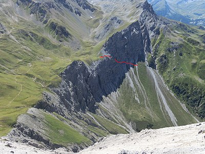
View from the summit down to the step. The hiking trail from Langwies / Arosa to Latschüelfurgga runs straight through the rocks (marked in red).
.jpg)


.jpg)
literature
- Manfred Hunziker: Ringelspitz / Arosa / Rätikon, Alpine Touren / Bündner Alpen , Verlag des SAC 2010, ISBN 978-3-85902-313-0 , p. 383.
- Bernard Condrau, Manfred Hunziker: Club guide, Bündner Alpen, Volume I (Tamina and Plessur Mountains). 4th edition. Verlag des SAC, 1988, ISBN 3-85902-048-X , p. 283.
- Fabian Lippuner, David Coulin: Alpine hiking / summit destinations, Graubünden North. Verlag des SAC, 2013, ISBN 978-3-85902-341-3 , pp. 116–119.
- National map of Switzerland, sheet 1196 Arosa, 1: 25000, Federal Office of Topography, 2011 edition.
- National map of Switzerland, sheet 1197 Davos, 1: 25000, Federal Office of Topography, 2011 edition.
Web links
Individual evidence
- ↑ Andrea Schorta: How the mountain got its name . Small Rhaetian name book with two and a half thousand geographical names of Graubünden. Terra Grischuna Verlag, Chur and Bottmingen / Basel 1988, ISBN 3-7298-1047-2 , p. 78 .
- ↑ Andrea Schorta: How the mountain got its name . Small Rhaetian name book with two and a half thousand geographical names of Graubünden. Terra Grischuna Verlag, Chur and Bottmingen / Basel 1988, ISBN 3-7298-1047-2 , p. 87 .