
Weissfluhjoch
| Weissfluhjoch | ||
|---|---|---|
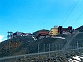
 The summit with the Parsennbahn station (center), the research institute (right) and the restaurant (left). |
||
| height | 2693 m above sea level M. | |
| location | Graubünden , Switzerland | |
| Mountains | Plural pen | |
| Dominance | 0.52 km → Weissflue | |
| Notch height | 64 m ↓ Wasserscheidi | |
| Coordinates | 780 615 / 189636 | |
|
||
| Development | Various cable cars of the Davos Klosters Bergbahnen | |
| particularities | Former research institute and measuring field of the WSL Institute for Snow and Avalanche Research SLF . | |
 Parsenn ski area , taken from the Gotschnagrat . In the middle of the picture the Weissflue , to the left the Weissfluhjoch. |
||

The Weissfluhjoch is 2693 m above sea level. M. high mountain in the plural Alps in Switzerland . It is located in the north-west of Davos in the triangle of the Landwassertal , Prättigau and Schanfigg regions and is the local mountain of the Alpine city. The Parsennbahn has been opening up the Weissfluhjoch for tourism since 1932 .
Location and surroundings

The Weissfluhjoch belongs to the Weissfluh group, a subgroup of the plural pen. The mountain consists of two peaks, the 2693 m above sea level. M. high east summit and the 2686 m above sea level. M. high west summit. The municipal boundaries between Davos, Klosters-Serneus and Arosa (formerly Langwies ) meet on the western summit . The main peak is in the municipal area of Davos and Klosters-Serneus. The Weissfluhjoch is bordered in the southeast by the Dorftälli, in the northeast by the Meierhofer Tälli (both Landwassertal), in the northwest by the Obersäßälli (Prättigau) and in the southwest by the Haupter Tälli ( Sapün im Schanfigg).
The neighboring peaks include the Schwarzhorn in the north, the Totalphorn in the northeast, the Salezer Horn in the southeast, the Gross Schiahorn in the south, the Haupter Horn in the southwest and the Weissflue in the west. Between the Weissfluhjoch and the Weissflue, the Schanfigger Höhenweg leads from the Strelapass to the Casannapass .
Touristic
|
The Weissfluhjoch is located in the center of the Parsenn ski area of the Davos Klosters Bergbahnen . Seven cable cars end at the summit :
|

There is a mountain restaurant on the summit, consisting of a self-service restaurant, the full-service panorama restaurant, a house bar and a viewing terrace. In the same building there is a sports shop with a test center, rental, depot and service. In the building to the north is the operations center of the parseing service, which ensures the rescue service for the two ski areas Parsenn and Pischa .

North of the Weissfluhjoch, at 2620 m above sea level. M. an igloo village is built every year . For this purpose, 3 to 5 meter large balloons are inflated and snowed in with artificial snow . The balloons are then removed again and the interior expanded. The igloos are ready for occupancy from the end of December. You can choose between a standard igloo for six people and a romantic igloo for two people. In the igloo village there is a warm whirlpool and a sauna.
The Weissfluhjoch is also often visited in summer. It is the starting point for many hikes, bike tours and downhill routes as well as a starting point for paragliders .
Snow and avalanche research

The former institute building of the WSL Institute for Snow and Avalanche Research SLF stands on the summit . As early as 1936, the first laboratory was set up to investigate snow metamorphosis and avalanche formation on the Weissfluhjoch. At that time, the Parsennbahn provided a wooden shack and a workroom. The wooden barracks were snowed in every winter and thus fulfilled their function as a natural cold laboratory. In 1942 the Federal Institute for Snow and Avalanche Research, Davos-Weissfluhjoch was founded and the first institute building on the Weissfluhjoch was moved into. The first refrigeration laboratories were put into operation in 1944.
In 1945, responsibility for avalanche warning was transferred from the Swiss Army to the SLF. An avalanche warning room was set up in the institute building, from which the avalanche bulletin was first broadcast weekly and later daily via radio and press. With these daily avalanche bulletins during the midday news , the SLF and with it the Weissfluhjoch became well known among the population throughout Switzerland. In 1956 a snow slide was built next to the institute building. The experiments with the snow slide provided information about the flow behavior of snow, about its pressure effect when hitting solid obstacles and about the braking effect of structured obstacles. In the avalanche winter of 1968, the Davos region was hit particularly hard by snow. The institute was isolated for three weeks. In 1996 the newly built institute building on Flüelastrasse in Davos Dorf became the headquarters of the SLF. The former institute building on Weissfluhjoch was sold to Bergbahnen Davos Klosters AG in October 2019.

About 500 m southeast of the Weissfluhjoch, at ( 2540 m ) lies the Weissfluhjoch test field (5WJ). The weather and snow conditions have been observed here every day since autumn 1936. Accessibility and the numerous avalanche slopes in the area contributed to the fact that many researchers were able to carry out countless decisive experiments and studies on snow mechanics, snow metamorphosis, snow characterization and measurement methods on the test field. They also tested prototypes of instruments , calibrated remote sensing products or used the data from the test field to compare their snow cover models with models from other researchers. The Weissfluhjoch test field is now the only place in the world at this altitude from which daily measurements of snow depth and fresh snow have been available for over 80 years. The test field has achieved worldwide recognition among researchers. The current snow and weather data can be viewed on the SLF website.

Former avalanche warning room in the former institute building.
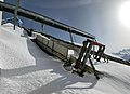
Snow slide of the SLF.
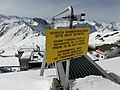
Sign on the roof of the former institute building.

The test field southeast of the Weissfluhjoch.

Researchers on the test field.


climate
The Weissfluhjoch is located in the moderate climatic zone . The individual seasons are very distinctive. On average it rains about 118 mm per month and 1411 mm per year. In the month with the most rainfall, August, it rains twice as much as in the month with the least rainfall, December. On average, more than one millimeter of precipitation can be expected on 148 days a year.
The annual mean temperature is around -1.9 ° C. The warmest month is August with a monthly mean temperature of 6 ° C. On average, there are no summer days with temperatures of at least 25 ° C per year, and accordingly no hot days with temperatures above 30 ° C. In winter, the average daily mean temperatures are well below freezing point . The coldest month is February with an average temperature of −8.7 ° C. Long-term mean values show 262 frost days (minimum temperature <0 ° C) and 168 ice days (maximum temperature <0 ° C) per year for the Weissfluhjoch .
The Weissfluhjoch has an average of 1782 hours of sunshine per year, which means that 42% of the maximum possible sunshine duration is achieved. There are an average of 97 bright days (days with more than 80% sunshine) and 136.8 cloudy days (days with less than 20% sunshine) on the Weissfluhjoch.
The mean wind speed in the measurement period from 1981 to 1990 was 4.8 m / s, with winds from north-westerly and southerly directions predominating. The highest mean wind speeds are reached with northwest wind.
Every year there is 980.2 cm of fresh snow on Weissfluhjoch, with most snowfall in January (137.8 cm) and the least in August (15.1 cm). There is at least 1 cm of fresh snow on 118.6 days per year, with March being the month with the most new snow days (15.6 days). There are no months in the year with an average of 0 days of fresh snow. The fewest days of fresh snow are in August (2.1 days). On 277.6 days a year there is an average of more than 1 cm of snow on the Weissfluhjoch. Even in August there is an average of 2.5 days of snow. The following snow data are also known from long-term measurements by the WSL Institute for Snow and Avalanche Research SLF :
- 75% of the precipitation falls in the form of snow.
- The highest snow depth ever measured was 3.66 m (March 9, 1945).
- The depth of snow on January 1st varies between 38 cm (1949) and 2.22 m (1975).
- On average, there is snow on the Weissfluhjoch from October 18 (extreme: September 6, 1984/25 November 1983) to July 9 (extreme: June 3, 1947/ August 15, 1983).
- At this altitude, climate change has not yet had any impact on the winter snowpack.
- At least one avalanche was observed in the vicinity on 34% of all days, none on 46% and no observation possible on 20% of the days.
| Weissfluhjoch 1981-2010 | ||||||||||||||||||||||||||||||||||||||||||||||||
|---|---|---|---|---|---|---|---|---|---|---|---|---|---|---|---|---|---|---|---|---|---|---|---|---|---|---|---|---|---|---|---|---|---|---|---|---|---|---|---|---|---|---|---|---|---|---|---|---|
| Climate diagram | ||||||||||||||||||||||||||||||||||||||||||||||||
| ||||||||||||||||||||||||||||||||||||||||||||||||
|
Average monthly temperatures and precipitation for Weissfluhjoch 1981–2010
Source: Meteoschweiz
|
||||||||||||||||||||||||||||||||||||||||||||||||||||||||||||||||||||||||||||||||||||||||||||||||||||||||||||||||||||||||||||||||||||||||||||||||||||||||||||||||||||||||||||||||||||
Routes to the summit

The Weissfluhjoch is not only the destination, but also the starting point for numerous hikes. That is why the following shows not only the times for the routes to the summit, but also for the way back. The hiking trails are well marked in the area and marked on hiking maps.
Through the Dorftälli
- Starting point: Davos ( 1560 m ) or Höhenweg ( 2218 m )
- Difficulty: T2 , B , marked as a white-red-white hiking trail .
- Time required: 1¼ hours from the Höhenweg (¾ hours back), or 3½ hours from Davos (2¼ hours back)
- Alternative: From Davos via Meierhofer Berg to the Höhenweg (+ ¼ hour)
Through the Meierhofer Tälli
- Starting point: Davos ( 1560 m ) or Wolfgang ( 1631 m )
- Via: Meierhofer Berg, Meierhofer Tälli, Totalpsee, Wasserscheidi
- Difficulty: T2 , B , marked as a white-red-white hiking trail .
- Time required: 3½ hours (2½ hours back)
- Alternative: via Totalp + ½ hour (+ ¼ hour back)
Via Parsennhütte
- Starting point: Gotschnagrat ( 2281 m ) or Wolfgang ( 1631 m )
- Via: Parsennhütte, Totalpsee, Wasserscheidi
- Difficulty: T1 , B , marked as a white-red-white hiking trail .
- Time required: 2 hours from Gotschnagrat (1¾ hours back) or 3¼ hours from Wolfgang (2¼ hours back)
- Alternative: via Parsennfurgga, Obersäßälli (+0 hours)
Through the Obersasställi
- Starting point: Langwies ( 1377 m ), Klosters ( 1206 m ) or Serneus ( 995 m )
- Via: Way of the Cross
- Difficulty: T2 , B , marked as a white-red-white hiking trail .
- Time required: 5 hours from Langwies (3½ hours back), 5½ hours from Klosters (4 hours back) or 5½ hours from Serneus (3¾ hours back)
Through the main valley
- Starting point: Langwies ( 1377 m ), Höhenweg ( 2218 m ), Schatzalp ( 1861 m ) or Davos ( 1560 m )
- Via: Strelapass ( 2352 m ), Felsenweg
- Difficulty: T2 , B , marked as a white-red-white hiking trail .
- Time required: 4¾ hours from Langwies (3½ hours back), 2¾ hours from the Höhenweg (2¼ hours back), 2¾ hours from Schatzalp (1¾ hours back) or 4 hours from Davos (2¾ hours back)
panorama


gallery

Weissflue (left), Weissfluhjoch (right) and the summit lift in between, taken from the Chüpfenflue

Weissfluhjoch mountain restaurant with terrace, self-service restaurant (below) and panorama restaurant (above)

The Parsennbahn before the renovation in 2010

The new Parsennbahn in the Weissfluhjoch mountain station
The cable car stations at Weissfluhjoch, view from the north

View to the southeast to the Bergüner Stöcken with Piz Ela (left), Tinzenhorn (middle) and Piz Mitgel (right)


literature
- Manfred Hunziker: Ringelspitz / Arosa / Rätikon . From the Pass dil Segnas to the Schlappiner Joch. ( Alpine tours - Bündner Alps ). Verlag des SAC, Bern 2010, ISBN 978-3-85902-313-0 , p. 393.
- Bernard Condrau, Manfred Hunziker: Club guide, Bündner Alps. Volume I: Tamina and Plessur Mountains. 4th edition. Verlag des SAC, 1988, ISBN 3-85902-048-X , p. 271.
- National map of Switzerland, sheet 1197 Davos, 1: 25000, Federal Office of Topography, 2011 edition.
Web links
- Panorama from the Weissfluhjoch
- Tour reports and photographs on hikr
- Homepage of the WSL Institute for Snow and Avalanche Research SLF
- Homepage of the Parsenn ski area
Individual evidence
- ↑ Ski lifts Parsenn (Davos-Klosters) . Website of the Skiresort Service International GmbH. Retrieved September 5, 2014.
- ↑ WFJ . Website of the Weissfluhjoch mountain restaurant. Retrieved September 5, 2014.
- ^ Sportshop Weissfluhjoch ( Memento from May 22, 2015 in the Internet Archive ). Andrist Sport + Mode website. Retrieved September 5, 2014.
- ↑ DAVOS-KLOSTERS ( Memento from September 19, 2012 in the Internet Archive ). Iglu-Dorf GmbH website. Retrieved September 5, 2014.
- ↑ Parsenn summer . Destination Davos Klosters website. Retrieved September 5, 2014.
- ^ SLF history ( memento of March 18, 2012 in the Internet Archive ). Website of the WSL Institute for Snow and Avalanche Research SLF. Retrieved September 5, 2014.
- ↑ Experiments on the snow slide at Weissfluhjoch Davos ( Memento from September 5, 2014 in the web archive archive.today ). Website of the WSL Institute for Snow and Avalanche Research SLF. Retrieved September 5, 2014.
- ↑ Former SLF institute building on Weissfluhjoch sold to the mountain railways. Retrieved November 29, 2019 .
- ↑ a b Weissfluhjoch test field ( Memento from May 12, 2010 in the Internet Archive ). Website of the WSL Institute for Snow and Avalanche Research SLF. Retrieved September 5, 2014.
- ↑ Snow info> Measured values> Wind and temperature data> North and Central Grisons ( Memento from July 14, 2014 in the Internet Archive ). Website of the WSL Institute for Snow and Avalanche Research. Retrieved September 5, 2014.
- ↑ MeteoSwiss. (PDF) Retrieved July 3, 2015 .