
Piz Ela
| Piz Ela | ||
|---|---|---|
 Piz Ela, recorded by Pizza Grossa |
||
| height | 3338.7 m above sea level M. | |
| location | Graubünden , Switzerland | |
| Mountains | Albula Alps | |
| Dominance | 6.36 km → Piz d'Err | |
| Notch height | 509 m ↓ Fuorcla da Chitta | |
| Coordinates | 773 839 / 163 701 | |
|
||
| rock | dolomite | |
| First ascent | July 17, 1865 by Alex Flury, Peter Jenny and Georg Jenny | |
| Normal way | Over the west ridge | |
| particularities | Ela hole (Fora digl Ela) | |

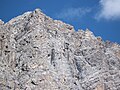
The Piz Ela (also Piz Aela , from the Rhaeto-Romanic ela, ala from the Latin ala for 'wing') is 3338.7 m above sea level. M. high mountain in the Albula Alps in the canton of Graubünden between Bergün and Savognin in Switzerland . It has the shape of a huge cathedral with a wide arched dome. But despite this broad dome shape, it is a narrow ridge crowned with a sharp edge , which is best seen when looking at the mountain from the southeast. The first ascent took place on July 17, 1865 by Alex Flury, Peter Jenny and Georg Jenny. After the Marmolada ( Dolomites ) is the summit of the second highest mountain peaks of dolomite and thus the highest Dolomite peaks of the Swiss Alps . About 30 m below the southeast ridge there is an opening in the rock, the Ela-Loch.
Thanks to its dominance , especially to the west, Piz Ela offers an exceptional view of the Bernese and Valais Alps (e.g. of the Eiger , Mönch , Finsteraarhorn , Aletschhorn or the Joderhorn, which is around 150 km away ).
The Ela hut at 2252 m above sea level. M. serves as a base for an ascent, which is relatively demanding on all routes. The mountain is in the middle of Parc Ela , a 600 square kilometer nature park opened in 2006 .
In Hauptdolomit traces were of prosauropods and sauropods discovered. They date from the late Triassic period and are around 210 million years old.
Location and surroundings
The Piz Ela is the highest elevation of the Bergüner Stocks , a subgroup of the Albula Alps . The Piz Ela separates the Albula valley in the east from the Oberhalbstein in the west . The municipal boundaries of Bergün Filisur and Surses meet at the summit .
The neighboring peaks of Piz Ela include Piz d'Uglix , Piz Spadlatscha , Piz digl Barba Peder , Piz Rugnux , Tschimas da Tschitta , Piz Val Lunga , Pizza Grossa and Tinzenhorn .
To the east of the summit, the otherwise pronounced Felsberg carries a glacier , the Vadret digl Ela .
Valley locations are Bergün and Filisur in the Albula Valley, and Savognin and Tinizong in Oberhalbstein. A frequent starting point for tours is the Ela hut in the lonely Val Spadlatscha .
Ela hole (Fora digl Ela)

About 30 m below the southeast ridge, 160 m southeast of the summit, about 3270 m above sea level. M. is the Ela-Loch ( Romansh Fora digl Ela ), an approx. 2.5 m high, 5 to 6 m wide and 3 m deep opening in the rock. Twice a year (between October 15th and 20th at 3–4pm CEST , and between February 22nd and 27th at 2–3pm CET ) the sun shines through the hole onto the village of Bergün .
Likewise, on August 10th, the sun shines early in the morning through the hole onto the Maiensäss Manziel in the former municipality of Riom . This event is so special because August 10th is Laurentius Day and the Church of Riom is under the patronage of St. Lawrence of Rome .
The forecast for the hole created when the devil after an argument, Eulenspiegel a stone was thrown at. The stone missed Eulenspiegel and instead hit Piz Ela. The argument was about the fact that Eulenspiegel had asked the devil in a potato field whether he wanted the fruit above or below the ground. When the devil decided on the above, Eulenspiegel laughed at him. On the corn field, Eulenspiegel asked the same question, but this time the devil chose the fruits in the earth.
Ela round trip
A well-known hike or ski tour for less experienced mountaineers is the Ela round tour. The two-day tour begins in Bergün ( 1367 m ) or Filisur ( 1032 m ) and leads to the Ela Hut ( 2252 m ) on the first day . On the second day the tour leads over the Pass d'Ela ( 2724 m ), past the mountain lakes Lai Mort and Lai Grond to Fuorcla da Tschitta ( 2830 m ) and then to Preda ( 1789 m ).
Duration: 3½ - 4½ hours on the first and 5 hours on the second day.
Difficulty: B
Routes to the summit
The alpine road from Tinizong into the Val d'Err is closed to general motor vehicle traffic. However, a hiking bus runs from Savognin to Penza on Tuesdays and Fridays.
Over the west ridge
Normal route
- Starting point: Ela hut ( 2252 m )
- Difficulty: ZS
- Time required: 4–5 hours
Over the northwest ridge
- Starting point: Ela hut ( 2252 m )
- Difficulty: ZS
- Time required: 6–8 hours
Through the northeast face
Long and arduous path (2000 m difference in altitude)
- Starting point: Bergün ( 1367 m )
- Difficulty: ZS
- Time required: 6–7 hours
Over the southeast ridge
Particularly nice climbing. The Ela hole located in the steepest section gives an idea of the narrowness of the ridge, as the rock is broken here, although about 30 m below the edge.
- Starting point: Bergün ( 1367 m ), Naz ( 1747 m ), Tinizong ( 1232 m ) or Ela hut ( 2252 m )
- Difficulty: ZS
- Time required: 8–9 hours from Bergün, 6½-8 hours from Naz, 8–9 hours from Tinizong or 7–8 hours from the Ela hut
Over the southwest pillar
- Starting point: Ela hut ( 2252 m )
- Difficulty: S
- Time required: 6–7½ hours
gallery

Piz Ela, taken from the east

In the background the Bergünerstocks with Piz Ela

Piz Ela with Pass d'Ela and Lai Grond
Piz Ela from the south with Ela-Loch (top right in the picture)

Piz Ela from the northwest, seen from the Val Spadlatscha


literature
- Eugen Wenzel, Paul Gross: Club Guide, Bündner Alpen, Volume VI (Albula) 2nd edition. Verlag des SAC, 1980, ISBN 3-85902-012-9 , pp. 144-150.
Web links
- Panorama from Piz Ela
- www.hikr.org Various tour reports
Individual evidence
- ↑ Andrea Schorta: How the mountain got its name . Small Rhaetian name book with two and a half thousand geographical names of Graubünden. Terra Grischuna Verlag, Chur and Bottmingen / Basel 1988, ISBN 3-7298-1047-2 , p. 84 .
- ^ Project Dinosaurs grischuns ; Retrieved March 6, 2010.
- ↑ Bülach observatory ( memento from November 23, 2010 in the Internet Archive ).
- ↑ Romanesque song about Piz Furo (page 11) ( Memento of the original from March 4, 2016 in the Internet Archive ) Info: The archive link was inserted automatically and has not yet been checked. Please check the original and archive link according to the instructions and then remove this notice. (PDF; 1.2 MB); Retrieved September 29, 2010.
- ↑ Ela-Rundtour on the Switzerland Tourism homepage, accessed on June 3, 2014.
- ↑ Bike & hiking bus timetable on the Savognin Bivio Albula holiday region website, accessed on April 8, 2018