
Fuorcla da Chitta
| Fuorcla da Chitta | |||
|---|---|---|---|
 The summit of the Fuorcla da Tschitta. |
|||
| Compass direction | west | east | |
| Pass height | 2830 m above sea level M. | ||
| Canton | Graubünden , Switzerland | ||
| Watershed | Ragn da Cotschna ( Ragn d'Err / Gelgia / Albula / Hinterrhein / Rhine ) | Ava da Tschitta (Rabgiusa / Albula / Hinterrhein / Rhine ) | |
| Valley locations | Tinizong | Naz | |
| expansion | trail | ||
| Mountains | Albula Alps | ||
| profile | |||
| Ø pitch | 13.5% (1598 m / 11.85 km) | 20.8% (1084 m / 5.21 km) | |
| map | |||
|
|||
| Coordinates | 774 098 / 162 651 | ||

The Fuorcla da Tschitta or Furschela da Tschitta ( Rhaeto-Romanic fuorcla, furschela from the Latin furcula for 'small fork, small mountain passage ' and Tschitta from the Rhaeto-Romanic Tschüttar for 'observe, look') is a mountain pass in the Swiss canton of Graubünden , which runs over the Val d 'Err and the Val Tschitta connect the Oberhalbstein with the Albula valley. The pass at 2830 m above sea level. M. is on the border between the communities of Surses and Bergün Filisur . The pass is located between Piz Ela in the north and Piz Val Lunga in the south.
Location and surroundings

The Fuorcla da Tschitta belongs to the Bergüner sticks , a subgroup of the Albula Alps . The municipal boundary between Surses and Bergün / Bravuogn runs over the pass . The Fuorcla da Tschitta is bordered in the west by the Val d'Err , a side valley of the Oberhalbstein and in the east by the Val Tschitta , a side valley of the Val Mulix , which itself is a side valley of the Albula valley. It connects the Piz Ela ( 3339 m ) in the north with the Piz Val Lunga ( 3077 m ) in the south.
To the west of Fuorcla da Tschitta, on the small high plateau of Laiets (Romansh for 'Seechen'), there are three frequently visited mountain lakes: Lai Grond , Lai Mort and an unnamed lake northeast of Pizza Grossa .
The pass is located in Parc Ela , a 600 square kilometer nature park opened in 2006 .
Valley locations are Tinizong and Naz . Frequent starting points are the Ela hut ( 2252 m ) in the Val Spadlatscha and Pensa ( 1673 m ) in the Val d'Err .
Snow station

Around 300 m southeast of the pass, at 2726 m on one level, there has been one of 160 snow stations of the Intercantonal Measurement and Information System (IMIS) since 2008 . The system is operated in cooperation with the federal government, cantons, municipalities, the WSL Institute for Snow and Avalanche Research SLF and other interest groups. The associated wind station is located on Piz Salteras at 3111 m above sea level. M. The snow station measures the air temperature, surface temperature of the snowpack, temperature within the snowpack, temperature of the ground, wind speed (medium and peak), wind direction, relative humidity, snow depth and reflected short-wave radiation every half hour. The avalanche warning service and safety officers throughout Switzerland are thus provided with the latest information from remote and / or inaccessible areas. The data can be viewed on the SLF website.
Ela round trip

A well-known hike or ski tour for less experienced mountaineers is the Ela round tour. The two-day tour begins in Bergün ( 1367 m ) or Filisur ( 1032 m ) and leads to the Ela Hut ( 2252 m ) on the first day . On the second day the tour leads over the Pass d'Ela ( 2724 m ), past three mountain lakes (one unnamed lake, Lai Mort and Lai Grond ) to Fuorcla da Tschitta and then to Preda ( 1789 m ).
Duration: 3½ - 4½ hours on the first and 5 hours on the second day.
Difficulty: B
Routes to the pass

The alpine road from Tinizong into the Val d'Err to Penza is closed to general motor vehicle traffic. However, a hiking bus runs to Penza on Tuesdays and Fridays.
Through the Val Chitta
- Starting point: Naz ( 1747 m )
- Via: Val Mulix, Val Tschitta
- Difficulty: B than trail white-red-white marks
- Time required: 3 hours
Through the Val d'Err
- Starting point: Tinizong ( 1232 m )
- Via: Tgant Pensa, Alp Viglia ( 1974 m ), Lai Grond ( 2595 m )
- Difficulty: B than trail white-red-white marks
- Time required: 4¾ hours (3¾ hours from Pensa)
Over the Pass d'Ela
- Starting points:
- Filisur ( 999 m ), Bergün ( 1373 m ) or Ela Hut ( 2252 m )
- Digls Orgels Pass ( 2699 m )
- Via: Pass d'Ela ( 2724 m ), Lai Mort ( 2603 m ), Lai Grond ( 2594 m )
- Difficulty: B than trail white-red-white marks
- Time required:
- 6 hours from Filisur, 5½ hours from Bergün or 2½ hours from the Ela hut
- 2 hours from the digls Orgels pass
- Note: Routes to the digls Orgels pass are listed in the digls Orgels pass article .
gallery

West side of the Fuorcla da Tschitta, taken from the Pass d'Ela .

East side of the Fuorcla da Tschitta.
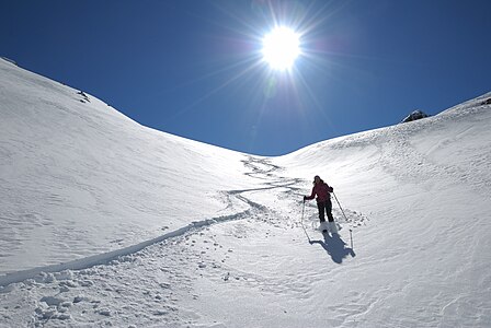
Departure from Fuorcla da Tschitta towards Lai Grond .


literature
- Manfred Hunziker: Club guide, Bündner Alps . From the Septimer to the Flüela. 3. Edition. Vi. Verlag des SAC, 2000, ISBN 3-85902-187-7 , p. 236-237 .
- Vital Eggenberger: Ski tours Graubünden South . Verlag des SAC, 2010, ISBN 978-3-85902-301-7 , pp. 117-120 .
- National map of Switzerland, sheet 1236 Savognin, 1: 25000, Federal Office of Topography, 2009 edition.
Web links
Individual evidence
- ↑ Andrea Schorta: How the mountain got its name . Small Rhaetian name book with two and a half thousand geographical names of Graubünden. Terra Grischuna Verlag, Chur and Bottmingen / Basel 1988, ISBN 3-7298-1047-2 , p. 89 .
- ↑ Andrea Schorta: How the mountain got its name . Small Rhaetian name book with two and a half thousand geographical names of Graubünden. Terra Grischuna Verlag, Chur and Bottmingen / Basel 1988, ISBN 3-7298-1047-2 , p. 144 .
- ↑ IMIS - Intercantonal Measurement and Information System ( Memento of the original dated August 13, 2017 in the Internet Archive ) Info: The archive link was inserted automatically and has not yet been checked. Please check the original and archive link according to the instructions and then remove this notice. . Website of the WSL Institute for Snow and Avalanche Research. Retrieved February 25, 2015.
- ↑ SLF> Snow Info> Measured Values> Wind and Temperature Data> North and Central Grisons ( Memento of the original from July 5, 2017 in the Internet Archive ) Info: The archive link was inserted automatically and has not yet been checked. Please check the original and archive link according to the instructions and then remove this notice. . Website of the WSL Institute for Snow and Avalanche Research. Retrieved February 25, 2014.
- ↑ Bike & hiking bus timetable on the Savognin Bivio Albula holiday region website, accessed on April 8, 2018