Intercantonal measurement and information system


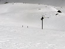
The Intercantonal Measurement and Information System (IMIS) is a network of over 180 automatic wind and snow measuring stations that provides information from remote and / or inaccessible areas at higher altitudes (mainly between 2500 m and 3500 m) in the Swiss Alps . The system is operated by the WSL Institute for Snow and Avalanche Research SLF in cooperation with the federal government, cantons, municipalities and other interest groups in Switzerland .
The stations are set up as a pair, consisting of a wind station and a snow station. Wind stations are exposed at peaks or ridge positions and measure wind speed (mean and peak), wind direction , air temperature and relative humidity . Snow stations are as sheltered from the wind as possible and measure reflected short-wave radiation , snow depth , snow surface temperature, soil temperature, snow temperature within the snow cover at three different heights and at some stations precipitation with a Pluviometer .
Most stations work autonomously with solar power . The measured values are recorded every half hour and sent hourly via GPRS to the headquarters in Davos . The data is made available on various platforms to the avalanche warning service and safety officers throughout Switzerland. In addition, the data is published free of charge on the SLF website.
Web links
- IMIS - intercantonal measurement and information system . Official website of the WSL Institute for Snow and Avalanche Research. Retrieved June 13, 2016.
- SLF> Avalanche bulletin and snow situation> Measured values . Measured values on the website of the WSL Institute for Snow and Avalanche Research. Retrieved May 12, 2019.