
Älplihorn (Albula Alps)
| Älplihorn | ||
|---|---|---|
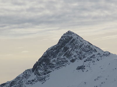
.jpg) Älplihorn recorded by Büelenhorn . |
||
| height | 3006 m above sea level M. | |
| location | Canton of Graubünden , Switzerland | |
| Mountains | Albula Alps | |
| Dominance | 0.426 km → Piz Vadret | |
| Notch height | 426 m ↓ Fanezfurgga | |
| Coordinates | 782 507 / 176 075 | |
|
||
| First ascent | Johann Hauri and companion, in 1878 | |
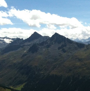
.jpg) The summit of the Älplihorn seen from the south. |
||

The Älplihorn is 3006 m above sea level. M. high mountain between Monstein and Sertig in the Albula Alps in the Swiss canton of Graubünden . The horn culminates in two points that are separated by a small notch. Because of the extensive view, it is often visited in both summer and winter.
Location and surroundings

The Älplihorn belongs to the Monsteiner chain, a subgroup of the Albula Alps . Neighboring mountains in the north are the Leidbachhorn ( 2908 m above sea level ), Marchhüreli ( 2578 m above sea level ), and Rinerhorn ( 2528.1 m above sea level ). The Chrachenhorn ( 2891 m above sea level ) joins in the south . In the east, immediately below the mountain, is the village of Sertig Dörfli , in the west, Monstein . The Älplihorn is located entirely in the municipality of Landschaft Davos .
Snow station

One of the 160 snow stations of the Intercantonal Measurement and Information System (IMIS) is located south of the summit, at 2558 m on a plain in Bärentälli . The system is operated in cooperation with the federal government, cantons, municipalities, the WSL Institute for Snow and Avalanche Research SLF and other interest groups. The associated wind station is located on the Chrachenhorn at 2891 m above sea level. M. The snow station measures the air temperature, surface temperature of the snowpack, temperature within the snowpack, temperature of the ground, wind speed (medium and peak), wind direction, relative humidity, snow depth and reflected short-wave radiation every half hour. The avalanche warning service and safety officers throughout Switzerland are thus provided with the latest information from remote and / or inaccessible areas. The data can be viewed on the SLF website.
Routes to the summit
Summer routes
The southeast flank, which is traversed by inclined bands, is very prone to falling rocks and is therefore not recommended.
Over the south ridge
- Starting point: Monstein ( 1626 m ) or Sand ( 1859 m )
- Via: Bärentällifurgga ( 2745 m ) to the union with the Mitteltallenrat, then to the south summit. From the south summit to the main summit you climb down through a short chimney in the west side, cross a bit to the west of the ridge edge and then climb back onto the ridge.
- From Monstein on the Alpstrasse to Oberalp ( 1913 m ) and on the marked mountain path to the little lake at 2446 m . Then turn left into Bärentälli to Bärentällifurgga (you can also go up the scree slope at the small lake at 2637 m to the north).
- From Sand to Grossalp ( 1882 m ), then along the path to Alpli ( 2375 m ) and steeply up to Bärentällifurgga.
- 3¾ hours from Monstein
- 3¼ hours of sand
Through the middle valley
- Starting point: Monstein ( 1626 m )
- Via: On the alpine road to Oberalp ( 1913 m ) and on the marked mountain path to Fanezmeder ( 1913 m ). Then turn left into Mitteltälli. Then either to the Mitteltallenrat and first to the south summit or directly to the main summit.
- Difficulty: L
- Time required: 3½
From the north
- Starting point: Sand ( 1859 m ), Monstein ( 1626 m ), Jatzmeder mountain station ( 2053 m ) or Glaris ( 1455 m )
- Via: Leidbachfurgga ( 2727 m )
- Difficulty: WS
- Time required: 3¾ hours from Sand, 5 hours from Monstein or Glaris, 4 hours from the Jatzmeder mountain station (1 hour from the Leidbachfurgga)
Winter routes
From Monstein
- Starting point: Monstein ( 1626 m )
- Via: Fanezmeder, Bodmen, Bärentälli, at the Seeli ( 2637 m ) pulling out to the right to the Mitteltallenrat. Ski depot at approx. 2980 m . Now on the northwest side to the main summit.
- Exposures: NW, S
- Difficulty: WS +
- Time required: 4 hours
- Note: Often people only go as far as the south summit.
- Alternative: If the conditions are safe, you can climb or descend through the Mitteltälli instead of through the Bärentälli.
From the Rinerhorn mountain station
- Starting point: mountain station Nüllisch ski lift Rinerhorn ( 2492 m )
- Via: Nüllisch Grat, Wassertälli, Bodmen, P. 2648, Mitteltälli, Südgipfel
- Exposures: W
- Difficulty: Z-
- Time required: 2½ hours
- Note: The transition to the Mitteltälli and the summit slope require safe conditions (30–35 ° at 300 m)
panorama

gallery
Älplihorn seen from the Sertig valley .
Älplihorn and Leidbachhorn (from left to right), taken from Jakobshorn .
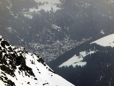
Looking north to Davos .
View to the northeast into the Sertig valley .
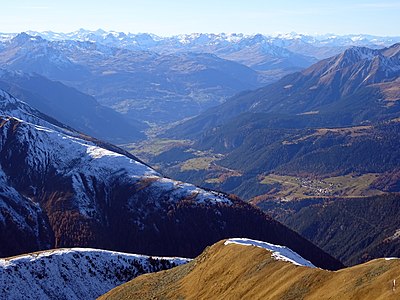
View to the west into the Albula valley .
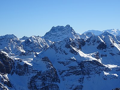
View to the south to Piz Kesch .
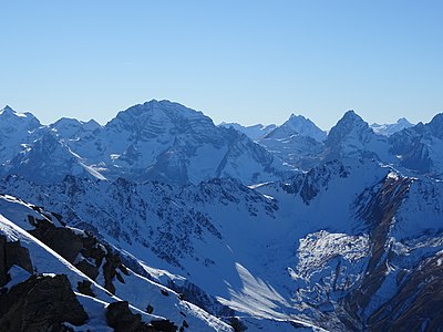
View to the southwest to the Bergüner Stöcken (from left to right Piz Ela , Piz Forbesch and Tinzenhorn ).


.jpg)


literature
- Manfred Hunziker: Club Guide, Bündner Alpen, Volume VI (From Septimer to Flüela). 3. Edition. Verlag des SAC, 2000, ISBN 3-85902-187-7 , pp. 368-369.
- Vital Eggenberger: Ski tours Graubünden South. Verlag des SAC, 2010, ISBN 978-3-85902-301-7 , pp. 187-188.
- Fabian Lippuner, David Coulin: Alpine hiking / summit destinations, Graubünden North. Verlag des SAC, 2013, ISBN 978-3-85902-341-3 , pp. 136-139.
- National map of Switzerland, sheet 1217 Scalettapass, 1: 25000, Federal Office of Topography, 2011 edition.
Web links
Individual evidence
- ↑ Älplihorn, 3006 m above sea level , Information page on the Gipfelbuch.ch website, accessed on August 31, 2013
- ^ IMIS - Intercantonal Measurement and Information System ( Memento from August 13, 2017 in the Internet Archive ). Website of the WSL Institute for Snow and Avalanche Research. Retrieved February 25, 2015.
- ↑ SLF> Snow Info> Measured Values> Wind and Temperature Data> North and Central Grisons ( Memento from July 5, 2017 in the Internet Archive ). Website of the WSL Institute for Snow and Avalanche Research. Retrieved February 25, 2014.