
Büelenhorn (Monstein)
| Büelenhorn | ||
|---|---|---|
 Büelenhorn seen from Mäschenboden |
||
| height | 2808 m above sea level M. | |
| location | Canton of Graubünden , Switzerland | |
| Mountains | Albula Alps | |
| Dominance | 2.5 km → Gipshorn | |
| Notch height | 159 m ↓ Büelenfurgga | |
| Coordinates | 778 089 / 171664 | |
|
||
.jpg) Summit cross and signpost on the Büelenhorn |
||

The Büelenhorn is a mountain south of Davos Monstein and north of Bergün in the canton of Graubünden in Switzerland with an altitude of 2808 m above sea level. M. It is a popular panoramic mountain, which is often visited both in summer and in winter, with an impressive view of the Bergüner sticks and the western half of the Ducan chain. This Büelenhorn is not with the 2513 m above sea level. M. high Büelenhorn near Davos Dorf to be confused.
Location and surroundings

The Büelenhorn belongs to the Monsteiner chain, a subgroup of the Albula Alps . The municipal boundary between Davos and Bergün Filisur runs above the summit . The Büelenhorn is bordered in the south by the Val da Stugl, a side valley of the Albula valley , and in the north by the Landwassertal .
The main ridge stretches from the Stulsergrat in the west over the summit to the Mäschengrat in the east. A wide ridge begins a little to the west of the peak and continues to the north. The ridge is hardly noticed in mountaineering.
The neighboring peaks include the Gipshorn in the east, the Piz Prosonch in the south and the Muchetta in the west.
The valley locations are Bergün and Monstein.
Tightrope walk

The ridge hike from Monstein ( 1636 m ) via Büelenhorn ( 2808 m ) - Stulsergrat ( 2678 m ) - Muchetta ( 2623 m ) to Filisur ( 1032 m ) or Wiesen Station ( 1197 m ) is a long, but easy and promising day tour. It offers a great panoramic view of the entire Central Grisons with a view of the Albula Valley , Landwassertal , Davos and the Bergüner Stocks .
The whole tour is a walking trail white-red-white marked, the trail is not continuously visible. The tour to Wiesen Station takes 6–7 hours, to Filisur ½ hour longer. The difficulty of the tour is T3 .
Routes to the summit
.jpg)
Summer routes
From the north

- Starting point: Davos Monstein ( 1626 m )
- Via: Unteralp, Inneralp, Mittelalp, Mäschenboden ( 1993 m ) to the north ridge, and then over the west ridge to the summit.
- Difficulty: T3 , EB , partially cautiously marked white-red-white as a hiking trail .
- Time required: 3½ hours
Over the east ridge
- Starting point: Davos Monstein ( 1626 m ) or Stugl ( 1551 m )
- Via: Büelenfurgga ( 2649 m )
- Difficulty: L
- Time required: 3½ hours from Monstein or 4 hours from Stugl (½ hour from Büelenfurgga)
From the south
- Starting point: Stugl ( 1551 m )
- Via: Alp da Stugl ( 2048 m ), Bott'Ota ( 2685 m )
- Difficulty: BG-
- Time required: 3¾ hours
- Alternative: Not to Bott'Ota, but directly to the ridge valley at 2641 m
Over the Stulsergrat
- Starting point: Muchetta ( 2623 m )
- Via: Stulsergrat, mostly directly above the ridge height, in parts on sheep trails, elsewhere without paths.
- Difficulty: T3 , EB , cautiously marked white-red-white as a hiking trail .
- Time required: 1¼ hours
- Note: For routes to the Muchetta, see the Muchetta article .
Winter routes
From Monstein
- Starting point: Davos Monstein ( 1626 m )
- Via: Unteralp, Inneralp, Mitelalp, Mäschenboden ( 1993 m ) to the north ridge
- Exposures: N, NE
- Difficulty: WS +
- Time required: 3½ hours
From Stugl
Rarely performed spring ski tour.
- Starting point: Stugl ( 1551 m )
- Via: Alp da Stugl ( 2048 m ), Fuppatsch, Gratsenke at 2641 m , finally on foot to the summit
- Exposures: S
- Difficulty: ZS-
- Time required: 4 hours
- Alternative: If poor conditions do not allow you to climb the summit, Bott'Ota ( 2685 m ) to the south-west can be a worthwhile alternative.
- Descent: along the ascent route. From Alp da Stugl ( 2048 m ) you can descend in a 1-hour counter-climb to Cuolm da Latsch ( 2296 m ) and then to Latsch ( 1588 m ) ( L ).
panorama
,_Panorama.jpg)
gallery

View to the west into the Albula valley .

Looking north to Davos
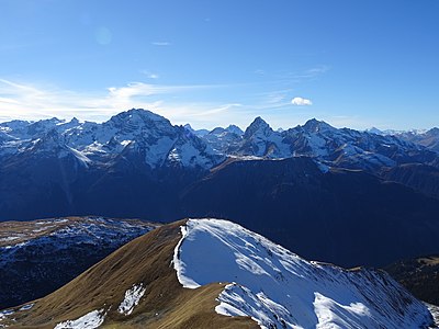
View to the southwest to the Bergüner Stöcken with (from left to right) Piz Ela , Piz Platta , Piz Forbesch , Tinzenhorn and Piz Mitgel .

View to the southeast to Piz Kesch .

View to the northeast to the Älplihorn .
.jpg)
.jpg)
.jpg)
.jpg)
.jpg)
literature
- Manfred Hunziker: Club Guide, Bündner Alpen, Volume VI (From Septimer to Flüela). 3. Edition. Verlag des SAC, 2000, ISBN 3-85902-187-7 , pp. 354-357.
- Vital Eggenberger: Ski tours Graubünden South. Verlag des SAC, 2010, ISBN 978-3-85902-301-7 , pp. 184-186.
- Fabian Lippuner, David Coulin: Alpine hiking / summit destinations, Graubünden North. Verlag des SAC, 2013, ISBN 978-3-85902-341-3 , pp. 140-143.
- National map of Switzerland, sheet 1217 Scalettapass , 1: 25000, Federal Office of Topography, 2011 edition.