
Muchetta
| Muchetta | ||
|---|---|---|
 Muchetta, recorded by Schmitten |
||
| height | 2622.8 m above sea level M. | |
| location | Canton of Graubünden , Switzerland | |
| Mountains | Albula Alps | |
| Dominance | 1.33 km → Stulsergrat | |
| Notch height | 52 m ↓ ridge between Muchetta and Stulsergrat | |
| Coordinates | 775 463 / 171 895 | |
|
||
 Summit of the Muchetta |
||
 Summit cross on the pre-summit west of the Muchetta |
||

The Muchetta ( Rhaeto-Romanic for fire extinguisher ) is a mountain between Davos Wiesen and Bergün in the canton of Graubünden in Switzerland with a height of 2622.8 m above sea level. M. On the west ridge the mountain has at 2585 m above sea level. M. a pre-summit with stone man, summit cross, summit book and a signpost. This pre-summit often serves as a tour destination with a comprehensive view of the Albula valley. At the summit, however, the view is complemented by the view of the Davos Mulde .
Location and surroundings
The Muchetta belongs to the Monstein chain, a subgroup of the Albula Alps . The municipal boundary between Bergün and Filisur ran above the summit until the municipal merger in 2018 . The Muchetta is bordered in the north by the Landwassertal and in the south by the Albula valley.
The neighboring peaks in the east include the Stulsergrat and the Büelenhorn . To the southwest of the Muchetta are the Bergüner sticks with Piz Ela , Tinzenhorn and Piz Mitgel .
Valley locations are Wiesen , Filisur and Bergün .
Origin of name
The mountain resembles a sugar loaf , but also a fire hat ( Muchetta in Rhaeto-Romanic ), with which you put out the candles. The word is derived from the Latin word muccus for snot , or muccare for blowing your nose, from which the meaning light cleaning scissors , extinguishing cap is understandable.
Tightrope walk

The ridge hike from Monstein ( 1636 m ) via Büelenhorn ( 2808 m ) - Stulsergrat ( 2678 m ) - Muchetta ( 2623 m ) to Filisur ( 1032 m ) or Wiesen Station ( 1197 m ) is a long, but easy and promising day tour. It offers a great panoramic view of the entire Central Grisons with a view of the Albula Valley , Landwassertal , Davos and the Bergüner Stocks .
The whole tour is a walking trail white-red-white marked, the trail is not continuously visible. The tour to Wiesen Station takes 6–7 hours, to Filisur ½ hour longer. The difficulty of the tour is T3 .
Routes to the summit

Over the west ridge
- Starting point: Filisur ( 1080 m )
- Via: Curtins ( 1870 m ), Vorgipfel ( 2585 m )
- Difficulty: B than trail white-red-white marks
- Time required: 4½ hours (¼ hour from the pre-summit)
Through the north flank
- Starting point: Wiesen Station ( 1197 m )
- Via: Jenisberg ( 1504 m ), Jenisberger Alp ( 1989 m ), Drostobel, Vorgipfel ( 2585 m )
- Difficulty: EB , as trail white-red-white marks
- Time required: 4 hours (¼ hour from the pre-summit)
Over the southern slope
- Starting point: Stugl ( 1551 m )
- Via: Runsolas ( 1724 m ), Grathöhe on P. 2612
- Difficulty: B than trail white-red-white marks
- Time required: 3¼
Over the east ridge
- Starting point: Büelenhorn ( 2808 m )
- Via: Stulsergrat
- Difficulty: EB , as trail white-red-white marks
- Time required: 1¼ hours
- Note: For routes to the Büelenhorn see the article Büelenhorn (Monstein) .
panorama

gallery

Blich to the southwest to the Bergüner Stöcken with (from left to right) Piz Ela , Tinzenhorn and Piz Mitgel .

View into the Albula valley .

View to the northeast into the valley of Davos .

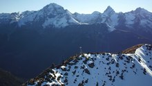
View to Schmitten .

View to Wiesen with the Wiesen Viaduct .

Muchetta is the Romansh name for fire extinguisher


literature
- Manfred Hunziker: Club Guide, Bündner Alpen, Volume VI (From Septimer to Flüela). 3. Edition. Verlag des SAC, 2000, ISBN 3-85902-187-7 , pp. 352-353.
- Fabian Lippuner, David Coulin: Alpine hiking / summit destinations, Graubünden North. Verlag des SAC, 2013, ISBN 978-3-85902-341-3 , pp. 140-143.
- National map of Switzerland, sheet 1216 Filisur, 1: 25000, Federal Office of Topography, 2011 edition.
Web links
Individual evidence
- ↑ Andrea Schorta: How the mountain got its name . Small Rhaetian name book with two and a half thousand geographical names of Graubünden. Terra Grischuna Verlag, Chur and Bottmingen / Basel 1988, ISBN 3-7298-1047-2 , p. 106 .