
Piz Mitgel
| Piz Mitgel | ||
|---|---|---|
 View from the Oberhalbstein |
||
| height | 3,158.8 m above sea level M. | |
| location | Canton of Graubünden , Switzerland | |
| Mountains | Albula Alps | |
| Dominance | 1.93 km → Tinzenhorn | |
| Notch height | 452 m ↓ connecting ridge between Piz Mitgel and Tinzenhorn | |
| Coordinates | 769 111 / 165 032 | |
|
||
| rock | dolomite | |
| First ascent | August 1, 1867 by MCAS Coolidge and F. and H. Devouassoud | |
| Normal way | About Senda Diagonala and Senda Finala | |
| particularities | Senda Ferrada via ferrata | |
.jpg) Bergüner Stätze with Piz Mitgel (right), taken from the northeast (Dorfberg above Davos ) |
||
 Bergüner Stätze with Piz Mitgel (left), taken from the southwest ( Val Schmorras in Val Nandro , Oberhalbstein ) |
||
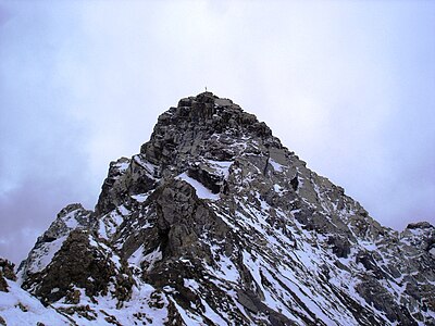
 Summit cross on Piz Mitgel |
||

The Piz Mitgel is a mountain northeast of Savognin and southwest of Filisur in the canton of Graubünden in Switzerland with a height of 3,158.8 m . The first ascent took place on August 1, 1867 by William Augustus Brevoort Coolidge and the brothers François and Henri Devouassoud. Petrified dinosaur footprints have been found on Piz Mitgel . The Piz Mitgel offers a magnificent view, especially of the Oberhalbstein , the Albula valley and the Heinzenberg .
Location and surroundings
The Piz Mitgel belongs to the Bergüner sticks , a subgroup of the Albula Alps . The Piz Mitgel separates the Albula valley in the north from the Oberhalbstein in the south-west . The municipal boundaries of Albula / Alvra , Surses and Bergün Filisur meet 200 m north of the summit (P. 3098) . The municipal boundary between Surses and Bergün Filisur runs over the summit.
The Tinzenhorn , Piz Ela and Pizza Grossa are among the neighboring peaks of Piz Mitgel .
To the northwest of Piz Mitgel, at the end of the mountain range , is the Motta Palousa ( 2143.6 m ), a vantage point that is often used and offers an excellent panorama over the Oberhalbstein, the Domleschg and the Albula valley. The way to Motta Palousa is well marked. To the south-east of Piz Mitgel is the mountain lake Lai Tigiel ( 2462 m ), which is also often visited .
The mountain is in the middle of Parc Ela , a 600 square kilometer nature park opened in 2006 .
Valley locations are Savognin and Tinizong in Oberhalbstein and Filisur and Bergün in the Albula valley. Starting points are the Ela hut in the lonely Val Spadlatscha and the Alp Plang la Curvanera, which can be reached via a narrow alpine road .
Fossil finds

Petrified footprints of dinosaurs were found on the Tinzenhorn and Piz Mitgel . The traces come from sauropods from the Triassic period , when the rocks were still at sea level 200 to 210 million years ago. The tracks are considered to be the oldest such evidence in the world.
Senda Ferrada
Attention, due to the increased risk of falling rocks, the via ferrata will remain closed until further notice . The ropes have been partially removed in the Senda Diagonala and also in the Senda Verticala. This makes an inspection much more difficult and is at your own risk. Any liability is rejected.
Since 2005 it has been possible to climb Piz Mitgel via the Senda Ferrada via ferrata . There are three climbing routes available: the Senda Verticala , the Senda Diagonala and the Senda Finala .
Senda VerticalaThe main ascent is technically and physically difficult. This route has some difficulties and we do not recommend it with children or untrained people.
Senda diagonalThe former normal route is secured with wire ropes and is also suitable for less experienced mountaineers.
Senda FinalaSummit tour on the summit of Piz Mitgel.
|


Signposts where Senda Verticala and Senda Diagonala separate

Climbers on the Senda Verticala .

Climber on the Senda Verticala .

The end of the Senda Verticala . To see: the overhang (Igl Tetg) and further down the Segantini ridge (Cresta Segantini).

Senda diagonal seen from below.

Mountaineers on the Senda Finala .


Routes to the summit
The Piz Mitgel is usually climbed from the valley in one day. A frequent starting point is the Plang la Curvanera car park ( 1893 m above sea level ), to which a small road leads from Savognin via Tussagn. The alpine road from Tinizong into the Val d'Err to Penza is closed to general motor vehicle traffic. A hiking bus runs from Savognin to Plang la Curvanera on Wednesdays and to Pensa on Tuesdays and Fridays.
From the southwest across the wide belt
Normal route, via Senda Diagonala and Senda Finala.
- Starting point: Savognin ( 1207 m ) or Plang la Curvanera ( 1793 m ) or Elahütte ( 2252 m )
- Marked as an Alpine Route in white-blue-white
- Difficulty: WS
- Time required: 5–6 hours from Savognin, 3½– 4½ hours from Plang la Curvanera, 5–6 hours from the Elahütte
Over the west ridge
Normal route to Piramida
- Starting point: Piramida ( 2752 m )
- Difficulty: ZS-
- Time required: 2-2½ hours from the Piramida
Through the east wall
- Starting point: Filisur ( 1032 m ) or Elahütte ( 2252 m )
- Difficulty: WS
- Time required: 6½ hours from Filisur or 4½ hours from the Elahütte
Over the southeast ridge
Varied climbing
- Starting point: connecting ridge east of P.2758.6
- Difficulty: ZS
- Time required: 4–5 hours
Through the south wall to the southeast ridge
Way of the first climber
- Starting point: P.2506.1 above Tgant Son Martegn
- Difficulty: WS
- Time required: 3 hours
Through the south wall
- Starting point: P.2506.1 above Tgant Son Martegn
- Difficulty: WS
- Time required: 2–3 hours
panorama

gallery
Summit taken from the northeast ridge.
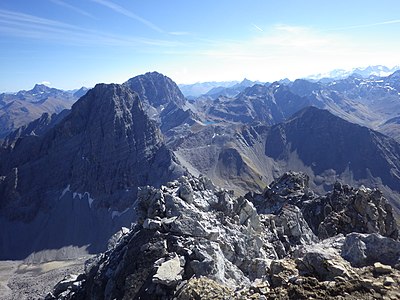
View to the other mountains of the Bergüner sticks . V. l. No. Tinzenhorn , Piz Ela and Pizza Grossa .
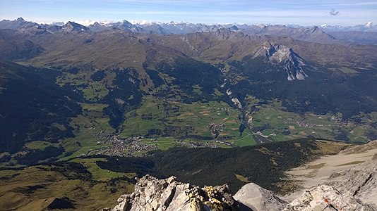
Looking west to Savognin , Cunter , Riom-Parsonz and Salouf .

View to the northeast of Davos .

View to the northwest into Domleschg and Lenzerheide .

Piz Mitgel, recorded from Domleschg

Bergüner sticks, taken from the Weissfluhjoch .


literature
- Eugen Wenzel, Paul Gross: Club Guide, Bündner Alpen, Volume VI (Albula) 2nd edition. Verlag des SAC, 1980, ISBN 3-85902-012-9 , pp. 133-136.
- Peter Donatsch, David Coulin: The most beautiful summit destinations of the Swiss Alps East 2nd edition, 2002, pp. 83–84, AT-Verlag, Aarau. ISBN 3-85502-907-5 .
- Iris Kürschner: Via ferrata Switzerland 2nd edition, 2006, pp. 58–60, Bergverlag Rother , Munich. ISBN 3-7633-4305-9 .
Web links
- Panorama from Piz Mitgel
- www.hikr.org Various tour reports
- www.summitpost.org Tourism
- www.alpen-panoramen.de Panorama from Piz Mitgel
Individual evidence
- ↑ swissinfo ; Retrieved September 3, 2010.
- ^ Project Dinosaurs grischuns ; Retrieved September 3, 2010.
- ↑ climbing | Savognin Bivio Albula Website of Tourismus Savognin Bivio Albula AG. Retrieved May 23, 2020.
- ↑ Bike & hiking bus timetable on the Savognin Bivio Albula holiday region website, accessed on April 8, 2018