Salouf
| Salouf | |
|---|---|
| State : |
|
| Canton : |
|
| Region : | Albula |
| Political community : | Surses |
| Postal code : | 7462 |
| former BFS no. : | 3538 |
| Coordinates : | 763.6 thousand / 165 977 |
| Height : | 1258 m above sea level M. |
| Area : | 31.49 km² |
| Residents: | 216 (December 31, 2014) |
| Population density : | 7 inhabitants per km² |
| Website: | www.surses.ch |
|
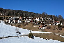
Salouf with the Piz Toissa |
|
| map | |
Salouf ( German and officially Salux until 1943, pronounced locally as [ sa'lɔːkf ] due to the diphthong hardening ) was until December 31, 2015 a political municipality in the Surses district in the Albula district of the canton of Graubünden in Switzerland . On January 1, 2016, Salouf merged with the municipalities of Bivio , Cunter , Marmorera , Mulegns , Riom-Parsonz , Savognin , Sur and Tinizong-Rona to form the new municipality of Surses .
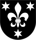
coat of arms
Blazon : in black a silver (white) lily accompanied by three six-pointed silver stars .
The main motif of the coat of arms , the lily, is the coat of arms of Benedikt Fontana from Salouf . The stars were added to distinguish it from his coat of arms.
geography
The former municipality is located on a terrace on the eastern slope of Piz Toissa (2657 m) to the left above the valley floor of the Julia . In addition to the village, the hamlets of Pulens (1386 m) and Del (1373 m) also belong to the municipality. Of the entire former municipal area of over 31 km², 1336 hectares are usable for agriculture. Of this area, however, 1112 hectares are only used as alpine pastures. A further 885 hectares are covered by forest and wood and 883 hectares are unproductive area (mostly mountains in the western part of the municipality). The remainder of 37 ha is settlement area.
history
The first Bronze Age settlement emerged around 2100 BC. BC on the Motta Vallac , a hilltop visible from afar, on the north side of today's village. Roman settlement remains from the first century AD have also been proven.
In the Middle Ages there was probably a Rhaeto-Romanic settlement near what is now the hamlet of Del. When the first German-speaking Walser people moved through the valley towards the end of the 13th century, they mainly settled in the upper half of the valley and the side valleys (Alp Flix, Radons and Val Faller). But also in the lower half of the valley, in the settlement area of today's village of Salouf, Walsers lived as early as 1300. After several plague outbreaks in the 14th and 15th centuries, the Rhaeto-Romanic settlement in Del was largely abandoned and rebuilt around the Walser settlement. The oldest buildings in the districts of Mezvei and Sumvei are still of Walser origin.
population
| year | 1850 | 1900 | 1950 | 1980 | 1990 | 2000 | 2005 | 2014 |
|---|---|---|---|---|---|---|---|---|
| Residents | 413 | 287 | 289 | 157 | 185 | 205 | 213 | 216 |
languages
The language of the population is Surmeir , a regional dialect of Rhaeto-Romanic . Until around 1980 the majority of the population spoke Romansh. In 1880 it was 99.1%, in 1910 91.43% and in 1980 88.54%. Since then the language has been losing ground. Not as strong as in many municipalities in the region, however. The table below shows the development over the past decades:
| languages | 1980 census | 1990 census | 2000 census | |||
|---|---|---|---|---|---|---|
| number | proportion of | number | proportion of | number | proportion of | |
| German | 13 | 8.28% | 24 | 12.97% | 40 | 19.51% |
| Romansh | 139 | 88.54% | 152 | 82.16% | 159 | 77.56% |
| Italian | 4th | 2.55% | 4th | 2.16% | 2 | 0.98% |
| Residents | 157 | 100% | 185 | 100% | 205 | 100% |
The only official language is Romansh, which is understood by 86.3% of the population.
Origin and nationality
Of the 213 residents at the end of 2005, 208 (= 97.65%) were Swiss citizens.
politics
Municipal council
The mayor was Gian Sonder.
Attractions
The village is characterized by some residential tower-like Walser houses from the 13th century as well as by style and dimensions striking houses from the 17th to 19th centuries. The importance of cattle breeding can be seen from the many wooden stables spread across the village. Individual houses have restored house facades and sgraffiti .
The birth house of the Bündner freedom hero Benedikt Fontana , a stately building from the 17th century, stands in a part of the house at the village exit to Savognin. The restored bakery from the late 18th century is also worth seeing. Salouf originally served as a fortress, covering the back of the Riom Castle dam . You can still find loopholes in the house walls facing the valley.
Ziteil , the highest church in Europe, is located in the former parish of Salouf . The pilgrimage church with pilgrims' house stands at an altitude of 2429 m above sea level. M. According to legend, there were two apparitions of Mary in the summer of 1580. Probably shortly after the second apparition, a modest chapel was built in Ziteil. The current church dates from 1848, was enlarged in 1957 and another storeyed in 1977. It is therefore largely no longer preserved in its origin.
The parish church of St. Georg (S. Gieri) is at the northern end of Salouf. The church is dominated by a campanile , the lower parts of which go back to the Romanesque period. From the Romanesque building, which is mentioned for the first time around 1290, the surrounding walls of the nave have been preserved next to the tower. In 1498 the new building of the choir was completed, in 1501 the bell storey was built and the nave was vaulted. The high altar from around 1515 comes from the workshop of Jörg Syrlin (1455–1521). In 1880 the ship was lengthened by a yoke. In 1968 the restorer Erhard Ressel from Fischingen uncovered old fragments of a Gothic painting. The sequence of images was probably made towards the end of the 14th century.
Also noteworthy is the former Capuchin hospice built in 1750 (today the rectory); the order had great influence in Salouf.
The Mulegn Vigl mill from 1877 in the hamlet of Mulegn is still preserved today and is considered one of the longest hydropower-operated grain mills in Switzerland and was in operation until the mid-1990s.
In a ravine below Salouf at a good 1100 m, at the confluence of the Balandegn mountain stream in the Julia, lies the old iron smelter at Stein Flecs (Ferreia Istorica) . The iron smelter was built in 1828 by Martin Versell from Bludenz and restored in 1981 by the “Friends of Mining” association. The blast furnace was in operation until around 1850 and the forge until around 1900.
Sons and daughters
- Claudia Demarmels (* 1954), actress
- Benedikt Fontana (* around 1450), Bündner national hero
literature
- Erwin Poeschel : The art monuments of the canton of Graubünden III. The valley communities Räzünser Boden, Domleschg, Heinzenberg, Oberhalbstein, Upper and Lower Engadine. (= Art Monuments of Switzerland. Volume 11). Edited by the Society for Swiss Art History GSK. Bern 1940. DNB 760079625 .
- The municipalities of the canton of Graubünden. Chur / Zurich, 2003. ISBN 3-7253-0741-5
- Gerhard Eckert : Switzerland. DuMont Art Guide, Cologne 1978, 4th edition 1983. P. 217
- Gion Peder Thöni: Salouf. In: Historical Lexicon of Switzerland . 2016 .
- Adolf Collenberg: Ziteil. In: Historical Lexicon of Switzerland . 2017 .
Web links
- Salouf on the ETHorama platform
- Official website of the municipality of Salouf
- Site Mulegn Vigl (old mill) Salouf
Individual evidence
- ↑ Motta Vallac on ETHorama
- ^ Catholic parish church of St. Georg
- ↑ Description on the website for Bündner Baukultur


