
Piz Toissa
| Piz Toissa | ||
|---|---|---|
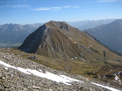
 Piz Toissa with Salouf in the foreground |
||
| height | 2657 m above sea level M. | |
| location | Canton of Graubünden , Switzerland | |
| Mountains | Oberhalbsteiner Alps | |
| Dominance | 1.5 km → Curvér Pintg da Taspegn | |
| Notch height | 310 m ↓ Furcletta | |
| Coordinates | 759.76 thousand / 165184 | |
|
||
| rock | Tufa | |
| Normal way | About Furcletta | |
| particularities | Crater-shaped appearance | |
|
Aerial view from Piz Toissa |
||


The Piz Toissa is a mountain west of Salouf in the canton of Graubünden in Switzerland with an altitude of 2657 m above sea level. M. He is separated from CURVER massif by the dip of Furcletta. It is particularly noticeable because of its volcano-like appearance.
Location and surroundings

The Piz Toissa belongs to the Piz Curvér group , a subgroup of the Oberhalbsteiner Alps . It lies entirely within the territory of the municipality of Surses .
The neighboring peaks include the Piz Curvér and the Curvér Pintg da Taspegn.
To the southwest of Piz Toissa is the Marian shrine Ziteil , with its 2429 m above sea level. M. the highest pilgrimage site in the Eastern Alps .
Valley communities are Salouf and Mon . Frequent starting points are the Cre digl Lai and Munter car parks or the Ziteil pilgrimage site.
Giovanni Segantini
Landscape pictures by the painter Giovanni Segantini (1858–1899) show Piz Toissa and Piz Curvér in the background . The Senda Segantini hike, which lasts several days, combines stations from the painter's life and leads to Parsonz on the southeast flank of Piz Toissa.
Routes to the summit
Over the west ridge
- Starting point: Furcletta ( 2347 m )
- Difficulty: EB
- Time required: ¾ hours
(See below for route to Furcletta)
Through the Val Gronda
- Starting point: Salouf ( 1258 m ) or Cre digl Lai car park ( 1780 m )
- Difficulty: BG-
- Time required: 4¼ hours from Salouf or 2¾ hours from Cre digl Lai
Furcletta
Through the Got Grond:
- Starting point: Mon ( 1231 m ), Salouf ( 1258 m ) or Munter car park ( 1860 m )
- Route: Through the Got Grond, Munter
- Difficulty: mountain hikers
- Time required: 3¼ hours from Mon or Salouf, 1½ hours from the Munter car park
About Cre digl Lai:
- Starting point: Salouf ( 1258 m ) or Cre digl Lai car park ( 1780 m )
- Route: On the mountain trail to Cre digl Lai, Furcla
- Difficulty: mountain hikers
- Time required: 2¾ hours from Salouf, 1½ hours from the Cre digl Lai car park
panorama

gallery

Parsonz with Salaschigns and Piz Toissa in the background.
Piz Toissa and Ziteil, taken from the eastern slope of Piz Curvér

Ascent towards Piz Toissa
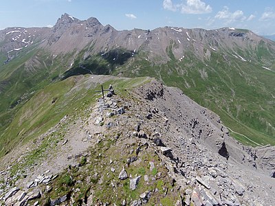
Aerial view from Piz Toissa
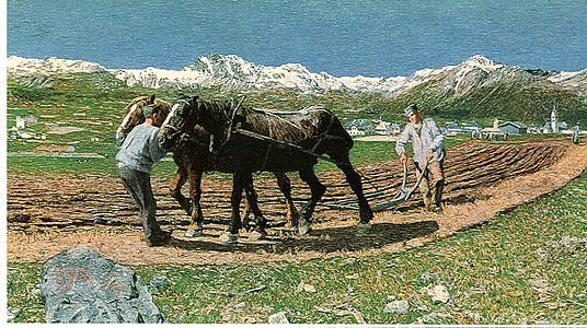
The Plowing ( L'oorera ) by Giovanni Segantini with Piz Toissa and Piz Curvér in the background
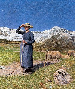
Midday in the Alps ( Mezzogiorno sulle alpi ) by Giovanni Segantini with Piz Toissa and Piz Curvér in the background


literature
- Manfred Hunziker: Club Guide, Bündner Alpen, Volume 3 (obverse) 1st edition. Verlag des SAC, 1994, ISBN 3-85902-140-0 , pp. 302-303.
Web links
- Panorama from Piz Toissa
- www.hikr.org Various tour reports
- www.alpen-panoramen.de Panorama from Piz Toissa
credentials
- ↑ Hiking in Switzerland in the footsteps of Giovanni Segantini through Salouf, Graubünden ( Memento of the original from March 14, 2015 in the Internet Archive ) Info: The archive link was inserted automatically and has not yet been checked. Please check the original and archive link according to the instructions and then remove this notice.