
Piz Curvér
| Piz Curvér | ||
|---|---|---|
 Piz Curvér with Parsonz in the foreground |
||
| height | 2971.8 m above sea level M. | |
| location | Canton of Graubünden , Switzerland | |
| Mountains | Oberhalbsteiner Alps | |
| Dominance | 8.17 km → Piz Grisch | |
| Notch height | 455 m ↓ Fuorcla Cotschna | |
| Coordinates | 757 695 / 163 428 | |
|
||
| First ascent | July 1, 1843 by Johann Wilhelm Fortunat Coas | |
| Normal way | Over the eastern slope | |
| particularities | Ziteil on the eastern flank of Piz Curvér | |

The Piz Curvér (from the Latin corvarius to corvs, raven ) is a mountain east of Pignia and west of Riom-Parsonz and Salouf in the canton of Graubünden in Switzerland with a height of 2971.8 m above sea level. M. It forms the southern end of an elongated, wide rubble ridge that becomes sharper towards the tip . The Curvér Pintg da Neaza ( 2721 m ) and the Curvér Pintg da Taspegn ( 2731 m ) (pintg is Rhaeto-Romanic for small ) are on the same rubble ridge .
Location and surroundings
The Piz Curvér is the namesake of the Piz Curvér group , a subgroup of the Oberhalbsteiner Alps . The municipal boundaries of Surses , Andeer and Zillis-Reischen meet at the summit . The municipal boundaries of Albula / Alvra , Surses and Zillis-Reischen meet at the summit of Curvér Pintg da Taspegn . The ridge separates the Oberhalbstein in the east from the Schams in the west.
The neighboring peaks include the Curvér Pintg da Taspegn, the Piz Toissa , the Piz Martegnas , the Piz Cartas , Sur Carungas , the Piz digl Gurschus , the Piz la Tschera , the Curvér Pintg da Neaza and the Piz Neaza .
When visibility is clear, the Stammerspitze 73 km away can be seen in the northeast and the similarly distant Gross Windgallen , Säntis and the Maasplanggstock 84 km away in the northwest. The greatest distant view is in the southwest, where you can see the Mönch , the Jungfrau , the Aletschhorn , the Nordend , the cathedral and even the Bishorn 147 km away .
Ziteil pilgrimage site
On the eastern flank of Piz Curvér is the Marian shrine Ziteil , with its 2429 m above sea level. M. the highest pilgrimage site in the Eastern Alps .
Giovanni Segantini
Landscape pictures by the painter Giovanni Segantini (1858–1899) show Piz Toissa and Piz Curvér in the background . A multi-day hike called Senda Segantini connects stations from the painter's life and also leads to Parsonz on the eastern flank of the Piz Curvér.
Routes to the summit
Valley locations are Obermutten , Mon , Salouf , Riom, Parsonz, Andeer , Pignia and Zillis . Frequent starting points are the Cre digl Lai, Ziteil, Bavugls and Alp Taspegn car parks.
- Over the northwest ridge
- Starting point: Zillis ( 945 m ) or Alp Taspegn ( 2199 m )
- Difficulty: EB
- Time required: 5½ hours from Zillis, 2 hours from Alp Taspegn
- About Bavugls
- Starting point: Pignia ( 1049 m ) or Bavugls ( 1940 m )
- Difficulty: EB
- Time required: 4¾ hours from Pignia, 2½ hours from Bavugls
- Over the north ridge
- Starting point: Curvér Pintg da Taspegn ( 2731 m )
- Difficulty: WS-
- Time required: 1½ hours
(Route to Curvér Pintg da Taspegn see below)
- Through the western rubble basin
- Starting point: Curvér Pintg da Taspegn ( 2731 m )
- Difficulty: EB
- Time required: 1 hour 20 minutes
(Route to Curvér Pintg da Taspegn see below)
- Through the eastern flank
- Starting point: Curvér Pintg da Taspegn ( 2731 m )
- Difficulty: EB
- Time required: 1½ hours
(Route to Curvér Pintg da Taspegn see below)
- Over the eastern slope
| . |
|

- Through the southeast wall
- Starting point: Colmet Pass ( 2676 m )
- Difficulty: BG
- Time required: 1½ hours
(See below for route to Pass Colmet)
- Over the south ridge
- Starting point: Colmet Pass ( 2676 m )
- Difficulty: ZS
- Time required: 3 hours
(See below for route to Pass Colmet)
- Winter (over the eastern slope)
The ascent requires very good alpine winter knowledge and experience.
- Starting point: Ziteil ( 2429 m )
- Difficulty: Very good alpine skier
- Time required: 2 hours
Curvér Pintg da Taspegn
- Over the north ridge
- Starting point: Obermutten ( 1863 m )
- Difficulty: B
- Time required: 2½ hours
- Through the eastern flank
- Over the southwest slope
- Starting point: Zillis ( 945 m ) or Alp Taspegn ( 2199 m )
- Difficulty: EB
- Time required: 4¾ hours from Zillis or 1½ hours from Alp Taspegn
Colmet Pass
- About Bavugls
- Starting point: Pignia ( 1049 m ) or Bavugls ( 1940 m )
- Marked as a white-red-white hiking trail
- Difficulty: EB
- Time required: 4¾ hours from Pignia or 2½ hours from Bavugls
- Over the Lai da Picogns
- Starting point: Ziteil ( 2433 m )
- Marked as a white-red-white hiking trail
- Difficulty: B
- Time required: 1 hour
- Through the Val Cumegna
- Starting point: Salouf ( 1258 m ) or Cre digl Lai car park ( 1903 m )
- Difficulty: B
- Time required: 4 hours from Salouf or 2½ hours from Cre digl Lai
panorama


gallery
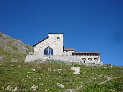
The Marian shrine Ziteil on the eastern flank of Piz Curvér

On the ridge between Piz Curvér and Curvér Pintg da Taspegn
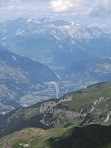
View of the Domleschg .

View to Lenzerheide .

View into Oberhalbstein .


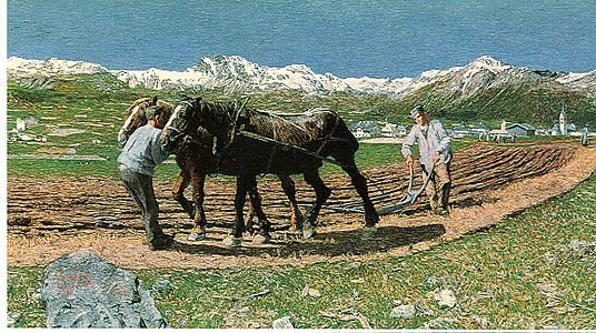
The Plowing ( L'oorera ) by Giovanni Segantini with Piz Toissa and Piz Curvér in the background
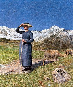
Midday in the Alps ( Mezzogiorno sulle alpi ) by Giovanni Segantini with Piz Toissa and Piz Curvér in the background

The Evil Mothers ( Le cattive madri ) by Giovanni Segantini with Piz Toissa and Piz Curvér in the background


literature
- Manfred Hunziker: Club Guide, Bündner Alpen, Volume 3 (obverse) 1st edition. Verlag des SAC, 1994, ISBN 3-85902-140-0 , pp. 295-304.
- Georg Calonder: Alpine Skitouren, Volume 2 (Graubünden) 4th edition. Verlag des SAC, 1992, ISBN 3-85902-060-9 , p. 164.
Web links
- Piz Curvér on the ETHorama platform
- Panorama from Piz Curver
- www.hikr.org Tour report
Individual evidence
- ↑ Hiking in Switzerland in the footsteps of Giovanni Segantini through Salouf, Graubünden ( Memento of the original from March 14, 2015 in the Internet Archive ) Info: The archive link was inserted automatically and has not yet been checked. Please check the original and archive link according to the instructions and then remove this notice.