Piz Cartas
| Piz Cartas | ||
|---|---|---|
|
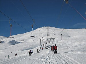
Piz Cartas in winter |
||
| height | 2712 m above sea level M. | |
| location | Canton of Graubünden , Switzerland | |
| Mountains | Oberhalbsteiner Alps | |
| Dominance | 0.72 km → Sur Carungas | |
| Notch height | 94 m ↓ notch between Piz Cartas and Sur Carungas | |
| Coordinates | 759 109 / 159 651 | |
|
|
||
| rock | Slate rubble | |
| Development | Double ski lift from Savognin Bergbahnen | |
| Normal way | About radons | |
The Piz Cartas (from Rhaeto-Romanic , in the Idiom Surmiran "quartas" for fourth , "the fourth peak" ) is a mountain southwest of Savognin and east of Ausserferrera in the canton of Graubünden in Switzerland with a height of 2712 m above sea level. M. It is accessible by the Savognin mountain railways with a double ski lift and forms the highest mountain in the ski area.
Location and surroundings
The Piz Cartas belongs to the Piz Curvér group , a sub -group of the Oberhalbsteiner Alps . The municipal boundary between the former municipalities of Salouf and Riom-Parsonz , which now both belong to the municipality of Surses , ran across the summit .
The neighboring peaks include the Piz Martegnas , Piz Arlos , Piz Arblatsch , Piz Forbesch , Piz Mez , Sur Carungas and Piz Curvér .
The Savognin ski area is located on the eastern flank of Piz Cartas .
Valley locations are Savognin, Riom and Parsonz. Frequent starting points are Somtgant (accessible by train) and Radons (accessible by car).
Routes to the summit
About Somtgant
- Starting point: Somtgant ( 2117 m ), Tigignas ( 1592 m ), Parsonz ( 1367 m ), Riom ( 1257 m ) or Savognin ( 1207 m )
- Route: Somtgant, mountain station Naladas, Cartas, over the northeast slope to Piz Cartas
- Difficulty: EB
- Time required: 2 hours from Somtgant, 3½ hours from Tigignas, 4 hours from Parsonz, 4½ hours from Riom or 5 hours from Savognin
About bargias
- Starting point: Radons ( 1866 m ) or Savognin ( 1207 m )
- Route: Parnoz, Punt Pajer, Radons, Bargias, Cartas, over the northeast slope to Piz Cartas
- Difficulty: EB
- Time required: 2½ hours from Radons or 5 hours from Savognin
Over the north slope
- Starting point: Cre digl Lai car park ( 1780 m ) or Salouf ( 1258 m )
- Route: Alp Foppa, Val Cumegna, Val Carschung, over the northern slope to Piz Cartas
- Difficulty: EB
- Time required: 2¾ hours from Cre digl Lai car park, 4¼ hours from Salouf
From the Pass da Surcarungas
- Starting point: Pass da Surcarungas ( 2641 m )
- Route: Over the southwest ridge
- Difficulty: EB
- Time required: ¾ hours
(See below for route to Pass da Surcarungas)
Pass da Surcarungas
About the Alp Andies:
- Starting point: Ausserferrera ( 1300 m )
- Marked as a white-red-white hiking trail
- Difficulty: EB
- Time required: 3¾ hours
About Lambegn:
- Starting point: Bärenburg ( 1047 m ) or Andeer ( 982 m )
- Marked as a white-red-white hiking trail
- Difficulty: B
- Time required: 4 hours from Bärenburg or 4¼ hours from Andeer
About Bavugls
- Starting point: Bavugls ( 1940 m ) or Pignia ( 1054 m )
- Marked as a white-red-white hiking trail
- Difficulty: B
- Time required: 2½ hours from Bavugls or 5 hours from Pignia
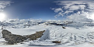
panorama
gallery
Piz Cartas, recorded by Piz Martegnas
Sur Carungas , recorded by Piz Cartas
literature
- Manfred Hunziker: Club Guide, Bündner Alpen, Volume 3 (obverse) 1st edition. Verlag des SAC, 1994, ISBN 3-85902-140-0 , p. 292.


