
Piz Arblatsch
| Piz Arblatsch | ||
|---|---|---|
 Piz Arblatsch, Piz Forbesch and Piz Platta (from left to right) |
||
| height | 3203 m above sea level M. | |
| location | Canton of Graubünden , Switzerland | |
| Mountains | Oberhalbsteiner Alps | |
| Dominance | 2.08 km → Piz Forbesch | |
| Notch height | 292 m ↓ ridge between Piz Arblatsch and Piz Forbesch | |
| Coordinates | 764000 / 156035 | |
|
||
| First ascent | May 21, 1893 by Valentin Fynn, Walter Gröbli and Christian Klucker | |
| Normal way | Through the south couloir | |
 Steinmann on the Piz Arblatsch |
||

The Piz Arblatsch (probably from the Latin albuluceus , a derivation of albus for white ) is a mountain west of Mulegns in the canton of Graubünden in Switzerland with a height of 3203 m above sea level. M. It forms the opposite pole of Piz Forbesch ( 3261.8 m ), which appears from most angles as the northern culmination of the massif . Thanks to its dominance , Piz Arblatsch offers an exceptional view of the Bernese and Valais Alps ( Schreckhorn , Eiger , Mönch , Finsteraarhorn , Dom or the border summit 147.64 km away ) , especially to the west . The summit is surrounded by several almost equally high rock heads (see gallery).
Location and surroundings

The Piz Arblatsch is the namesake of the Forbesch-Arblatsch massif , a subgroup of the Oberhalbsteiner Alps . The municipal boundaries between Riom-Parsonz , Mulegns and Savognin met at the summit ; today the mountain lies entirely within the territory of the municipality of Surses . The Piz Arblatsch is bordered in the south by the Val Faller , in the northeast by the Val da Livizung and in the west by the Val Curtegns , a side valley of the Val Nandro . All valleys are side valleys of the Oberhalbstein .
The neighboring peaks include the Piz Arlos , the Piz Spegnas , the Piz Forbesch and the Piz Mez .
The farthest visible point ( 44 ° 14 '2.1 " N , 7 ° 12' 47.5" O ) is from Piz Arblatsch the Rocca Pan PERDU, 31 km south west of Cuneo in the Italian region Piedmont , just before the border with France and is 316 km away. From Piz Arblatsch it is located in a south-south-west direction, immediately to the left of Piz Forbesch.
The valley location is Mulegns. Common starting points are radons and tga.
Routes to the summit
Through the south couloir (also possible with skis in winter)
Danger of falling rocks in the couloir
- Starting point: Tga ( 1927 m ) or Mulegns ( 1482 m )
- Difficulty: WS-
- Time required: 4 hours from Tga or 5¾ hours from Mulegns
Over the southwest ridge
- Starting point: Tga ( 1927 m ) or Mulegns ( 1482 m )
- Difficulty: WS
- Time required: 4 hours from Tga or 5¾ hours from Mulegns
From Piz Forbesch
Danger of falling rocks in the couloir
- Starting point: Piz Forbesch ( 3261.8 m )
- Difficulty: WS-
- Time required: 2 hours
Over the north ridge
Ticklish in wet and snowy flanks
- Starting point: Piz Arlos ( 2696.6 m ), Radons ( 1893 m ), Alp Tarvisch ( 1936 m ) or Savognin ( 1207 m )
- Difficulty: WS
- Time required: 3½ hours from Piz Arlos, 5 hours from Radons, 4 hours from Alp Tarvisch or 6 hours from Savognin
Over the east ridge
Ticklish in wet and snowy flanks
- Starting point: Tga ( 1927 m ), Mulegns ( 1482 m ), Alp Tarvisch ( 1936 m ) or Savognin ( 1207 m )
- Route: Via Fuorcla da Spegnas ( 2653 m )
- Difficulty: ZS
- Time required: 5½ hours from Tga, 6½ hours from Mulegns, 5¾ hours from Alp Tarvisch or 7¾ hours from Savognin
panorama

gallery

Piz Arblatsch, surrounded by several almost equally high rock heads

Piz Arlos, Piz Arblatsch and Piz Forbesch (from left to right) recorded by Riom-Parsonz

Piz Forbesch and Piz Arblatsch (from left to right) taken from Piz Barscheinz

View to the north to the Sotgôt (the lower part of the Oberhalbstein ) and Lenzerheide
Black to the northwest on radons in the Val Nandro

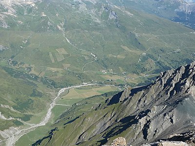
View to the south on Tga in Val Faller

View to the east of the Alp Flix

View to the south of Piz Platta (left) and Piz Forbesch (right)


_as_seen_from_Piz_Arblatsch.jpg)


literature
- Manfred Hunziker: Club Guide, Bündner Alpen, Volume 3 (obverse) 1st edition. Verlag des SAC, 1994, ISBN 3-85902-140-0 , pp. 265-269.
- National map of Switzerland, sheet 1256 Bivio, 1: 25000, Federal Office of Topography, edition 2003
Web links
- Calculated 360 ° panorama from Piz Arblatsch
- www.hikr.org Various tour reports
- www.summitpost.org Tourism
Individual evidence
- ↑ Andrea Schorta: How the mountain got its name . Small Rhaetian name book with two and a half thousand geographical names of Graubünden. Terra Grischuna Verlag, Chur and Bottmingen / Basel 1988, ISBN 3-7298-1047-2 , p. 63 .
- ↑ Calculated 360 ° panorama ( U. Deuschle ; information ) from Piz Arblatsch