
Piz Arlos
| Piz Arlos | ||
|---|---|---|
 Piz Arlos, recorded by Furschela digl Arlos |
||
| height | 2696.6 m above sea level M. | |
| location | Canton of Graubünden , Switzerland | |
| Mountains | Oberhalbsteiner Alps | |
| Dominance | 0.3 km → ridge towards Piz Arblatsch | |
| Notch height | 17 m ↓ ridge towards Piz Arblatsch | |
| Coordinates | 764 475 / 158 639 | |
|
||
| Normal way | About Tscharnoz | |
 Piz Arlos, Piz Arblatsch and Piz Forbesch (from left to right), taken by Riom-Parsonz |
||

The Piz Arlos is a mountain in the canton of Graubünden in Switzerland with a height of 2696.6 m above sea level. M. and is located south of Savognin and west of Rona . The elevation is located on the north ridge of Piz Arblatsch ( 3203 m above sea level ), 2.64 km north-northeast of the summit. The Piz Arlos is not the highest point of the ridge, but the ridge drops continuously to the north. Furschela digl Arlos (P.2420.8 on the national map) north of Piz Arlos is the end point of the ridge. On the connecting ridge to Piz Arblatsch there is an old cross and a summit book south of Piz Arlos at P. 2863 on the map. All three ridge elevations offer an excellent view of the various villages in the Savognin basin, of the opposite south faces of the Bergüner Stocks ( Piz Mitgel , Tinzenhorn and Piz Ela ) and of the Piz d'Err group . The Furschela digl Arlos is a worthwhile excursion destination, which can sometimes be reached on skis from Rona even in winter.
Location and surroundings
The Piz Arlos belongs to the Forbesch-Arblatsch massif , a sub-group of the Oberhalbsteiner Alps . The summit is located entirely within the municipality of Surses .
The neighboring peaks include the Piz Spegnas , the Piz Arblatsch and the Piz Mez .
Valley locations are Rona, Tinizong and Savognin. A frequent starting point is the end of the street near Tarvisch.
Routes to the summit
About Tscharnoz
- Starting point: Savognin ( 1207 m ) or the end of the road at Tarvisch ( 1803 m )
- Difficulty: EB
- Time required: 4¼ hours from Savognin or 2¼ hours from the end of the road at Tarvisch (up to Furschela digl Arlos each ¾ hours less)
panorama

gallery

Savognin, in the background Piz Arlos
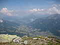
Sotgôt and Lenzerheide, taken from Piz Arlos

Ridge to Piz Arblatsch with P.2863, taken from Piz Arlos
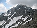
Piz Arblatsch, taken from P.2863, which is located on the ridge between Piz Arlos and Piz Arblatsch
Forbesch-Arblatsch massif, taken from Sur Carungas

Piz Arlos, recorded in Savognin


literature
- Manfred Hunziker: Club Guide, Bündner Alpen, Volume 3 (obverse) 1st edition. Verlag des SAC, 1994, ISBN 3-85902-140-0 , p. 271.
- National map of Switzerland, sheet 1236 Savognin, 1: 25000, Federal Office of Topography, 2003 edition