
Piz Forbesch
| Piz Forbesch | ||
|---|---|---|
 Piz Forbesch, taken from Piz Mez |
||
| height | 3261.8 m above sea level M. | |
| location | Canton of Graubünden , Switzerland | |
| Mountains | Oberhalbsteiner Alps | |
| Dominance | 3.6 km → Piz Platta | |
| Notch height | 604 m ↓ Fuorcla Curtegns | |
| Coordinates | 762 697 / 154 309 | |
|
||
| First ascent | Main summit: May 21, 1893 by Valentin Fynn, Walter Gröbli and Christian Klucker . Piz Forbesch Pintg: April 10, 1893 by Walter Gröbli with Johann Signorell. |
|
| Normal way | Over the northeast ridge | |
 Steinmann on the Piz Forbesch. |
||

The Piz Forbesch ( Rhaeto-Romanic , in the idiom Surmiran from the Latin forfex for 'scissors') is a mountain west of Mulegns in the canton of Graubünden in Switzerland with a height of 3261.8 m above sea level. M. Thanks to the deep-cut notch between Piz and Piz Forbesch Forbesch Pintg ( 3202 m ) to the south, the mountain gets the form of a pair of scissors and is easy to identify. Pintg is Rhaeto-Romanic for 'small'. Thanks to the dominance of Piz Forbesch, it offers an exceptional view of the Bernese and Valais Alps ( Mönch , Dufourspitze or the Weisshorn, 149.5 km away ) , especially to the west . The farthest visible point ( 44 ° 18 '33 " N , 6 ° 57' 39.4" O ) from Piz Forbesch is located in the vicinity of the Monte Vallonetto on the boundary between the Italian Piedmont and the French region Provence-Alpes -Côte d'Azur and is 319 km away.
Location and surroundings

The Piz Forbesch is the highest peak of the Forbesch-Arblatsch massif , a sub-group of the Oberhalbsteiner Alps . A long north ridge connects the Piz Forbesch with the Piz Arblatsch . The regular ridge descends over a distance of around 1.5 km in a few steps to the deepest point ( 2968 m ), from where it climbs over several peaks to Piz Arblatsch 600 m away. Because of the loose and flat rocks near the deepest point, the ridge is rarely used.
The south and west faces of Piz Forbesch Pintg both fall very steeply, with brittle rock offering considerable resistance to attempts to climb. From the southern foot of Piz Forbesch Pintg, the very pronounced main ridge runs flat to the elevation P. 2954 above Fuorcla Cagniel, from where, turning slightly to the south, it slopes down as a rib to Val Gronda . To the west it forms a rock face that can hardly be overcome, which is why there is no access to Piz Forbesch Pintg from Fuorcla Cagniel.
The municipal boundary between the former municipalities of Riom and Mulegns, which have both belonged to the municipality of Surses since 2016 , ran above the peaks .
The neighboring peaks include the Piz Arblatsch, Piz Platta , Piz Cagniel and Piz Mez .
The valley location is Mulegns. Common starting points are radons and tga.
Pawn rule
A widespread, Romanesque peasant rule in Oberhalbstein says: Mett'igl Piz Forbesch se igl tgappi, lascha la fotsch e pegl'igl rasti , which means something like “If Piz Forbesch puts on a cap, leave the scythe and take the rake ». This means that bad weather follows when Piz Forbesch is cloudy.
Routes to the summit
The alpine road from Mulegns into Val Faller to Tga is closed to general motor vehicle traffic. However, a hiking bus runs every Thursday from Savognin to Val Faller.
Main summit
Over the northeast ridge
- Starting point: Tga ( 1927 m ) or Mulegns ( 1482 m )
- Via: head in front of the large gutter, past P.3176
- Difficulty: T5 + , II , WS
- Time required: 4 hours from Tga or 5¾ hours from Mulegns
Through the large south wall channel
- Starting point: Tga ( 1927 m ) or Mulegns ( 1482 m )
- Via: Past P. 3176
- Difficulty: T5 + , II , WS
- Time required: 4 hours from Tga or 5¾ hours from Mulegns
Through the northwest wall
- Starting point: Radons ( 1866 m )
- Via: head in front of the large gutter, past P.3176
- Difficulty: ZS
- Time required: 5½ hours
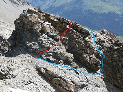
Route at key point 1, head in front of the large gully that you bypass in the southeast face.

Route at key point 2, P.3176, which you avoid in slate rubble volumes of the steep northwest flank.

The large south wall channel.


Piz Forbesch Pintg
Contrary to what the name suggests, there is no sharp edge of the ridge rising from the notch to Piz Forbesch Pintg, but a slope made up of bands of rock and rubble.
Over the north ridge
- Starting point: Mulegns ( 1482 m ), Tga ( 1927 m ) or Radons ( 1866 m )
- Via: Forbeschscharte
- Difficulty: WS
- Time required: 6 hours from Mulegns, 4¼ hours from Tga or 4½ hours from Radons
- Note: If the couloir is dry, it is more difficult and tedious to walk through the ascent because of the large amount of loose material than if the snow is good.
Through the eastern flank
- Starting point: Mulegns ( 1482 m ) or Tga ( 1927 m )
- Difficulty: WS
- Time required: 5¾ hours from Mulegns, 4 hours from Tga

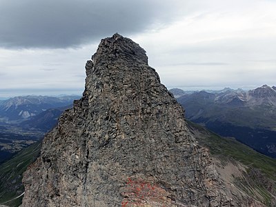
Summit of Piz Forbesch Pintg.

Piz Forbesch Pintg and Forbeschscharte, taken from the main summit.


panorama


gallery

Aerial view from Piz Forbesch.

Piz Arblatsch , Piz Forbesch and Piz Platta , recorded by Piz Martegnas .
View from Piz Forbesch Pintg to the 60 m higher Piz Forbesch.

View into Val Nandro ( Savognin ski area ), Oberhalbstein and Lenzerheide .


literature
- Manfred Hunziker: Club Guide, Bündner Alpen, Volume 3 (obverse) 1st edition. Verlag des SAC, 1994, ISBN 3-85902-140-0 , pp. 262-265.
- Fabian Lippuner, David Coulin: Alpine hiking / summit destinations, Graubünden North. Verlag des SAC, 2013, ISBN 978-3-85902-341-3 , pp. 152–155.
- National map of Switzerland, sheet 1256 Bivio, 1: 25000, Federal Office of Topography, edition 2003
Web links
- Calculated 360 ° panorama from Piz Forbesch
- www.hikr.org Various tour reports
Individual evidence
- ↑ Andrea Schorta: How the mountain got its name . Small Rhaetian name book with two and a half thousand geographical names of Graubünden. Terra Grischuna Verlag, Chur and Bottmingen / Basel 1988, ISBN 3-7298-1047-2 , p. 88 .
- ↑ Calculated 360 ° panorama ( U. Deuschle ; information ) from Piz Forbesch
- ↑ Bike & hiking bus timetable on the Savognin Bivio Albula holiday region website, accessed on April 8, 2018