
Piz digl Gurschus
| Piz digl Gurschus | ||
|---|---|---|
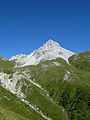
 Piz digl Gurschus, taken from the Pass da Schmorras |
||
| height | 2880 m above sea level M. | |
| location | Canton of Graubünden , Switzerland | |
| Mountains | Oberhalbsteiner Alps | |
| Dominance | 3.38 km → Piz Grisch | |
| Notch height | 250 m ↓ Between Pass da Surcarungas and Pass Colmet | |
| Coordinates | 757 488 / 158 585 | |
|
||
 Summit head of the east summit, taken from the northwest |
||

The Piz digl Gurschus is a rocky ridge east of Ausserferrera in the canton of Graubünden in Switzerland with an altitude of 2880 m above sea level. M. The map lists three peaks: the east summit ( 2880 m ), the middle summit ( 2844 m ) and the west summit ( 2753 m ).
Surname
The name Gurschus probably goes back to gruscha ( Rhaeto-Romanic in the idiom Sutselvisch for mange, rash, scabies ), which was carried over to bad pasture etc. In the first edition of the guide, Piz digl Gurschus was still referred to as the gruesome one. The mountain is chopped up and crumbly and its flanks are furrowed by several gullies. The extensive scree slopes at the foot of the mountain reveal the poor quality of the rocks and make the approach difficult. The climbing in the brittle, loose rocks in many places no longer corresponds to today's taste.
Location and surroundings
The Piz digl Gurschus belongs to the Piz Curvér group , a subgroup of the Oberhalbsteiner Alps . The summit is located in the municipality of Ferrera GR . The Piz digl Gurschus is located between the Alp Lambegn in the north and the Alp Mos in the south. To the east of the summit are the saddles Furcletta digl Gurschus and Furcletta dil Carpeder ( 2703 m ), to the southeast the Pass da Schmorras ( 2564 m ).
The neighboring peaks include the Sur Carungas , the Piz Settember , the Piz Alv , the Piz Grisch , the Nolla and the Piz la Tschera .
The valley location is Ausserferrera . Frequent starting points are Bärenburg, Andeer and Radons in the Val Nandro .
Routes to the summit
East summit
Over the northeast slope
- Starting point: Andeer ( 982 m ), Bärenburg ( 1047 m ) or Ausserferrera ( 1300 m )
- Via: Alp Lambegn
- Difficulty: WS
- Time required: 5¼ hours from Andeer, 5 hours from Bärenburg or 4¾ hours from Ausserferrera
Over the east ridge
- Starting point: Andeer ( 982 m ), Bärenburg ( 1047 m ), Ausserferrera ( 1300 m ) or Radons ( 1866 m )
- Via: Furcletta dil Carpeder
- Difficulty: ZS
- Time required: 6 hours from Andeer, 5¾ hours from Bärenburg, 4¾ hours from Ausserferrera, 3¼ hours from Radons or ½ hour from the Furcletta dil Carpeder
Central summit
Through the southeast wall
- Starting point: Ausserferrera ( 1300 m ) or Radons ( 1866 m )
- Via: Pass da Schmorras
- Difficulty: WS +
- Time required: 5 hours from Ausserferrera, 3½ hours from Radons or 1 hour from Pass da Schmorras
West summit
Through the north flank
- Starting point: Andeer ( 982 m ), Bärenburg ( 1047 m ) or Ausserferrera ( 1300 m )
- Via: Nolla ( 2641 m )
- Difficulty: WS
- Time required: 6 hours from Andeer, 5¾ hours from Bärenburg, 4½ hours from Ausserferrera or ¾ hours from Nolla
panorama

gallery

Steinmann on Piz digl Gurschus

Piz digl Gurschus and cows, taken from Alp Schmorras.

Piz digl Gurschus, taken from Alp Andies.
Piz digl Gurschus, taken from Tgavaglia.

View of the Bergüner Stocks ( Piz Mitgel , Tinzenhorn and Piz Ela from left to right).
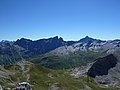
View of Piz Arblatsch , Piz Forbesch and Piz Platta (from left to right).

View of Piz Grisch .

View of Piz la Tschera .


literature
- Manfred Hunziker: Club Guide, Bündner Alpen, Volume 3 (obverse) 1st edition. Verlag des SAC, 1994, ISBN 3-85902-140-0 , pp. 289-291.
- National map of Switzerland, sheet 1235 Andeer, 1: 25000, Federal Office of Topography, 2009 edition
Web links
- Panorama from Piz digl Gurschus
- www.hikr.org Tour reports