Motta Vallac
| Motta Vallac | ||
|---|---|---|
|
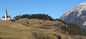
The Motta Vallac with the Church of Salouf |
||
| height | 1375 m above sea level M. | |
| location | Canton of Graubünden , Switzerland | |
| Mountains | Oberhalbsteiner Alps | |
| Dominance | 0.568 km | |
| Notch height | 36 m ↓ Del | |
| Coordinates | 763 646 / 167195 | |
|
|
||
The Motta Vallac ( Rhaeto-Romanic in the idiom Surmiran , motta from the Gallic motta for 'earth mound' and Vallac a derivation of aual from the Latin aqualis for 'moat') is a hilltop north of Salouf in Oberhalbstein in the canton of Graubünden in Switzerland . It seals off the Julia valley from that of the Albula with Tiefencastel as a crossing point. The apex of the ridge reaches 1375 m above sea level. M. Significant prehistoric excavations have been carried out on the Motta Vallac .
Location and surroundings
The Motta Vallac is located in the municipality of Surses , north of the village of Salouf and southeast of the hamlet of Del . It marks the lower end of the upper half stone . Towards the east, the Motta Vallac falls 320 m down to the Julia, which is deeply eroded in this section. On the other side of the valley which is Conterser stone ( Romansh Crap Ses , 764 310 / one hundred sixty-seven thousand two hundred and fourteen ) that serves as the namesake of itself orographic located above the valley Oberhalbstein (Romanesque Surses acts).
The Motta Vallac can easily be reached from the church of Salouf in 20 minutes or from the road towards Del in 15 minutes.
Prehistoric excavations
Walo Burkart discovered the first excavation objects on Motta Vallac in 1941. In 1945/1946 he then tried to find out more by means of further exploratory cuts . A preliminary test excavation and several area excavations by the archaeological department of the Swiss National Museum extended with interruptions over the period from 1972 to 1979.
They led to the establishment of an early Bronze Age foundation horizon (2150 ± 90 BC), Middle and Late Bronze Age settlement remains and finds, as well as industrial facilities and, after an interruption lasting several centuries, a renewed presence of residents during the late Latène period and the first century AD . The foundations of a rectangular tower measuring approximately 10.5 by 9 meters were secured in the center of the plateau from late Roman times. In the high Middle Ages, a fortification system in the form of a wooden structure and a palisade with rampart and moat was built on the site of the tower in the west of the system. The iron finds date from the period between 1000 and 1200. As the latest evidence of human presence, a farm was identified that was destroyed when the Confederation was founded . Since this type of system does not exist in the rest of the Bündnerland, influences from the northern Alpine foothills are suspected.
There are no documented references to builders and residents. Members of the noble families of Salouf such as Egino, Adeletta or Ludwig between 1141 and 1160 are conceivable. Fortunat Sprecher mentions the castle in his chronicle in 1617 as ... vester Turn called Valatschia ...
The multiple colonization of the Motta Vallac led to a complex, often not very pronounced stratification; this was also characterized by the erosion of layers as a result of human and natural influences. The complex genesis of layers and the many interventions that took place in them at different times, such as the creation of hearth pits, post holes and trenches, often faced insoluble problems of chronological assignment of individual findings. The support by the Physics Institute of the University of Bern via radiocarbon data was therefore an invaluable aid in evaluating the excavation results.
Web links
- Motta Vallac on the ETHorama platform
- Panorama from the Motta Vallac
Individual evidence
- ↑ Andrea Schorta: How the mountain got its name . Small Rhaetian name book with two and a half thousand geographical names of Graubünden. Terra Grischuna Verlag, Chur and Bottmingen / Basel 1988, ISBN 3-7298-1047-2 , p. 107 .
- ↑ Andrea Schorta: How the mountain got its name . Small Rhaetian name book with two and a half thousand geographical names of Graubünden. Terra Grischuna Verlag, Chur and Bottmingen / Basel 1988, ISBN 3-7298-1047-2 , p. 64 & 148 .
- ↑ Otto P. Clavadetscher & Werner Meyer : Das Burgenbuch von Graubünden, p. 71
- ^ René Wyss: The hill settlement Motta Vallac in Oberhalbstein (Salouf GR) . Ed .: ETH Zurich. tape 5 , no. 2 . Archeology of Switzerland = Archeology suisse = Archeologia svizzera, Zurich 1982, p. 76-82 , doi : 10.5169 / seals-4391 .


