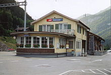
Tiefencastel
| Tiefencastel | ||
|---|---|---|
| State : |
|
|
| Canton : |
|
|
| Region : | Albula | |
| Political community : | Albula / Alvra | |
| Postal code : | 7450 | |
| former BFS no. : | 3505 | |
| Coordinates : | 763 249 / 170416 | |
| Height : | 859 m above sea level M. | |
| Area : | 14.85 km² | |
| Residents: | 247 (December 31, 2014) | |
| Population density : | 17 inhabitants per km² | |
| Website: | www.albula-alvra.ch | |
|
Tiefencastel |
||
| map | ||
|
|
||
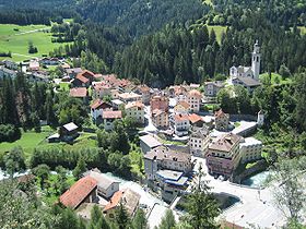
Tiefencastel ( Grisons German [ tyfɐˈk (h) aʃtɐ ], Rhaeto-Romanic Casti [ kɐʃtˈi ]) is a place in the municipality of Albula / Alvra in the canton of Graubünden in Switzerland .
Until December 31, 2014, Tiefencastel was an independent political municipality and capital of the then Alvaschein district and the Albula district . On January 1st, 2015 it merged with the municipalities of Alvaneu , Alvaschein , Brienz / Brinzauls , Mon , Stierva and Surava .
coat of arms
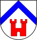
Blazon : In silver (white) under a blue rafter a two-tower red castle with battlements and gate
The coat of arms illustrates the name of the former municipality with the castle symbol placed in the lower area of the shield . It refers to the medieval castle that was once located on today's Suloms church hill . Above it, the coat of arms symbolically shows the confluence of the Albula (right) and Julia (left) in the form of a blue rafter. The colors go back to the coat of arms of the Lords of Vaz .
geography
Tiefencastel is located in the Albula Valley at the foot of the Albula and Julier Alpine passes in a basin at an altitude of 851 m above sea level. M. (Albula Bridge). The lowest point of the former municipal area is at the influence of the Niselas reservoir at 825 m , the highest point 200 meters northwest of Piz Mitgel at almost 3100 m . In Tiefencastel the river Julia flows into the Albula .
According to the cantonal area statistics from 1997, the former municipal area consists of: 302 hectares (20%) of usable agricultural area, 736 hectares (50%) forest, 46 hectares (3%) settlement area and 401 hectares (27%) unproductive area. The agricultural area can be divided into 116 hectares of meadow and arable land and 186 hectares of alpine agricultural area.
The village lies on the Albula line of the Rhaetian Railway. The Tiefencastel train station is also the feeder for the Oberhalbstein .
The neighboring villages of Tiefencastel are Lantsch / Lenz , Brienz / Brinzauls , Surava , Cunter , Salouf , Mon , Stierva and Alvaschein .
history
Tiefencastel was first mentioned in 831 as a villa in Castello Impitinis with the seat of the royal administrator. The name should face dispensation from lat. Imus , bottom, lowest, on the base 'and in several Grisons field names appearing pre-Roman word * Pitino , castle, Wehranlag' decline, illustrated by Lat. Castellum , castle, fortress' that the name later replaced and so led to the Romanesque form of the name Castí . Around 1300 the name Īmum Castellum * is documented (1297 Petro de Imo Castello ; 1311 tres de Ymocastello ... in Ymo Castello ), from which the German name was probably formed (1357 Tieffenchastl ; based on box 1389 zů dem Tieffenchasten , 1499 Tufenkasten which lives on in the German dialect form).
On the hill of Plattas there was a Bronze Age settlement and on the church hill the Roman fort . Archaeological finds confirm the pre-Christian settlement. In the early Middle Ages, Tiefencastel was a fortified settlement. In the Middle Ages the place even had a customs bridge. From 960 Tiefencastel was episcopal territory and thus passed as a fief to the Vazer and other local vassals. After the middle of the 16th century, the Tiefencastel court with the neighborhoods Alvaschein and Mon was part of the Oberhalbstein High Court in the Church of God .
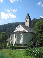
At today's wayside shrine on Julierstrasse above the village, it was in the 6./7. Chapel of St. Ambrosius (Romansh Sontg Ambriesch) built in the 16th century. For centuries this served as the parish church of Tiefencastel, partly also of Alvaschein. In 1343, today's St. Stephen's Church was first mentioned as "super colle sancti Stephani". It ousted St. Ambrose as the official parish church. From 1635 Italian Capuchins took over the pastoral care of Tiefencastel. The hospice became the starting point for the Counter-Reformation in Central Grisons. In 1650–1663 the church of St. Stephen was rebuilt by the Capuchins and decorated with significant carvings and paintings. The church has been preserved in this form to this day.
On May 11, 1890, a major fire destroyed large parts of the village. 24 houses, 34 stable buildings and parts of the church and the steeple were affected. In terms of traffic, Tiefencastel has always been of great importance, because the place is on the transit axis over the Septimer and Julier passes. The Septimerpass road to Chiavenna was for centuries the most important traffic axis for crossing the Alps. After the expansion of the pass paths, a horse post station was set up in Tiefencastel in 1835. From 1898 the network of the Rhaetian Railway was opened up. In 1903 the Chur-St.Moritz line was opened. The Tiefencastel train station brought the town back to life. Starting in 1999, a village bypass brought relief for the village, which was suffering from enormous through traffic.
population
| Population development | ||||||||
|---|---|---|---|---|---|---|---|---|
| year | 1850 | 1880 | 1900 | 1950 | 1980 | 1990 | 2000 | 2014 |
| Residents | 135 | 209 | 257 | 327 | 277 | 239 | 230 | 247 |
Originally, the entire population spoke the Romance dialect Surmiran . In 1880 it was 89% and in 1910 80%. Since the inter-war period, the proportion fell to 53% in 1970. Today, German and Romansh are the official languages.
| Languages in Tiefencastel | ||||||
|---|---|---|---|---|---|---|
| languages | 1980 census | 1990 census | 2000 census | |||
| number | proportion of | number | proportion of | number | proportion of | |
| German | 138 | 49.82% | 113 | 47.28% | 134 | 58.26% |
| Romansh | 124 | 44.77% | 102 | 42.68% | 87 | 37.83% |
| Italian | 9 | 3.25% | 9 | 3.77% | 3 | 1.30% |
| Residents | 277 | 100% | 239 | 100% | 230 | 100% |
80% of the population professes the Roman Catholic and 13% the Evangelical Reformed faith (2000 census). 86% of the population are Swiss citizens. (December 2005)
tourism
Tiefencastel has long been a popular stage destination for pass drivers due to its geographical location. Renowned gastronomy has developed in the branching off of the two passes. Tiefencastel is increasingly being used as a holiday resort for families and those who do sports. In the nearby Alvaneu Bad there is a thermal bath and an alpine golf course (18 holes). The ski resorts of Lenzerheide , Savognin and Davos are easily accessible from Tiefencastel.
Attractions
- The Carolingian Church of St. Peter Mistail (built approx. 806) 1.5 kilometers northwest of Tiefencastel is world-class.
- Catholic Church of St. Stephen
- Roman finds in Crap Ses
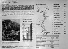
- Another attraction is the Albula line of the Rhaetian Railway, which can also be viewed on foot on its most interesting part on a well-marked railway hiking trail. With its countless bridges, spiral and circular tunnels, this railway line is one of the greatest engineering masterpieces in Europe. In July 2008 the UNESCO World Heritage Committee decided to add the Albula and Bernina railway lines to the list of world cultural heritage .
Tiefencastel also offers numerous other attractive hiking opportunities (e.g. into Val Tuors or Oberhalbstein ). The Ziteil pilgrimage church is located above Salouf , not far from Tiefencastel . With a height of 2429 m above sea level. M. Ziteil is the highest place of pilgrimage in the Eastern Alps (cf. Rocciamelone ).
economy
From 1850 onwards, the first hotel buildings, which mainly accommodated passers-by, brought additional income to the originally agricultural town. Tiefencastel was the most important cattle market in the region until 1950. Today the village primarily owns small businesses and services. In 1949, the power station of the city of Zurich (EWZ) put the Tiefencastel-West power plant ( Burvagn -iefencastel level) and in 1971 the Tiefencastel-Ost power plant ( Marmorera - Tinizong- Tiefencastel level) into operation. In 1990 the Albula-Landwasser Kraftwerke (ALK) opened the Filisur-Tiefencastel headquarters.
Of the 223 employees, 5% work in agriculture and forestry. 35% work in industrial and manufacturing businesses and 60% in service companies. (December 2005)
literature
- Erwin Poeschel : The art monuments of the canton of Graubünden II. The valley communities Herrschaft, Prättigau, Davos, Schanfigg, Churwalden, Albula valley. (= Art Monuments of Switzerland. Volume 9). Edited by the Society for Swiss Art History GSK. Bern 1937. DNB 811066703 .
- Gion Peder Thöni: Tiefencastel. In: Historical Lexicon of Switzerland . 2016 .
Web links
- Tiefencastel on the ETHorama platform
Individual evidence
- ↑ a b Gunhild Hoyer / Andres Kristol: Tiefencastel GR (Albula) in: Dictionnaire toponymique des communes suisses - Lexicon of Swiss community names - Dizionario toponomastico dei comuni svizzeri (DTS | LSG). Center de dialectologie, Université de Neuchâtel, Verlag Huber, Frauenfeld / Stuttgart / Vienna 2005, ISBN 3-7193-1308-5 and Éditions Payot, Lausanne 2005, ISBN 2-601-03336-3 , p. 874.
- ^ Catholic Church of St. Stephen
- ↑ Crap Ses on ETHorama
