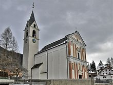
Cunter
| Cunter | |
|---|---|
| State : |
|
| Canton : |
|
| Region : | Albula |
| Political community : | Surses |
| Postal code : | 7452 |
| former BFS no. : | 3532 |
| Coordinates : | 764 956 / 164012 |
| Height : | 1182 m above sea level M. |
| Area : | 7.12 km² |
| Residents: | 256 (December 31, 2014) |
| Population density : | 36 inhabitants per km² |
| Website: | www.surses.ch |
|
Cunter |
|
| map | |
Cunter ( German and until 1943 Conters in Oberhalbstein ) was until December 31, 2015 a political municipality in the Surses district in the Albula district of the canton of Graubünden in Switzerland . On January 1, 2016, Cunter merged with the municipalities of Bivio , Marmorera , Mulegns , Riom-Parsonz , Salouf , Savognin , Sur and Tinizong-Rona to form the new municipality of Surses .
coat of arms
Blazon : In gold (yellow) the red bust of St. Charles Borromeo
The motif of the coat of arms is the patron of the local parish church.
geography

Cunter is a former municipality in the Oberhalbstein region and is located on the right bank of the Julia on the road from Tiefencastel to Silvaplana (the Julier pass road). In addition to the village, the hamlet of Burvagn and the Mäiensässen Muntschect and Promastgel also belong to the village. Of the entire former community area of 711 hectares, 355 hectares are covered by forest and wood. At least 230 hectares can be used for agriculture - the majority of it, however, are alpine farms. Another 108 hectares are unproductive areas (mostly mountains) and 18 hectares are settlement areas. Cunter borders on Riom-Parsonz , Salouf , Savognin and Albula / Alvra .
population
| year | 1850 | 1900 | 1950 | 1970 | 1980 | 1990 | 2000 | 2005 | 2014 |
|---|---|---|---|---|---|---|---|---|---|
| Residents | 182 | 152 | 152 | 116 | 141 | 175 | 198 | 215 | 256 |
languages
The original language is Surmeir , a regional dialect of Graubünden Romance . The former municipality remained almost monolingual in Romansh until 1970. While in 1880 86.4% said this language was their mother tongue, in 1910 it had risen to 95.39%. In 1941 it was still 86.4% and in 1970 it was 87.93%. Since then, there has been an increased change of language to German, which can be attributed to immigration. This is shown in the table below:
| languages | 1980 census | 1990 census | 2000 census | |||
|---|---|---|---|---|---|---|
| number | proportion of | number | proportion of | number | proportion of | |
| German | 27 | 19.15% | 54 | 30.86% | 72 | 36.36% |
| Graubünden Romance | 105 | 74.47% | 95 | 54.29% | 101 | 51.01% |
| Italian | 8th | 5.67% | 9 | 5.14% | 11 | 5.56% |
| Residents | 141 | 100% | 175 | 100% | 198 | 100% |
The official language is the Graubünden Romance language.
Origin and nationality
Of the 215 residents at the end of 2005, 184 (= 85.58%) are Swiss citizens.
Attractions
Catholic parish church of St. Karl Borromeo
literature
- Erwin Poeschel : The art monuments of the canton of Graubünden III. The valley communities Räzünser Boden, Domleschg, Heinzenberg, Oberhalbstein, Upper and Lower Engadine. (= Art Monuments of Switzerland. Volume 11). Edited by the Society for Swiss Art History GSK. Bern 1940. DNB 760079625 .
- Gion Peder Thöni: Cunter. In: Historical Lexicon of Switzerland . 2016 .
Web links
- Cunter on the ETHorama platform
- Page about Cunter on the website of the Savognin tourist region


