
Mon GR
| GR is the abbreviation for the canton of Grisons in Switzerland and is used to avoid confusion with other entries of the name Mon to avoid. |
| Mon | ||
|---|---|---|
 |
||
| State : |
|
|
| Canton : |
|
|
| Region : | Albula | |
| Political community : | Albula / Alvra | |
| Postal code : | 7458 | |
| former BFS no. : | 3502 | |
| Coordinates : | 762 606 / 168 730 | |
| Height : | 1231 m above sea level M. | |
| Area : | 8.46 km² | |
| Residents: | 79 (December 31, 2014) | |
| Population density : | 9 inhabitants per km² | |
|
Proportion of foreigners : (residents without citizenship ) |
0.0% (2,011) | |
| Website: | www.albula-alvra.ch | |
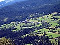
 Mon, view from the south |
||
| map | ||
|
||

Mon ( German and officially Mons until 1943 ) is a village in the Swiss canton of Graubünden in the municipality of Albula / Alvra , which belongs to the Alvaschein district in the Albula district.
Until December 31, 2014 Mon was an independent political municipality . On January 1, 2015, it merged with the communities of Alvaneu , Alvaschein , Brienz / Brinzauls , Stierva , Surava and Tiefencastel to form the new community of Albula / Alvra .
coat of arms
Blazon : In red over a silver (white) two-pointed mountain a flying silver dove with a golden (yellow) chip in its beak
The dove is the coat of arms of the Pfäfers monastery and refers to its founding legend. The Zweispitzberg should refer to the name of the former municipality (mountain).
geography


The place is a clustered village above the Julia and is on the northeast slope of Piz Curvér southwest of Tiefencastel . Of the entire former municipal area of 851 hectares, 500 hectares are covered by forest and wood. Another 312 hectares can be used for agriculture. In addition to 23 ha of unproductive area (mountains), the former municipal area also comprises 16 ha of settlement area. The former community includes Maiensasses such as Zozas .

Parish Church of St. Francis
View from the south


population
languages
Up until the time before the Second World War, Mon was only spoken in Romansh. The inhabitants speak Surmeir . In 1880 it was 100%, in 1941 it was 96%. The Rhaeto-Romanic share has been falling since 1970. The only official language of the former municipality is Romansh to this day.
| Languages in Mon | ||||||
| languages | 1980 census | 1990 census | 2000 census | |||
| number | proportion of | number | proportion of | number | proportion of | |
| German | 14th | 21.21% | 19th | 28.36% | 39 | 45.35% |
| Romansh | 52 | 78.79% | 48 | 71.64% | 45 | 52.33% |
| Residents | 66 | 100% | 67 | 100% | 86 | 100% |
Origin and nationality: At the end of 2005, 87 of the 91 residents were Swiss citizens.
Attractions
- Former Catholic parish church of St. Cosmas and Damian , below the village, paintings from the 15th century. Parish church of St. Cosmas and Damian
- Catholic parish church of St. Francis
literature
- Erwin Poeschel : The art monuments of the canton of Graubünden II. The valley communities Herrschaft, Prättigau, Davos, Schanfigg, Churwalden, Albula valley. (= Art Monuments of Switzerland. Volume 9). Edited by the Society for Swiss Art History GSK. Bern 1937. DNB 811066703 .
- The municipalities of the canton of Graubünden. Chur / Zurich 2003, ISBN 3-7253-0741-5 .
- Gerhard Eckert : Switzerland. Cologne [1978] 4th edition 1983. ( DuMont Art Travel Guide ), p. 217, fig. 99, 101.
- Marc Antoni Nay: Mon, Catholic parish church of St. Francis. In: Archäologischer Dienst Graubünden (Ed.): Annual Report 2001.
Web links
- Gion Peder Thöni: Mon. In: Historisches Lexikon der Schweiz .
Individual evidence
- ↑ Population growth continues . Press release. Federal Statistical Office . April 26, 2012. Retrieved July 17, 2012.
- ^ Former Catholic parish church of St. Cosmas and Damian
- ↑ Catholic parish church of St. Francis
Albula / Alvra | Bergün Filisur | Lantsch / Lenz | Schmitten | Surses | Vaz / Obervaz
Former municipalities: Alvaneu | Alvaschein | Bergün / Bravuogn | Bivio | Brienz / Brinzauls | Cunter | Filisur | Laces | Marmorera | Mon | Mulegns | Parsonz | Riom | Riom-Parsonz | Rona | Salouf | Savognin | Stierva | Stugl | Sur | Surava | Tiefencastel | Tinizong | Tinizong-Rona | grasslands
Canton of Graubünden | Regions of the Canton of Graubünden | Municipalities of the Canton of Graubünden