
Pizza Grossa
| Pizza Grossa | ||
|---|---|---|
 Pizza Grossa, recorded by Tgant Son Martegn |
||
| height | 2939 m above sea level M. | |
| location | Canton of Graubünden , Switzerland | |
| Mountains | Albula Alps | |
| Dominance | 1.277 km → Tinzenhorn | |
| Notch height | 215 m ↓ Pass d'Ela | |
| Coordinates | 770 998 / 163 245 | |
|
||
| Normal way | Via Cotschen | |
 Pizza Grossa, taken from Cotschen |
||

The Pizza Grossa ( Rhaeto-Romanic in the idiom Surmiran pizza collective plural to piz (= 'tip'), roughly rendered with 'Gespitz'; large from the Latin grossus for 'thick') is a mountain east of Savognin in the canton of Graubünden in Switzerland with a Height of 2939 m above sea level. M.
Location and surroundings

The Pizza Grossa belongs to the Bergüner sticks , a subgroup of the Albula Alps . The summit is entirely within the municipality of Surses .
The neighboring peaks include the Piz Mitgel , the Tinzenhorn , the Cotschen , the Piz Ela and the Piz Furnatsch .
North of the Pizza Grossa is the often visited mountain lake Lai Tigiel ( 2462 m ). To the northeast are the Laiets ( Romansh for 'Seechen') with a nameless lake at 2647 m directly northeast of the Pizza Grossa as well as the Lai Mort ( 2603 m ) and the Lai Grond ( 2594 m ), which is located southwest of the Piz Ela.
The mountain is in the middle of Parc Ela , a 600 square kilometer nature park opened in 2006 .
Valley locations are Savognin and Tinizong . Frequent starting points are the Ela hut ( 2252 m ) in the lonely Val Spadlatscha and the Plang la Curvanera car park ( 1844 m ), which can be reached via a narrow alpine road .
Routes to the summit
A frequent starting point is the Plang la Curvanera car park ( 1893 m above sea level ), to which a small road leads from Savognin via Tussagn. The alpine road from Tinizong into the Val d'Err to Penza is closed to general motor vehicle traffic. A hiking bus runs from Savognin to Plang la Curvanera on Wednesdays and to Pensa on Tuesdays and Fridays.

Signpost on the digls Orgels pass .
|
Over the digls Orgels pass
|

Signpost on the Pass d'Ela .
|
Over the Pass d'Ela
|
panorama

gallery
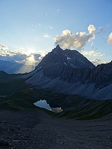
View of the Lai Tigiel and Piz Mitgel .

View to the Tinzenhorn .

View to Piz Ela . Lai Grond at the very back , Lai Mort in the middle . To the left of the front lakes is the Pass d'Ela , behind the Lai Grond is the Fuorcla da Tschitta .

View to (from left to right) Piz Val Lunga , Piz Salteras , Piz da Peder Bucs and Piz Bleis Marscha .


literature
- Manfred Hunziker: Club guide, Bündner Alps . From the Septimer to the Flüela. 3. Edition. Vi. Verlag des SAC, 2000, ISBN 3-85902-187-7 , p. 221 .
- National map of Switzerland, sheet 1236 Savognin, 1: 25000, Federal Office of Topography, 2009 edition.
Web links
Individual evidence
- ↑ Andrea Schorta: How the mountain got its name . Small Rhaetian name book with two and a half thousand geographical names of Graubünden. Terra Grischuna Verlag, Chur and Bottmingen / Basel 1988, ISBN 3-7298-1047-2 , p. 93 .
- ↑ Andrea Schorta: How the mountain got its name . Small Rhaetian name book with two and a half thousand geographical names of Graubünden. Terra Grischuna Verlag, Chur and Bottmingen / Basel 1988, ISBN 3-7298-1047-2 , p. 96 .
- ↑ Bike & hiking bus timetable on the Savognin Bivio Albula holiday region website, accessed on April 8, 2018