
Pass Digls Orgels
| Pass Digls Orgels | |||
|---|---|---|---|
 Pass digls Orgels, recorded by Lai Tigiel |
|||
| Compass direction | west | east | |
| Pass height | 2699 m above sea level M. | ||
| Canton | Graubünden , Switzerland | ||
| Watershed | Ragn da Tigiel ( Ragn d'Err / Gelgia / Albula / Hinterrhein / Rhine ) | Selabach ( Albula / Hinterrhein / Rhine ) | |
| Valley locations | Tinizong | Filisur | |
| expansion | trail | ||
| Mountains | Albula Alps | ||
| profile | |||
| Ø pitch | 21% (1467 m / 6.98 km) | 17.8% (1700 m / 9.56 km) | |
| map | |||
|
|||
| Coordinates | 771 179 / 164 251 | ||

The digls Orgels pass ( Rhaeto-Romanic organ ' organ ' ) is an Alpine pass in the Swiss canton of Graubünden . With a peak height of 2699 m above sea level. M. it connects the Oberhalbstein with the Albula valley via the Val d'Err and the Val Spadlatscha . The pass is located between the Tinzenhorn in the north and the Cotschen in the south. The pass got its name from the peculiarly pointed, narrow, partly perforated dolomite gendarmes, which are reminiscent of organ pipes .
In the summer months, the pass is often climbed at the transition from the Ela hut to Tinizong or Savognin .
Location and surroundings
.jpg)
The digls Orgels pass is part of the Bergüner Stöcken , a subgroup of the Albula Alps . The municipal boundary between Surses and Bergün Filisur runs over the pass . The digls Orgels pass is bordered in the west by the Alp Tigiel in the Val d'Err , a side valley of the Oberhalbstein , and in the east by the Val Spadlatscha , a side valley of the Albula valley. It connects the Tinzenhorn ( 3173 m ) in the north with the Cotschen ( 2821 m ) in the south.
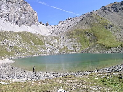
West of the digls Orgels pass is the often visited mountain lake Lai Tigiel ( 2462 m ).
The pass lies in the middle of Parc Ela , a 600 square kilometer nature park opened in 2006 .
Valley locations are Tinizong , Savognin and Filisur. Frequent starting points are the Ela hut ( 2252 m ) in the Val Spadlatscha and the Plang la Curvanera car park ( 1844 m ), which can be reached via a narrow alpine road .
Routes to the pass

The pass is not only used when crossing from west to east. A hiking trail also leads south over the Cotschen ( 2821 m ) to the Pass d'Ela ( 2724 m ). A frequent starting point is the Plang la Curvanera car park ( 1893 m ), to which a small road leads from Savognin via Tussagn. The alpine road from Tinizong into the Val d'Err to Penza is closed to general motor vehicle traffic. A hiking bus runs from Savognin to Plang la Curvanera on Wednesdays and to Pensa on Tuesdays and Fridays.
From the Ela hut
- Starting point: Filisur ( 999 m ), Bergün ( 1373 m ) or Ela hut ( 2252 m )
- Difficulty: B than trail white-red-white marks
- Time required: 5 hours from Filisur, 4½ hours from Bergün or 1½ hours from the Ela hut
Through the Tigiel Valley
- Starting point: Tinizong ( 1232 m )
- Via: Tgant Pensa, Lai Tigiel ( 2462 m )
- Difficulty: B than trail white-red-white marks
- Time required: 4 hours (3 hours from Pensa)
Across the terraces of Tigiel
- Starting point: Savognin ( 1207 m ) or Plang la Curvanera car park ( 1844 m )
- Via: Plang Begls, past Tgant Son Martegn and Lai Tigiel ( 2462 m )
- Difficulty: B than trail white-red-white marks
- Time required: 4½ hours from Savognin, 3 hours from Plang la Curvanera
From the Pass d'Ela
- Starting point: Pass d'Ela ( 2724 m )
- Via: Cotschen ( 2821 m )
- Difficulty: EB , as trail white-red-white marks
- Time required: ½ hours
gallery
The digls Orgels pass as seen from Lai Tigiel .

Piz Mitgel (left) and Tinzenhorn (right). To the right of it the digls Orgels pass.

Close-up of the “organ pipes” of the Pass digls organ.

The “organ pipes” of the Pass digls Orgels seen from the Tinzenhorn .


literature
- Manfred Hunziker: Club guide, Bündner Alps. From the Septimer to the Flüela . 3. Edition. tape VI . Verlag des SAC, 2000, ISBN 3-85902-187-7 , p. 219-220 .
- National map of Switzerland, sheet 1236 Savognin, 1: 25,000, Federal Office of Topography, 2009 edition.
Web links
Individual evidence
- ↑ Andrea Schorta: How the mountain got its name. Small Rhaetian name book with two and a half thousand geographical names of Graubünden . Terra Grischuna Verlag, Chur and Bottmingen / Basel 1988, ISBN 3-7298-1047-2 , p. 110 .
- ↑ Bike & hiking bus timetable on the Savognin Bivio Albula holiday region website, accessed on April 8, 2018