
Piz Bleis Marscha
| Piz Bleis Marscha | ||
|---|---|---|
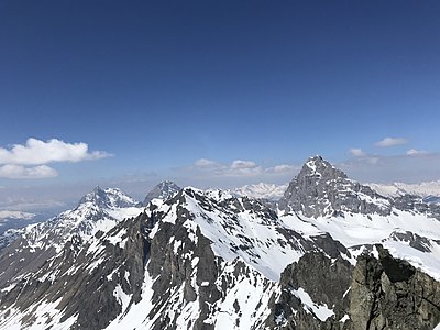
 Bleis Marscha, Piz da Peder Bucs and Piz da l'Antgierna da Salteras (from left) |
||
| height | 3127 m above sea level M. | |
| location | Canton of Graubünden , Switzerland | |
| Mountains | Albula Alps | |
| Dominance | 2.24 km → Piz Laviner | |
| Notch height | 258 m ↓ Fuorcla Mulix | |
| Coordinates | 774 858 / 160 187 | |
|
||
 Summit of Piz Bleis Marscha |
||

The Piz Bleis Marscha ( Rhaeto-Romanic in the idiom Surmiran bleis for 'steep grass slope, grass-covered steep slope' and marscha feminine to Latin marcidus for 'lazy') is a mountain southwest of Bergün and southeast of Savognin in the canton of Graubünden in Switzerland with an altitude of 3127 m above sea level M.
Location and surroundings

The Piz Bleis Marscha is the namesake and highest peak of the Bleis Marscha group, a subgroup of the Albula Alps . The municipal boundary between Surses and Bergün Filisur runs above the summit . The Piz Bleis Marscha is bordered in the west by the Val d'Err , a side valley of the Oberhalbstein , in the north-east by the Val Tschitta and in the south-east by the Val Mulix , both side valleys of the Albula valley.
Its neighboring peaks include the Piz da Peder Bucs ( 3001 m ), the Piz da l'Antgierna da Salteras ( 2981 m ), the Piz Salteras ( 3110 m ) and the Piz Ela ( 3339 m ) in the north, and the Corn da in the northwest Tinizong ( 3,173 m ) and Piz Mitgel ( 3,157 m ), in the south the Piz Laviner ( 3,136 m ) and in the southwest of the Piz Jenatsch ( 3,249 m ), the Piz d'Err ( 3,377 m ) and the Piz Calderas ( 3,397 m ).
The most distant visible point is the Matterhorn ( 4478 m ) in the Valais Alps . It is 172 km from Piz Bleis Marscha.
Valley locations are Preda and Tinizong , a frequent starting point is Naz .
Routes to the summit
The federal hunting ban area Piz Ela must be respected. Snow sports outside of the marked routes are prohibited, dogs must be kept on a leash. In addition, the operation of drones and free camping and camping is prohibited.
Summer routes
Over the northwest ridge
- Starting point: Naz ( 1746 m ) or Alp d'Err ( 2178 m )
- Via: P. 2891, Piz da l'Antgierna da Salteras ( 2981 m ) and Piz da Peder Bucs ( 3001 m )
- Difficulty: WS
- Time required: 8 hours
Over the east ridge
Through the south wall
Over the west ridge
- Starting point: Tinizong ( 1232 m )
- Via: Alp d'Err ( 2178 m ), P. 2801
- Difficulty: L
- Time required: 7½ from Tinizong, 4 hours from Alp d'Err
Through the northwest wall
- Starting point: Tinizong ( 1232 m )
- Via: Alp d'Err ( 2178 m )
- Difficulty: L
- Time required: 7½ from Tinizong, 4 hours from Alp d'Err
- Note: Comfortable in good snow conditions, very tedious when snowing out
Winter routes
From Naz
- Starting point: Naz ( 1746 m )
- Via: Val Mulix
- Exposures: E, N, S
- Difficulty: ZS +
- Time required: 4½ hours
North descent into Val Tschitta to Naz
Nice descent variant that requires safe snow and visibility.
Departure to Northwest Couloir to Tinizong
Impressive steep descent into the Val d'Err, only in safe conditions (summit couloir 40–45 degrees at 350 meters above sea level).
- End: Tinizong ( 1232 m )
- Via: From the west shoulder directly through the northwest couloir into the basin in the west of Piz da Peder Bucs
- Exposures: NW, E
- Difficulty: S
- Alternative: via Fuorcla Mulix
panorama

gallery
View to the north to the Bergüner sticks .
View from Oberhalbstein from Piz Ela to Piz d'Err , in between the Bleis Marscha group with Piz Val Lunga , Piz Salteras , Piz da l'Antgierna da Salteras , Piz da Peder Bucs and Piz Bleis Marscha (from left).
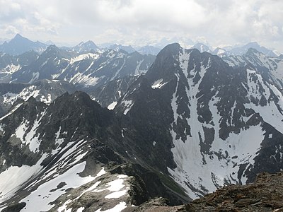
Piz Bleis Marscha from the north, taken from Piz Salteras .


literature
- Eugen Wenzel, Paul Gross: club guide, Bündner Alps . Albula. 2nd Edition. tape VI . Verlag des SAC, 1980, ISBN 3-85902-012-9 , p. 112-114 .
- Vital Eggenberger: Ski tours Graubünden South . Verlag des SAC, 2010, ISBN 978-3-85902-301-7 , pp. 122-123 .
- National map of Switzerland, sheet 1236 Savognin, 1: 25,000, Federal Office of Topography, 2015 edition.
Web links
- Calculated 360 ° panorama from Piz Bleis Marscha
- Tour reports on www.hikr.org
Individual evidence
- ↑ Andrea Schorta: How the mountain got its name . Small Rhaetian name book with two and a half thousand geographical names of Graubünden. Terra Grischuna Verlag, Chur and Bottmingen / Basel 1988, ISBN 3-7298-1047-2 , p. 68 .
- ↑ Andrea Schorta: How the mountain got its name . Small Rhaetian name book with two and a half thousand geographical names of Graubünden. Terra Grischuna Verlag, Chur and Bottmingen / Basel 1988, ISBN 3-7298-1047-2 , p. 102 .
- ↑ Calculated 360 ° panorama ( U. Deuschle ; information ) from Piz Bleis Marscha
- ↑ Federal Hunting Banned Areas Website of the Federal Office for the Environment FOEN. Retrieved April 11, 2020.