Preda
| Preda | |
|---|---|
| State : |
|
| Canton : |
|
| Region : | Albula |
| Political community : | Bergün Filisur |
| Postal code : | 7482 |
| Coordinates : | 779 203 / 162 344 |
| Height : | 1789 m above sea level M. |
| Residents: | 3 |
| Website: | www.preda.ch |
|
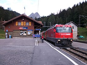
Preda station with Regioexpress |
|
| map | |
Preda is a small town in the Swiss municipality of Bergün Filisur (until the end of 2017 Bergün / Bravuogn ) in the upper Albula valley in the Albula Alps . It is located on the road over the Albula Pass at 1789 meters above sea level and at the north portal of the Albula tunnel of the Rhaetian Railway . In Preda, the ramp of the Albula Railway , which overcomes a height difference of 416 m from Bergün to Preda and leads from Chur or Davos to St. Moritz , ends at the route of the Glacier Express .
In addition to the train station, an important intersection with a long double-track line and a shunting area with sidings, there is the Kulm Hotel, the Sonnenhof Gasthaus & Gruppenhaus, a farm and several chalets in Preda. Since the construction of the railway line, there has also been a hydroelectric power station that is supplied with water through a tunnel from Lake Palpuogna . The valley floor is used for agriculture, above there are extensive forest areas. There are several Alps beyond the tree line. The Maiensässsiedlung Naz is located in the immediate vicinity of Preda .
The pass is closed in winter above Preda. Below Preda to Bergün, the road serves as a natural toboggan run in winter (longest natural toboggan run in Europe). The tobogganers are transported to Preda with regular trains and additional toboggan trains. In winter there is a snowshoe trail at Preda.
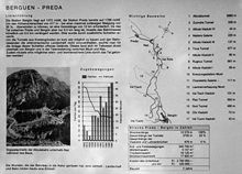
Numerous hiking trails are available in summer. Preda is the starting point of a 7 km long educational railway trail to Bergün, which mostly follows the railway line down the valley, and a stage stop on the Via Albula / Bernina hiking trail .
East of Preda, on the 2312 meter high Albula Pass, lies the watershed between the Rhine ( North Sea ) and Inn ( Black Sea ).

Construction of the Albula tunnel (2nd tube) began in summer 2014.


