Palpuogna lake
|
Lai da Palpuogna Lake Palpuogna |
||
|---|---|---|

|
||
| Geographical location |
Albula Alps GR CH |
|
| Tributaries | Albula | |
| Drain | Albula | |
| Data | ||
| Coordinates | 779 865 / 161 592 | |
|
|
||
| Altitude above sea level | 1918 m above sea level M. | |
| length | 500 m | |
| width | 100 m | |
| Maximum depth | 25 m | |
|
particularities |
Reservoir |
|

|
||
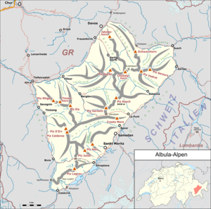
The Palpuognasee ( Rhaeto-Romanic Lai da Palpuogna ) is located in the Albula Alps at 1918 m above sea level. M. above Preda in the Swiss canton of Graubünden .
Location and surroundings
The meaning of the name Palpuogna is not known, but is considered the oldest known name in connection with the history of Bergün and is mentioned as early as 1139 in connection with the delimitation of the episcopal area.
The lake is about eight kilometers above Bergün on a prominent valley step at the foot of Piz Palpuogna and can be reached via the Albula pass road. The right side of the valley is marked by Piz Üertsch and Piz Muot . It's about five kilometers from the lake to the Albula Pass .
The water of the lake with its clear blue-green tones offers a play of colors , especially in autumn when the larches surrounding it are yellow.
Special
The water of the originally natural lake was used to generate electricity as early as 1898. For this purpose, the level was increased slightly (approx. 30 cm) by a small wall. Thus, the Palpuogna lake has been a reservoir since then. The water is led through a pressure pipe to Preda, where electricity is generated. The plant was built back then to generate electricity for the construction of the Albula tunnel and is now owned by the Bergün power station. During the construction period from 1899 to 1903, water was also taken from the lake in order to operate the Brandtschen rock drilling machines in the northern section. These drilling machines had a pressurized water drive.
The bottom of the lake has many craters from which natural gases escape. In places the lake has a double bottom, that is, an underground sea chamber.
In June 2007, the lake was voted “Switzerland's most beautiful spot” in a survey by SF 1 .
literature
- Reto Barblan: Bergün / Bravuogn, A journey through time through the history of the village . Self-published (see Bergün Tourismus, Service), 1995.
- Association for Bündner Kulturforschung (VBK) (ed.): Festschrift UNESCO World Heritage Rhaetian Railway in the Albula / Bernina landscape . Grisons Monatsblatt (reprint), 2008, ISSN 1011 to 6,885 .
Web links
- Lai da Palpuogna on schweizersee.ch
- Bergün website
Individual evidence
- ↑ SRF Player ( Memento of the original from July 25, 2014 in the Internet Archive ) Info: The archive link was inserted automatically and has not yet been checked. Please check the original and archive link according to the instructions and then remove this notice.
