Gmina Pniewy
| Gmina Pniewy | ||
|---|---|---|

|
|
|
| Basic data | ||
| State : | Poland | |
| Voivodeship : | Greater Poland | |
| Powiat : | Szamotulski | |
| Geographic location : | 52 ° 30 ' N , 16 ° 15' E | |
| Residents : | s. Gmina | |
| Postal code : | 62-045 | |
| Telephone code : | (+48) 61 | |
| License plate : | PSZ | |
| Economy and Transport | ||
| Street : | DK 24 Pniewy - Skwierzyna | |
| DK 92 Lwówek - Poznan | ||
| Next international airport : | Poznan-Ławica | |
| Gmina | ||
| Gminatype: | Urban-and-rural parish | |
| Gmina structure: | 21 school authorities | |
| Surface: | 158.57 km² | |
| Residents: | 12,608 (Jun. 30, 2019) |
|
| Population density : | 80 inhabitants / km² | |
| Community number ( GUS ): | 3024063 | |
| administration | ||
| Mayor : | Jarosław Przewoźny | |
| Address: | ul.Dworcowa 37 62-045 Pniewy |
|
| Website : | www.pniewy.wlkp.pl | |
The Gmina Pniewy is an urban-and-rural municipality in the powiat Szamotulski of the Greater Poland Voivodeship in Poland . Its seat is the city of the same name ( German Pinne ) with about 8000 inhabitants.
geography
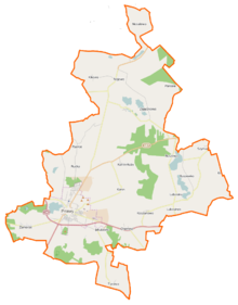
The municipality is located in the west of the voivodeship, about 40 kilometers west of Poznan and 12 kilometers southwest of the district town of Szamotuły (Samter) . Neighboring municipalities are the municipalities of Wronki in the north, Ostroróg and Szamotuły in the east, Duszniki in the southeast, Lwówek in the south and Kwilcz and Chrzypsko Wielkie in the west.
The municipality is rich in smaller lakes, including Jezioro Pniewskie in the south and Jezioro Buszewskie in the northeast. The community has an area of 158.6 km², 74 percent of which is used for agriculture and 16 percent for forestry.
history
The current municipal area came from 1975 to 1998 from the Poznan large-scale Voivodeship to the small-scale Poznan Voivodeship . During this time the powiat was dissolved. The rural community of Pniewy was repeatedly converted into Gromadas after 1954 and newly created on January 1, 1973.
The town and country municipality of Pniewy were merged in 1990/1991 to form the town and country municipality. This has belonged to the Greater Poland Voivodeship since 1999 and again to the Powiat Szamotulski.
The local elections , held on May 27, 1990, were the first completely free elections in over 50 years. The turnout was just 42 percent.
City and community partnerships
The community entered into a number of community partnerships between 1996 and 2015 :
- Alphen-Chaam , Netherlands
- Halluin , France - since 1998
- Kočevje , Slovenia
- Kościerzyna , Poland - since 2015
- Lübbenau / Spreewald , Germany - since 1996
- North Tyneside , UK
- Oer-Erkenschwick , Germany - since 2001
- Radków , Poland - since 2000
structure
The town itself and a number of villages and towns, which make up 21 school authorities, belong to the town-and-country municipality (gmina miejsko-wiejska) Pniewy with 12,608 inhabitants (as of June 30, 2019).
Schulzenämter
The community had 12,249 inhabitants on December 31, 2017, of whom 7780 lived in the city and 4469 in the places of the 21 school offices.
Population as of December 31, 2017.
- Chełmno - 422
- Dębina, Buszewko, Szymanowo - 383
- Dęborzyce, Buszewo - 348
- Jakubowo - 88
- Carmine - 95
- Kikowo - 138
- Konin - 216
- Koninek, Konin Huby, Psarki - 139
- Koszanowo - 178
- Lubocześnica - 224
- Lubosina, Lubosinek, Przystanki - 373
- Nojewo, Podborowo - 308
- Nosalewo - 68
- Orliczko - 146
- Podpniewki - 142
- Psarce - 45
- Psarskie - 273
- Rudka - 111
- Turowo - 287
- Zajączkowo - 265
- Zamorze, Dąbrowa, Berdychowo - 220
Villages of the municipality
The official German names are listed.
| Polish name | German name (1815-1918) |
German name (1939-1945) |
|---|---|---|
| Buszewko | Buschewo estate 1907–1918 Marisfeld estate |
Marisfeld |
| Buszewo | Bushevo | Marisfelde |
| Chełmno | Chelmno | Hünenort |
| Debina | Dembina 1911-1918 Dembin |
Dembin |
| Dęborzyce | Zalewo | Haidchenkrug |
| Jakubowo | Jakubowo | ? |
| Carmine | Vorwerk Karmin | Carmen |
| Kikowo | Gut Nojewo-Kikowo 1900–1918 Richthausen |
Richthausen |
| Konin | Konin | Kunfelde |
| Koninek | Koninko | Klein Kunfelde |
| Koszanowo | Koschanowo | Ruhland |
| Lubocześnica | Luboszesnica 1911–1918 Luboschesnitza |
Feldheim |
| Lubosina | Good Lubosin |
1939–1943 Gut Karlshöhe 1943–1945 Karlssee |
| Lubosinek | Lubosin degradation |
1939–1943 Karlshöhe dismantling 1943–1945 Karlssee dismantling |
| Nojewo | Nojewo 1898-1918 Neuthal |
Neutral |
| Nosalewo | Nossalewo | Hawthorn |
| Orliczko | Orlitschko | Goat mountain |
| Podpniewki | Podpniewki | Gallows Mountain |
| Przystanki | Przystanki 1906–1918 Karlshöhe |
Karlshöhe |
| Psarce | Great Psarskie Hauland | ? |
| Psarki | Klein Psarskie Hauland | ? |
| Psarskie | Psarskie | Hauland |
| Rudka | Rudki Hauland | ? |
| Turowo | Turowo | Westfalenhof |
| Zajączkowo | Well Zajontschkowo | Good Zealand |
| Zamorze | Zamorze 1906–1918 Georgsburg |
Georgsburg |
- Smaller towns
Other localities in the municipality are the Szymanowo colony (Vorwerk Szymanowo) as well as the hamlets and settlements Berdychowo, Bielawy, Bukowina, Dąbrowa (Dombrow) , Jakubowo (osada), Konin Huby, Podborowo (Vorwerk Podborowo) , Śródka and Stefanowo.
traffic
The national road DK24 (droga krajowa 24) leads from Pniewy to the west and ends at Gorzów Wielkopolski (Landsberg an der Warthe) . The national road DK92 leads from Poznan in the east via Pniewy first to the south, where the A2 motorway ( E 30 ) is reached after 20 kilometers . The DK92 then runs west via Świebodzin (Schwiebus) to Rzepin (Reppen) . The southern bypass was started in 1996. The voivodship road DW187 runs through the main town in a north-westerly direction to Szamotuły (Samter) . From it the DW116 branches off , which leads through the north of the municipality towards Wronki (Wronke) .
The nearest international airport is Poznan-Ławica , about 40 kilometers away.
The Pniewy Szamotulskie station in the main town of the municipality and a stop in Lubosina existed on the railway line from Poznan to Gorzów Wielkopolski. Passenger traffic on this section ceased in 1999. The railway line from Szamotuły to Międzychód (pear tree) ran through the north of the municipality. There were stops in Nojewo and Kikowo. Passenger traffic was discontinued in 1995 and freight traffic in the following year.
Personalities
The following were appointed honorary citizens of the community:
- 1937: Maria Ursula Ledóchowska (1865–1939), saint and founder of the Gray Ursulines
- 2012: Wojciech Raczkowski (1932–2013), priest and honorary canon of the cathedral chapter in Poznan.
A street is named after the doctor and participant in the battle for Monte Cassino Włodzimierz Felicki (1891–1957).
Web links
- City and municipality website (Polish)
Individual evidence
- ↑ population. Size and Structure by Territorial Division. As of June 30, 2019. Główny Urząd Statystyczny (GUS) (PDF files; 0.99 MiB), accessed December 24, 2019 .
- ↑ a b pniewy.wlkp.pl: Historia Pniew . (Polish, accessed April 10, 2020)
- ↑ pniewy.wlkp.pl: Gminy partnerskie . (Polish, accessed April 10, 2020)
- ↑ pniewy.wlkp.pl: Sołectwa . (Polish, accessed April 10, 2020)
- ↑ pniewy.wlkp.pl: Pniewy w liczbach . (Polish, accessed April 10, 2020)
- ↑ pniewy.wlkp.pl: Honorowi obywatele . (Polish, accessed April 10, 2020)

