Radków
| Radków | ||
|---|---|---|

|
|
|
| Basic data | ||
| State : | Poland | |
| Voivodeship : | Lower Silesia | |
| Powiat : | Kłodzko | |
| Area : | 15.07 km² | |
| Geographic location : | 50 ° 30 ' N , 16 ° 24' E | |
| Height : | 388 m npm | |
| Residents : | 2406 (June 30, 2019) |
|
| Postal code : | 57-420 | |
| Telephone code : | (+48) 74 | |
| License plate : | DKL | |
| Economy and Transport | ||
| Street : | Nowa Ruda - Kudowa-Zdrój | |
| Next international airport : | Wroclaw | |
| Gmina | ||
| Gminatype: | Urban and rural municipality | |
| Gmina structure: | 13 towns | |
| Surface: | 139.00 km² | |
| Residents: | 9048 (June 30, 2019) |
|
| Population density : | 65 inhabitants / km² | |
| Community number ( GUS ): | 0208123 | |
| Administration (as of 2007) | ||
| Mayor : | Jan Bednarczyk | |
| Address: | Rynek 1 57-420 Radków |
|
| Website : | www.radkowklodzki.pl | |
Radków ( German Wünschelburg ; Czech Hrádek , also Radkov ; formerly also Radek or Vinšlburk ) is a town and seat of the town and country municipality of the same name in the powiat Kłodzki ( Glatz district ) in the Lower Silesian Voivodeship in Poland.
Geographical location
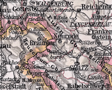
The city is located in the southwest of the Glatzer Kessel on the Pośna (German Posna , also Rathener Wasser ), which rises in the Heuscheuergebirge and flows into the stones at Ścinawka Średnia ( Mittelsteine ) . Droga wojewódzka 387 runs through the village .
Neighboring towns are Ratno Górne ( Oberrathen ), Ratno Dolne ( Niederrathen ) in the east, Wambierzyce ( Albendorf ) in the southeast, Karłówek ( Klein Karlsberg ) and Karłów ( Karlsberg ) in the southwest, Pasterka ( Passendorf ) in the west, Gajów ( Reichenforst ) and Tłumaczów ( Tuntschendorf ) in the northeast. Across the border to the Czech Republic, which runs in the northwest, are in the West Studena Voda ( cold Waser ), in the northwest Božanov ( Barzdorf ) and Martinkovice ( Märzdorf ) and in the north Otovice ( Ottendorf ).
history
Wünschelburg has belonged to the Glatzer Land since ancient times . Its political and ecclesiastical affiliation is therefore largely identical to the history of the County of Glatz , within which it formed the "Wünschelburg District".
Wünschelburg was probably founded before 1290, as the Bartholomäuskirche in the suburb is mentioned for this year . The place is documented for the year 1328. 1341 it is called civitas . After the city was fortified with a wall and moat, the Bohemian King Wenceslaus IV granted it the privilege of a Bohemian royal city in 1418 .
During the Hussite Wars , Wünschelburg was looted and burned down several times. Further destruction and damage was caused in 1469 by the troops of the Hungarian King Matthias Corvinus . After the reconstruction, an economic boom followed, in which the cloth makers and linen weavers played a major role. In 1485 Zbinko von Buchau ( Zbyněk z Buchova ) was the heir to Wünschelburg and Rathen, who was then court marshal of Count Heinrich the Elder. Ä. was. In the first half of the 16th century, Wünschelburger cloth was delivered to Italy.
Around 1550 the Reformation also took hold in Wünschelburg . 1571–1580 the evangelical citizens built a parish church. In the course of the Counter Reformation , the church was handed over to the Catholics in the 1620s. The older Bartholomäuskirche in the suburbs served as a burial church from this time on. It was demolished in 1738.
1601 acquired the city Wuenschelburg of Emperor Rudolf II. The Kammergut Passendorf with Nauseney and the colony Brunn Kress . These places had previously belonged to the Hummel rule , which was dissolved at the end of the 16th century. At the same time, all three places were incorporated into the parish of Wünschelburg.
During the Thirty Years' War , the population of Wünschelburg had to endure billeting and looting. In 1680 500 inhabitants are said to have died of the plague. In 1738 almost the whole city burned down. The Silesian Wars brought further harassment for the population . The city was slow to recover from this devastation.
After the First Silesian War in 1742 and finally after the Peace of Hubertusburg in 1763, Wünschelburg fell to Prussia together with the County of Glatz . After the reorganization of Prussia, it belonged to the province of Silesia from 1815 , which was divided into districts. The district of Glatz was responsible from 1816–1853, and the district of Neurode from 1854–1932 . After its dissolution in 1933, Wünschelburg was again part of the Glatz district until 1945.
The creation of a footpath to Karlsberg and from there to the rock town of the Heuscheuer in the 18th century favored the later development of tourism. One of the first users of this path after King Friedrich Wilhelm II of Prussia was Johann Wolfgang von Goethe , who lived in Wünschelburg from August 27th to 29th, 1790 and rose to the barn on August 28th on his 41st birthday.
The "Wünschelburger Korn", which was distilled from 1756 on, gained economic importance. On the other hand, cloth and linen weaving declined around 1830, after which wool weaving gained in importance. The tourist boom was promoted with the road from Wünschelburg via Karlsberg to Bad Kudowa , built between 1867 and 1870 . From 1893 the sandstone industry developed. Wünschelburg sandstone was delivered from the quarries near Wünschelburg for the Reichstag building and other Berlin buildings. The railway connection , which Wünschelburg reached from Mittelsteine in 1903, had a positive effect on economic and tourist development . In 1914 the Mittelsteine railway power station was built, which supplied the electrified railway lines in Silesia with traction current .
In 1945 Wünschelburg belonged to the district of Glatz in the administrative district of Breslau in the Prussian province of Silesia of the German Empire .
As a result of the Second World War , Wünschelburg, like almost all of Silesia, was placed under Polish administration by the Soviet occupying power in 1945 and renamed Radków . The German population was expelled from Wünschelburg by the local Polish administrative authority in March, October and November 1946 . About 50 people who were considered indispensable for the sandstone industry were held back. They were also expelled in the following years. Only the old skilled worker Schölpert and his daughter, who ran the household for him, were held back. Some of the newly settled residents came from the areas east of the Curzon Line that fell to the Soviet Union . In the 1970s, a reservoir and holiday homes were built to the west of the village.
From 1975 to 1998 Radków was part of the Wałbrzych Voivodeship ( Waldenburg ).
Population development
| year | Residents | Remarks |
|---|---|---|
| 1890 | 2101 | including 693 Evangelicals and 57 Jews |
| 1933 | 2542 | |
| 1939 | 2558 |
Attractions
- The parish church of St. Dorothea ( Kościół Św. Doroty ) was built between 1570 and 1580 and after the fire of 1738 it was rebuilt and redesigned in Baroque style. The murals were created by the Braunau painter J. Hausdorf.
- The branch church of St. Andrew ( Kościół Św. Andrzeja ) was built in 1905–1906 in neo-Baroque and Art Nouveau forms as a Protestant church. Since 1945 it has served as a Catholic church.
- The town hall was built around 1550 and expanded in 1609–1628 and 1750. Renovations were carried out in 1852 and 1882–1885.
- The Marian column on the ring was built after the plague epidemic of 1680.
- There are still some old baroque and renaissance houses on the ring . Several houses in the ring development were abandoned to decay after 1945.
local community
The following localities belong to the urban and rural municipality of Radków:
- Gajów ( Reichenforst )
- Karłów ( Karlsberg )
- Ostra Góra ( Nauseney )
- Pasterka ( Passendorf )
- Radków ( Wünschelburg )
- Raszków ( Seifersdorf )
- Ratno Dolne ( Niederrathen )
- Ratno Górne ( Oberrathen )
- Suszyna ( Dürrkunzendorf )
- Ścinawka Dolna ( Niedersteine )
- Ścinawka Górna ( Obersteine )
- Ścinawka Średnia ( central stones )
- Tłumaczów ( Tuntschendorf )
- Wambierzyce ( Albendorf )
Town twinning
sons and daughters of the town
- Paul Nößler (1929–2018), German miner, representative of expellees and local politician in North Rhine-Westphalia
- Wolfgang Stumph (* 1946), German actor and cabaret artist
literature
- Dehio Handbook of Art Monuments in Poland. Silesia. Deutscher Kunstverlag, Munich et al. 2005, ISBN 3-422-03109-X , pp. 793–794.
- Peter Güttler: The Glatzer Land. A travel guide to the landscape, art and culture of the Kłodzko Mountains / Ziemia Kłodzka in Silesia. Aktion West-Ost eV, Düsseldorf 1995, ISBN 3-928508-03-2 , pp. 119-120.
- Hugo Weczerka (Hrsg.): Handbook of the historical places . Volume: Silesia (= Kröner's pocket edition . Volume 316). Kröner, Stuttgart 1977, ISBN 3-520-31601-3 , pp. 573-574.
- Johann Wolfgang von Goethe: From the notebook from the Silesian journey. In: Goethe Works, Weimar Edition III. Section Volume 2: July – September 1790, 1887
- Adalbert Hoffmann: The Goethe Day of the Schneekoppe and the Heuscheuer for a new source. In: The hiker in the Giant Mountains. 42nd year No. 47 Johann Friedrich Zöllner : Letters about Silesia, Cracow, Wieliczka and the County of Glatz. Friedrich Maurer publishing house. Berlin, 1795, p. 433 Victor Kaluza : The Great Heuscheuer. Ascent in Goethe's footsteps . Novella about Goethe's stay on his 41st birthday in 1790 on the hay barn near Radków. In: Silesia . Vol. 31. Nuremberg 1986. H. 3, pp. 159-168.
Web links
- Website about Radków ( Memento from November 26, 2013 in the Internet Archive ) (German)
- Historical and current recordings as well as geographical location
- Historical overall view, among others
Individual evidence
- ↑ a b population. Size and Structure by Territorial Division. As of June 30, 2019. Główny Urząd Statystyczny (GUS) (PDF files; 0.99 MiB), accessed December 24, 2019 .
- ↑ Marek Šebela, Jiři Fišer: České Názvy hraničních Vrchů, Sídel a vodních toků v Kladsku . In: Kladský sborník 5, 2003, p. 370.
- ^ Jan Karel Hraše: Dějiny Náchoda 1620–1740 . Náchod 1994, ISBN 80-900041-8-0 , p. 442.
- ^ František Musil: Kladsko v době vlády Lucemburků . In: 550 let Hrabství Kladského. 1459-2009. = 550 lat hrabstwa Kłodzkiego. 1459–2009 (= Kladský sborník. Supplementum. Vol. 6). Muzeum Podkrkonoší, Trutnov 2009, ISBN 978-80-903741-3-3 , p. 50.
- ^ Karl-Helmut Klose: Burgen und Schlösser der Grafschaft Glatz , Marx Verlag 1997, ISBN 3-87854-128-7 , pp. 122-130.
- ↑ Marin Šandera: Jindřich starší z Minstrberka. Vyšehrad 2016, ISBN 978-80-7429-687-1 , pp. 141, 233, 235 and 241.
- ^ Aloys Bach : Documented Church History of the Graffschaft Glaz [sic], Breslau 1841, p. 410 online
- ^ Karl August Müller: Vaterländische Bilder, in a history and description of the old castle festivals and knight castles of Prussia . Flemming, 1837, p. 108 ( preview in Google Book search).
- ↑ Grain Distillery
- ↑ Rafał Wiernicki, Kolej Stołowogórska (Polish)
- ↑ Paul Menzel: Blown away in all winds. How the German town of Wünschelburg became the Polish Radków . Wünschelburger Edition, Anröchte, 1986.
- ^ A b c Michael Rademacher: German administrative history from the unification of the empire in 1871 to the reunification in 1990. glatz.html # ew39gltzwunsch. (Online material for the dissertation, Osnabrück 2006).


