
Lewin Kłodzki
| Lewin Kłodzki | |||
|---|---|---|---|

|
|
||
| Basic data | |||
| State : | Poland | ||
| Voivodeship : | Lower Silesia | ||
| Powiat : | Kłodzko | ||
| Geographic location : | 50 ° 25 ′ N , 16 ° 17 ′ E | ||
| Height : | 440 m npm | ||
| Residents : | 1200 () | ||
| Postal code : | 57-343 | ||
| Telephone code : | (+48) 74 | ||
| License plate : | DKL | ||
| Economy and Transport | |||
| Street : | Wroclaw - Prague | ||
| Rail route : | Kłodzko – Kudowa Zdrój | ||
| Next international airport : | Wroclaw Airport | ||
| Gmina | |||
| Gminatype: | Rural community | ||
| Gmina structure: | 17 localities | ||
| Surface: | 52.19 km² | ||
| Residents: | 1940 (June 30, 2019) |
||
| Population density : | 37 inhabitants / km² | ||
| Community number ( GUS ): | 0208092 | ||
| Administration (as of 2015) | |||
| Community leader : | Joanna Klimek-Szymanowicz | ||
| Address: | Nad Potokiem 4 57-343 Lewin Kłodzki |
||
| Website : | www.lewin-klodzki.pl | ||

Lewin Kłodzki [ ˈlɛvʲin ˈkwɔʦci ] (German Lewin , 1938–1945 Hummelstadt , Czech Levín , also Kladský Levín ) is a village in the powiat Kłodzki in the Lower Silesian Voivodeship in Poland. It is the seat of the Lewin Kłodzki rural community .
Geographical location
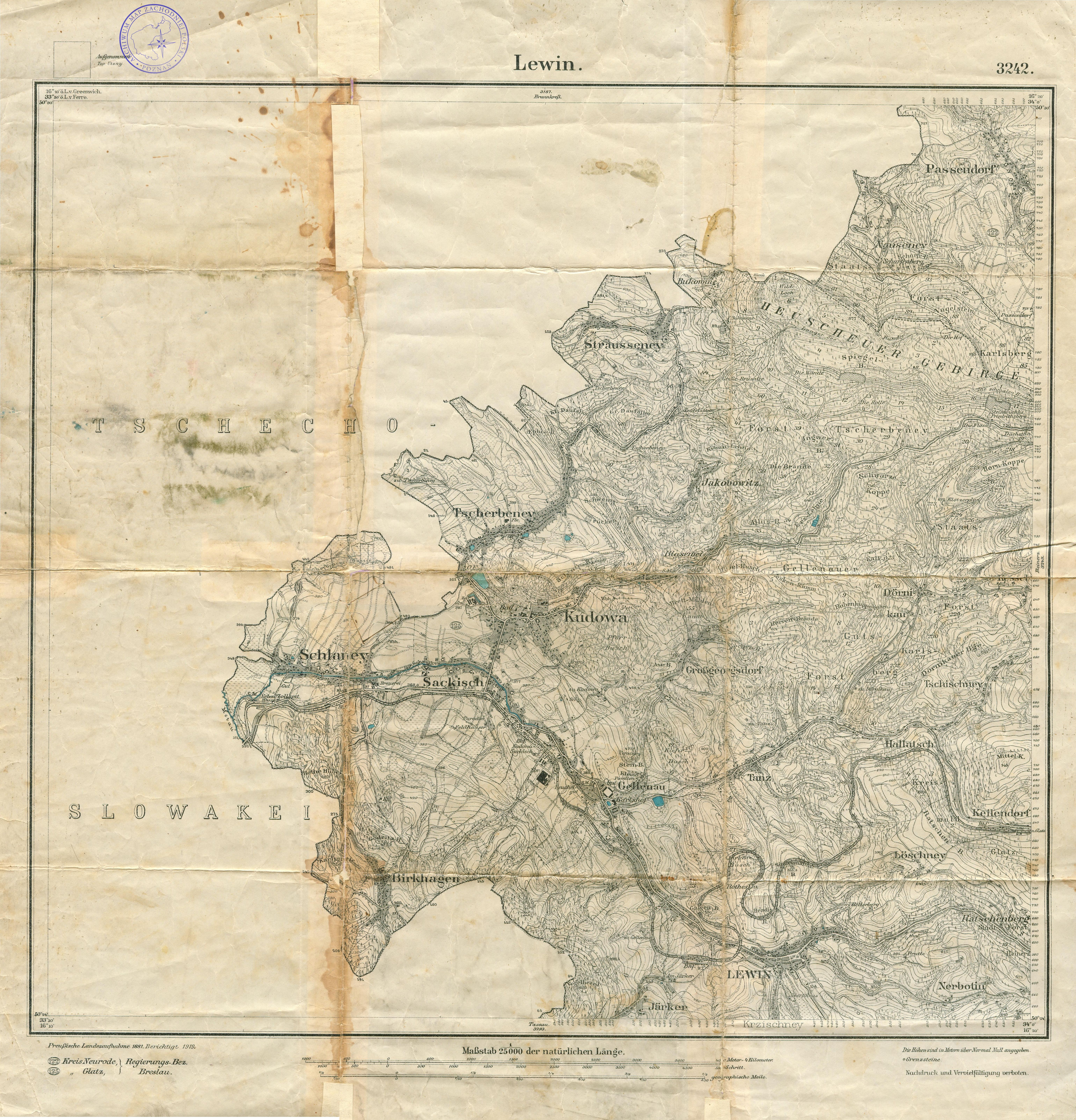
Lewin Kłodzki is located 31 kilometers west of the district town of Kłodzko ( Glatz ) on the European route 67 , which runs east of Lewin over the Hummelpass between the Heuscheuergebirge and the Habelschwerdter Mountains and further through the Glatzer Kessel . The Schnell ( Bystra ), a left tributary of the Mettau ( Metuje ), flows through the village .
Neighboring towns are Dańczów ( dance ) in the north, Duszniki-Zdrój ( Bad Reinerz ) and Witów ( German Nerbotin; 1937–1945: Markrode ) in the east, Krzyżanów ( Kreuzdorf ) in the south, Jarków ( Järker ) in the southwest and Jeleniów ( Gellenau ) in the West. The border with the Czech Republic runs three kilometers to the southwest .
history


.jpg)
Lewyn was first mentioned in writing in 1354, when the local pastor introduced a new pastor in neighboring Gießhübel . The earlier assumption, Lewin would have been 1238 exists, based on an error, which thus came about that in a document of King I. Wenceslas called Lewin ( Levi Nice ) in Laun , the contributions to the Glatzer had to do castle, both from Glatzer Local researcher Joseph Kögler and 1855 by the historian Karel Jaromír Erben was mistakenly confused with this Lewin. It originally belonged to the Nachod dominion in the old Bohemian Königgrätzer Kreis , whose eastern border it formed. Ecclesiastically it was incorporated into the Bohemian deanery Dobruška . In 1360 it was owned by the brothers Hynek / Heinrich and Ješek / Jan von Dubá auf Náchod , who later shared their possessions. Hynek kept Náchod and Ješek received Lewin with the villages that were part of the parish church of St. Michael. North of the city he built the Lewin Castle on the Hradisch ( Hradiště also Hrad Levín ), which was not identical to the Hummel Castle to the east between Lewin and Reinerz . For the year 1367 Ješek is proven as patron of the Lewin parish church St. Michael. Lewin gained importance due to its location on the important trade and military route that led from Prague via Glatz and Wartha to Wroclaw and was also referred to as the "Poland" or "Royal Route". Presumably Lewin had already in 1415 town charter . In 1428 the Hussites invaded and destroyed Lewin and the castle on the Hradisch. From the Hummel Castle to the east, they undertook campaigns in the Glatzer Land and Silesia .
In 1477 Duke Heinrich d. Ä. , to which the reigns Nachod and Hummel as well as the county Glatz belonged since 1472 , the entire parish Lewin in the rule Hummel and this in the same year in the county Glatz. After the rule Hummel was dissolved at the end of the 16th century, Lewin formed the Hummeldistrikt ("Humblischer District") within the County of Glatz. Lewin remained a Czech language area for a long time, but in contrast to the neighboring Bohemian corner , Germanization took place as early as the 17th century. The last Czech entries in the city register date from 1680.
During the Thirty Years' War Lewin was several times the marching area of the imperial troops , some of which also set up their winter quarters here and had to be fed. Billing and the payment of contributions had to be endured. In 1639 and 1649 the Swedes also plundered Lewin while marching through the County of Glatz. The residents fled to the surrounding forests.
The plague epidemic of 1680, which claimed many victims, was followed by severe devastation in 1687 due to a flood caused by a downpour. Two major city fires destroyed parts of Lewin in 1703 and 1772. The remote parish church of St. Michael survived the fires unscathed.
During the Silesian Wars , too , Lewin was the deployment area for Prussian and Austrian troops. The Prussian Colonel von Kleist stayed in the Lewin rectory in November 1744. After the First Silesian War in 1742 and finally after the Peace of Hubertusburg in 1763, Lewin fell to Prussia together with the County of Glatz . After the reorganization of Prussia, Lewin belonged to the province of Silesia from 1815 . At the beginning of the 20th century Lewin had a Catholic church, a weaving mill, a linen factory and was the seat of a local court .
The city was incorporated into the district of Glatz from 1816 to 1945. Lewin had been a municipality since 1874, and in 1934 it was officially referred to as the town of Lewin, which was renamed Hummelstadt in 1938. With the opening of the section from Bad Reinerz to Bad Kudowa in 1905, Lewin was connected to the railway network.
Towards the end of the Second World War , Hummelstadt was occupied by the Red Army in the spring of 1945 and, after the end of the war, was placed under Polish administration by the Soviet Union and almost all of Silesia . Then the place was renamed Lewin Kłodzki . At the same time the town lost its city rights . The immigration of Polish migrants began. The German population was largely expelled by the local Polish administrative authorities in 1945/46 . Some of the Polish migrants came from areas east of the Curzon Line that fell to the Soviet Union , where they belonged to the Polish minority.
From 1975 to 1998 Lewin Kłodzki belonged to the Wałbrzych Voivodeship ( Waldenburg ).
Economic development
Spoon carving has been an important source of income for the inhabitants of Lewin since the 16th century. Around 1700 this craft was replaced by linen weaving. The number of looms rose from 108 in 1724 to 132 in 1750. In 1794 there were already 262 looms. In the 19th century weaving declined and the population lived in great poverty. In 1830 the flax , yarn and canvas markets , which had taken place once a week since 1659, were closed. In 1897 an embroidery school was founded. At the beginning of the 20th century, a few factories were established that produced stockings, confectionery and glass products.
Demographics
| year | population | Remarks |
|---|---|---|
| 1787 | 886 | in 166 town houses |
| 1816 | 919 | |
| 1825 | 997 | including eleven Evangelicals |
| 1840 | 1301 | including eleven Evangelicals, 1289 Catholics |
| 1852 | 1497 | |
| 1867 | 1580 | on December 3rd |
| 1871 | 1616 | According to other data, 1616 inhabitants (on December 1), 37 of them Protestants, 1567 Catholics, twelve Jews |
| 1885 | 1,538 | |
| 1900 | 1396 | |
| 1933 | 1,090 | |
| 1939 | 1,049 |
- Number of inhabitants to date

Attractions


- The parish church of St. Michael was first mentioned in 1340, rebuilt in 1574–1576 and expanded in 1698. On the walls of the choir and nave as well as on the galleries there are figural paintings from 1698. Main altar from 1618 (renewed in 1736) with a painting of the Virgin Mary by Hieronymus Richter . The side altars (Infant Jesus and St. Anthony of Padua) were made by the sculptor H. Hartmann and the painter Roose, both from Wartha . Pulpit with evangelist figures from 1691; Organ brochure from 1735.
- The chapel of St. Johannes Nepomuk was built in 1727–1730 as a foundation by the Jauerniker miller David Walke; the main altar comes from the sculptor Karl Sebastian Flacker from Glatz . The side altars of Our Lady of Sorrows and St. Francis were brought here from the Lewin parish church in 1772.
- Town houses: Older buildings on the market rebuilt after fire in 1772 at the expense of the Prussian king by master builder Müller from Glatz.
- The town hall with facade decoration in the style of the Frederician Rococo was built in 1772–1776.
- The Marian column was erected in 1687, the figure of the Bohemian national saint Johannes Nepomuk in 1717
- To the north of the city, on the summit of the Hummelberg, are the remains of the Hummelburg .
Parish partnership
- Großbeeren , Germany
sons and daughters of the town
- Joseph Kögler (1765–1817), historian and local researcher for the County of Glatz
- Georg Hartmann (1887–1954), church music composer and local writer
- Violetta Villas (1938–2011), Polish chanson singer specializing in coloratura soprano, known as the voice of the atomic age.
Gmina
The Gmina Lewin Kłodzki covers 52 km² and has 2180 inhabitants. The localities belong to it:
- Dańczów ( dance )
- Darnków ( Dörnikau )
- Gołaczów ( Hallatsch , 1937–1945: Hallgrund )
- Jarków ( Järker )
- Jawornica ( Jauernig )
- Jeleniów ( Gellenau )
- Jerzykowice Małe ( Kleingeorgsdorf )
- Jerzykowice Wielkie ( Großgeorgsdorf )
- Kocioł ( tripe )
- Krzyżanów ( Krzyschney , 1929–1945: Kreuzdorf )
- Kulin Kłodzki ( Wedge Village )
- Leśna ( Löschney , 1937–1945: Thalheim)
- Lewin Kłodzki ( Lewin )
- Taszów ( Tassau )
- Witów ( Nerbotin , 1937–1945: Markrode )
- Zielone Ludowe ( Hummelwitz and Reinerzkrone )
- Zimne Wody ( cold water )
- Żyznów ( Tschischney )
literature
- Johann Georg Knie : Alphabetical-statistical-topographical overview of the villages, towns, cities and other places of the royal family. Preusz. Province of Silesia. 2nd Edition. Graß, Barth and Comp., Breslau 1845, pp. 854-855 .
- Friedrich Gottlob Leonhardi : Earth Description of the Prussian Monarchy , Volume 3, Part 1, Halle 1792, pp. 218-219 .
- Aloys Bach : Documented Church History of the County of Glaz. From primeval times to our days. In addition to an appendix: Historical statistical representation of all Gläzer parishes and churches with their spiritual leaders, as well as the schools in 1841. Fritz, Breslau 1841.
- Franz Albert: The history of the Hummel rule and its neighboring areas. First part: The rule of Hummel up to the year 1477. Self-published, Münster 1932, p. 39f.
- Ondřej Felcman: Proměny hranic východnich Čech . In: Ůzemí východních Čech od středověku po raný novověk . Hradec Králové 2011, ISBN 978-80-7422-106-4 , pp. 89 and 158.
- Dehio Handbook of Art Monuments in Poland. Silesia. Deutscher Kunstverlag, Munich et al. 2005, ISBN 3-422-03109-X , pp. 550–551.
- Joseph Kögler : The chronicles of the county Glatz. Revised and edited by Dieter Pohl . Volume 1: The town and parish chronicles of Lewin - Mittelwalde - Wünschelburg - Neurode - Wilhelmsthal. Pohl, Modautal 1993, ISBN 3-927830-06-2 , pp. 21-74 ( historical sources of the County of Glatz. Series A: Ortsgeschichte NF 1).
- Wilhelm Mader: Chronicle of the city Lewin . 2nd supplemented edition. Göbel, Lewin 1903.
- František Musil: K počátkům “Českeho Koutku” v Kladsku . In: Český Koutek v Kladsku. Lupus, Trutnov 2008, ISBN 978-80-903509-8-4 , pp. 15-22 ( Kladský sborník. Supplement 5).
- Hugo Weczerka (Hrsg.): Handbook of the historical places . Volume: Silesia (= Kröner's pocket edition . Volume 316). Kröner, Stuttgart 1977, ISBN 3-520-31601-3 , pp. 280-281.
- Barbara Bittner: Lewin in pictures and words until 1945 . 4th extended edition, Stockach 2018 (lewin-bittner-pdf)
Web links
- Hummelstadt - Territorial (Rolf Jehke)
- Historical pictures
- Historical and current recordings
- railway station
- viaduct
- Table sheet Lewin 1919
Individual evidence
- ↑ Szukacz.pl, Lewin Kłodzki - Informacje dodatkowe ( Memento of the original from September 26, 2006 in the Internet Archive ) Info: The archive link was automatically inserted and not yet checked. Please check the original and archive link according to the instructions and then remove this notice. , accessed September 25, 2010
- ↑ population. Size and Structure by Territorial Division. As of June 30, 2019. Główny Urząd Statystyczny (GUS) (PDF files; 0.99 MiB), accessed December 24, 2019 .
- ↑ Marek Šebela, Jiři Fišer: České Názvy hraničních Vrchů, Sídel a vodních toků v Kladsku . In: Kladský sborník 5, 2003, p. 375
- ↑ The Glatz local researcher Paul Klemenz already referred to this error in his essay: On the history and interpretation of the name Lewin . In: Glatzer Heimatblätter 16, 1930, pp. 17-18.
- ↑ Ondřej Felcman (ed.): Dějiny východních Čech, Praha 2009, ISBN 978-80-7422-003-6 , pp. 345f.
- ↑ a b Meyer's Large Conversation Lexicon . 6th edition, Volume 12, Leipzig / Vienna 1908, p. 492 .
- ^ City of Lewin
- ↑ Friedrich Gottlob Leonhardi : Earth Description of the Prussian Monarchy , Volume 3, Part 1, Halle 1792, pp. 218-219 .
- ↑ Alexander August Mützell and Leopold Krug : New topographical-statistical-geographical dictionary of the Prussian state . Volume 3: Kr – KO , Halle 1822, p. 96 .
- ^ A b Gustav Neumann : The German Empire in geographical, statistical and topographical relation . Volume 2, GFO Müller, Berlin 1874, pp. 180-181 , item 12.
- ↑ Johann Georg Knie : Alphabetical-statistical-topographical overview of the villages, spots, cities and other places of the royal family. Prussia. Province of Silesia, including the Margraviate of Upper Lusatia, which now belongs entirely to the province, and the County of Glatz; together with the attached evidence of the division of the country into the various branches of civil administration. Melcher, Breslau 1830, p. 959 .
- ^ Johann Georg Knie : Alphabetical-statistical-topographical overview of the villages, spots, cities and other places of the royal family. Preusz. Province of Silesia. 2nd Edition. Graß, Barth and Comp., Breslau 1845, pp. 854-855 .
- ^ Kraatz: Topographical-statistical manual of the Prussian state . Berlin 1856, p. 348 .
- ^ A b Royal Statistical Bureau: The municipalities and manor districts of the province of Silesia and their population. Based on the original materials of the general census of December 1, 1871. Berlin 1874, pp. 146–147, item 2 .
- ^ A b c Michael Rademacher: German administrative history from the unification of the empire in 1871 to the reunification in 1990. glatz.html # ew39gltzhumel. (Online material for the dissertation, Osnabrück 2006).

Bystrzyca Kłodzka (Habelschwerdt) - City / Country | Duszniki-Zdrój (Bad Reinerz) - City | Kudowa-Zdrój (Bad Kudowa) - city | Kłodzko (Glatz) - city | Kłodzko (rural parish) | Lewin Kłodzki (Lewin) | Lądek-Zdrój (Bad Landeck) - City / Country | Międzylesie (Mittelwalde) - City / Country | Nowa Ruda (Neurode) - City | Nowa Ruda (rural community) | Polanica-Zdrój (Altheide-Bad) - City | Radków (Wünschelburg) - City / Country | Stronie Śląskie (Seitenberg) - City / Country | Szczytna (Rückers) - city / country