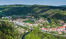
Glatzer boiler

The Glatzer Kessel (Polish Kotlina Kłodzka , Czech Kladská kotlina ) is a geographical name for an area within the former county of Glatz . Since the end of the war in 1945, the area largely corresponds to the Polish powiat Kłodzki . From a petrological and tectonic point of view, it belongs to the landscape of the Inner Sudetian Depression .
The name Glatzer Kessel denotes the fact that the hilly country with a north-south extension of about 50 km is surrounded by mountains that form its natural borders. These are the Owl Mountains ( Góry Sowie ) and the Warthagebirge ( Góry Bardzkie ) in the north, the Reichenstein Mountains ( Góry Złote ) and the Bielengebirge ( Góry Bialskie ) in the east and the Glatzer Snow Mountains ( Masyw Śnieżnika ) in the southeast . In the southwest are the Habelschwerdter Mountains ( Góry Bystrzyckie ) and the Eagle Mountains ( Góry Orlickie ) and in the northwest the Heuscheuergebirge ( Góry Stołowe ).
The Glatzer Kessel is traversed by the Glatzer Neisse and its tributaries, the Habelschwerdter Weistritz , Reinerzer Weistritz and Steine as well as the Landecker Biele . The Glatzer Neisse flows over the Oder into the Baltic Sea .
This part historically belonged to the Königgrätzer Kreis in Bohemia . In 1459 this area was raised to a county by the Bohemian King George of Podebrady and thus a subsidiary of the Crown of Bohemia .
The western area of the Glatzer Land is geographically outside the Glatzer Kessel, on the other side of the watershed . It is open to Bohemia and belongs geomorphologically to the Bohemian Basin . This area is reached via the Hummelpass, which runs between the Habelschwerdter and Heuscheuer mountains. Historically, it and the villages of the Bohemian Angle belonged to the Hummel dominion . Their area belonged to the East Bohemian rule Náchod, which was also incorporated into the Königgrätzer district. In 1477 Georg von Podiebrad's son Heinrich d. Ä. this area in his county of Glatz. It drains into the Metuje ( Mettau ) and reaches the North Sea via the Elbe .
Due to the easily accessible passes from Mittelwalde ( Międzylesie ) to Moravia and over the Hummelpass and Náchod to Bohemia and the Nissa Gorge ( Nysa Kłodzka ) near Wartha ( Bardo ) as a connection to Silesia , the area has been a transit or connection country between Bohemia since ancient times and Silesia.
While it was part of Prussia , the county of Glatz consisted of the districts of Glatz , Habelschwerdt and, at times, Neurode . After the Second World War, the entire area fell to Poland .
literature
- František Musil: Vrcholná kolonizace a východní Čechy . In: Ondřej Felcman (ed.): Dějiny východních Čech , Praha 2009, ISBN 978-80-7422-003-6 , pp. 340-344
Web links
- http://www.grafschaft-glatz.de/kultur/kultur01.htm
- http://www.grafschaft-glatz.de/kultur/kultur00.htm#GEOGR
See also
Coordinates: 50 ° 15 ′ 0 ″ N , 16 ° 40 ′ 0 ″ E


