Heuscheuergebirge
| Heuscheuergebirge | ||
|---|---|---|
|
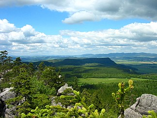
In the Heuscheuergebirge (view from Szczeliniec Wielki ) |
||
| Highest peak | Big hay barn ( 919 m npm ) | |
| location | Poland | |
| part of | Sudeten | |
|
|
||
| Coordinates | 50 ° 28 ′ N , 16 ° 20 ′ E | |
The Heuscheuergebirge (Polish Góry Stołowe , Czech Stolové hory , also Hejšovina ) is part of the middle Sudetes in Poland . It belongs to the Glatzer Kessel in Lower Silesia in the western part of the former County of Glatz . In the west and north it borders directly on the Czech Republic , where some foothills extend. It is under special protection as the Góry Stołowe National Park .
geography
The Heuscheuergebirge is bordered in the southeast by the Adlergebirge and the Habelschwerdter Gebirge , from which it is separated by the valley of the Reinerzer Weistritz ( Bystrzyca Dusznicka ) and the Hummelpass. In the south run the Wzgórza Lewinskie ( Lewiner Uplands ) and in the northwest the elongated mountain range of the Falkengebirge ( Broumovské Stěny ) joins the 773 m high Barzdorf Spitzberg ( Božanovský Špičák ). The wide river valley of the stones ( Ścinawka ) lies between the Heuscheuergebirge and the Eulengebirge to the northeast .
The starting point for the Heuscheuer is Karłów ( Karlsberg ), which is located below the Great Heuscheuer and can be reached via the 387 voivodship road. Which belongs to the rock city Heuscheuergebirge Błędne Skały ( Wilde holes ; Czech "Divoké Doury") is achieved via a branch or alternatively via Czermna ( Tscherbeney ) of Bukowina Kłodzka ( Bukowine ) from.
The Heuscheuergebirge is surrounded by the villages Pasterka ( Passendorf ) in the north, Radków ( Wünschelburg ) and Ratno Dolne ( Niederrathen ) in the northwest, Wambierzyce ( Albendorf ) in the east, Polanica-Zdrój ( Bad Altheide ) and Szczytna ( Rückers ) in the southeast, Łężyce ( Friedersdorf ), Duszniki-Zdrój ( Bad Reinerz ) and Lewin Kłodzki ( Lewin ) in the south, Jeleniów ( Gellenau ), Kudowa-Zdrój ( Bad Kudowa ) and Czermna in the southwest and Pstrążna ( Strausseney ) and Ostra Góra ( Nauseney ) in the west.
Beyond the border with the Czech Republic, which runs in the west and north of the Heuscheuergebirge, are Žďárky ( Kleinbrand ) and Vysoká Srbská ( Hochsichel ) in the west, Nízká Srbská ( Niedersichel ), Bezděkov ( Bösig an der Mettau ) and Machov ( Machau ) in the northwest as well Božanov ( Barzdorf ) and Otovice ( Ottendorf ) in the northeast.
The watershed between the Baltic and North Seas runs through the Heuscheuergebirge . The streams in the eastern half of the mountain flow to the stones and the Reinerzer Weistritz and thus into the Baltic Sea. The creeks in the western half of the mountain drain via the Židovka ( Sichler Bach ), which rises near the Wild Lochs, and the Czermnica ( Tscherbeeyer Bach ), which flows into the Brlenka as a left tributary , into the Metuje ( Mettau ) and thus the North Sea. The same applies to the right tributaries of the Bystra ( Schnell ) coming from the Heuscheuergebirge , which also flows into the Metuje.
description
The German name of the range is derived from the mesas of the Great Heuscheuer ( 919 m NPM ; polish Szczeliniec Wielki , Czech Velká Hejšovina ), and Small Heuscheuer ( 895 m NPM ; polish Szczeliniec Mały from which with its shape to huge hay) Scrub remember and also represent the highest elevations. The Polish name Góry Stołowe, however, means "table mountains". The mountains feature numerous striking sandstone cliffs that form dramatic crevices , gorges and towers.
The Heuscheuergebirge was opened up for tourism by Franz Pabel from Karlsberg in 1790 and visited in the same year by the Prussian King Friedrich Wilhelm II . In order to secure the Prussian border to Bohemia, the king had Fort Karl built on the Große Heuscheuer , which he had commissioned the major and later General Bonaventura von Rauch to do. Major von Rauch was able to receive Johann Wolfgang von Goethe there on August 28, 1790, the poet's 41st birthday . After Goethe had climbed the hay barn as part of his multi-week trip to Silesia , he then wrote a geological description.
The climbing is limited in Heuscheuergebirge possible.
Attractions
- Wambierzyce pilgrimage site ( Albendorf )
- Open-air museum of folk architecture in Pstrążna ( Strausseney ), with faithfully rebuilt farmhouses from the area
- Skull Chapel ( Kaplicza czaszek ) in Czermna
- Rock formations
literature
- Tourist map : Broumovsko, Góry Kamienne a Stołowe , Club Českých Turistů 1998, ISBN 80-85499-46-0
- Mapa Turystyczna: Góry Stołowe , PPWK 1989
- Johann Wolfgang von Goethe: From the notebook from the Silesian journey. In: Goethe Works, Weimar Edition III. Section Volume 2: July – September 1790, 1887
- Adalbert Hoffmann: The Goethe Day of the Schneekoppe and the Heuscheuer for a new source. In: The hiker in the Giant Mountains. Volume 42 No. 473
- Johann Friedrich Zöllner : Letters about Silesia, Krakow, Wieliczka and the County of Glatz. Friedrich Maurer publishing house. Berlin, 1795, p. 433
Web links
Individual evidence
- ↑ mapakultury ( Polish )
- ↑ Overview of parts of the Heuscheuergebirge on db-sandsteinklettern.gipfelbuch.de


