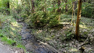
Brlenka
|
Brlenka Brdlenka |
||
|
on the upper course |
||
| Data | ||
| Water code | CZ : 1-01-03-034 | |
| location | Czech Republic ( Královéhradecký kraj ) | |
| River system | Elbe | |
| Drain over | Metuje → Elbe → North Sea | |
| source | east of Vysoká Srbská , Okres Náchod 50 ° 29 ′ 14 ″ N , 16 ° 16 ′ 4 ″ E |
|
| Source height | 598 m nm | |
| muzzle | at Velké Poříčí coordinates: 50 ° 26 ′ 58 ″ N , 16 ° 11 ′ 55 ″ E 50 ° 26 ′ 58 ″ N , 16 ° 11 ′ 55 ″ E |
|
| Mouth height | 354 m nm | |
| Height difference | 244 m | |
| Bottom slope | approx. 27 ‰ | |
| length | approx. 9 km | |
| Catchment area | 32.6 km² | |
| Communities | Vysoká Srbská , Žďárky | |
The Brlenka (also Brdlenka , German also "Berlenkabach") is a left tributary of the Metuje ( Mettau ). The area through which it flows belongs to the Okres Náchod in the Královéhradecký kraj in the Czech Republic. On a short section it flows through the northwestern district of Słone in the powiat Kłodzki in the Lower Silesian Voivodeship in Poland.
description
The Brlenka rises in the western foothills of the Heuscheuergebirge in the Ulehle nature reserve in the Czech Republic, close to the border with Poland. It initially flows westwards between the nature reserves Louka pod Březinou and Bučiny pod Brlenkou , turns to the southwest before Vysoká Srbská and continues through Sedmakovice, where the protected tree monument «Kosova Lipa» is located on the right bank. Before Žďárky it flows as a left tributary of the in Pstrążna springing Pstrążnik ( Straußeneyer Bach , Czech: Strouženský Potok ) to. From the Šulcová hora , which is southeast of Žďárky, the middle of the Brlenka forms the border with Poland for about 600 m. After Brné it flows south and after about 100 m it reaches Polish territory, which belongs to the districts of Słone ( Schlaney / Schnellau ). After less than 200 m, the Czermnica ( Tscherbeeyer water ), which comes from the east and is also referred to as Brlenka from here, flows into it as a left tributary . Then the Brlenka flows west and after about 300 m it reaches Czech territory again, where the Homolka flows into it as a right tributary. After a bend to the southwest, it flows into the Metuje, which comes from the Adršpach-Weckelsdorf rock town , at Velké Poříčí .
Tributaries
- Pstrążnik ( Straußeneyer Bach , Czech: Strouženský potok ) (L)
- Czermnica ( Tscherbeeyer water ; Czech Čermná , also Čermenský potok and Červený potok ) (L)
- Homolka (R)
literature
- Turistická Mapa: Broumovsko, Góry Kamienne a Stołowe , Club Českých Turistů, 1998, ISBN 80-85499-46-0
Web links
Individual evidence
- ↑ mapy.cz
- ↑ a b Rivers in the Elbe catchment area PDF p. 111
- ↑ Marek Šebela, Jiři Fišer: České Názvy hraničních Vrchů, Sídel a vodních toků v Kladsku . In: Kladský sborník 5, 2003, p. 394
- ↑ Kosova Lipa
- ↑ The border in the Brlenka ( Berlenkabach ), s. No. 26
