Glatz district
| Glatz district | |
|---|---|
| Coat of arms county | |
| Prussian Province |
Silesia (1816–1919, 1938–1941) Lower Silesia (1919–1938, 1941–1945) |
| Administrative district | Wroclaw |
| County seat | Bald |
| Last district administrator | Heinrich Klosterkemper (1937–1945) |
| surface | 852.37 km² (1939) |
| Residents | 123,130 (1939) |
| Population density | 144 inhabitants / km² (1939) |
| Cities | 5 |
| Rural communities | 96 |

|
|
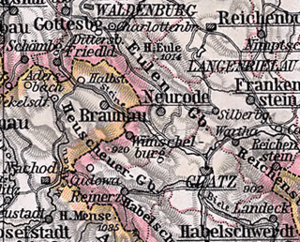
| The district of Glatz within the boundaries from 1855 to 1932 | |
The Prussian district Glatz in Silesia existed in different delimitations from 1742 to 1945. Its district town was the town of Glatz . The former district area is now part of the powiat Kłodzki in the Polish Lower Silesian Voivodeship .
Administrative history
Kingdom of Prussia
After the conquest of most of Silesia by Prussia in 1741, the royal cabinet order of November 25, 1741 introduced the Prussian administrative structures in Lower Silesia . This included the establishment of two war and domain chambers in Breslau and Glogau as well as their subdivision into districts and the appointment of district administrators on January 1, 1742.
The Glatz district was formed from the county of Glatz , and Ernst Anton von Pannwitz was appointed as its first district administrator . The district of Glatz was the largest Silesian district in terms of both area and population in the 18th century and was divided into the six districts of Glatz, Habelschwerdt, Landeck, Lewin, Neurode and Wünschelburg. It belonged to the Wroclaw War and Domain Chamber until it was assigned to the Reichenbach administrative district of the province of Silesia in the course of the Stein-Hardenberg reforms in 1815 .
On January 1, 1818, the new Habelschwerdt district was formed from the two districts of Habelschwerdt and Landeck in the district of Glatz . After the dissolution of the Reichenbach administrative district, the Glatz and Habelschwerdt districts were assigned to the Breslau administrative district on May 1, 1820 .
On August 2, 1855, the Neurode district was formed from the Neurode and Wünschelburg districts of the Glatz district, with its seat in the city of Neurode.
German Empire
After the German War , the German Confederation was dissolved under pressure from Bismarck . Since July 1, 1867, Prussia has been the dominant power of the newly founded North German Confederation , which became the German Empire on January 1, 1871 .
On November 8, 1919, the province of Silesia was divided into two parts. The new province of Lower Silesia was formed from the administrative districts of Breslau and Liegnitz. On September 30, 1929, in the Glatz district, as in the rest of Prussia, almost all previously independent manor districts were dissolved and assigned to neighboring rural communities. On October 1, 1932, the Neurode district was dissolved again and merged with the Glatz district. At the same time, the rural communities of Neu Wilmsdorf were reclassified from the Habelschwerdt district and Wiltsch from the Frankenstein district to the Glatz district.
On April 1, 1938, the Prussian provinces of Lower Silesia and Upper Silesia were reunited to form the Province of Silesia, but this was reversed on January 18, 1941. On January 1, 1939, the Glatz district was given the name Landkreis in accordance with the now unified regulation .
In the spring of 1945 the district was occupied by the Red Army . In the summer of 1945, the district was placed under Polish administration by the Soviet occupying power in accordance with the Potsdam Agreement . The influx of Polish civilians then began in the district area, mainly from the areas east of the Curzon Line that had fallen to the Soviet Union as part of the “ westward displacement of Poland ” . In the period that followed, most of the German population was expelled from the district .
Population development
| year | Residents | source |
|---|---|---|
| 1803 | 101,919 | |
| 1819 | 61,433 | |
| 1846 | 91,066 | |
| 1871 | 60,407 | |
| 1885 | 64,442 | |
| 1900 | 60,819 | |
| 1910 | 64,852 | |
| 1925 | 66,905 | |
| 1939 | 123.130 |
District administrators
|
|
Local constitution
Since the 19th century, the Glatz district has been divided into cities, rural communities and manor districts . With the introduction of the Prussian Municipal Constitutional Act of December 15, 1933, there was a uniform municipal constitution for all Prussian municipalities from January 1, 1934. With the introduction of the German municipal code of January 30, 1935, the leader principle was enforced on April 1, 1935 at the municipal level . A new district constitution was no longer created; The district regulations for the provinces of East and West Prussia, Brandenburg, Pomerania, Silesia and Saxony from March 19, 1881 continued to apply.
Communities
The district of Glatz last comprised five cities and 96 rural communities:
The uninhabited forest district Reinerz also belonged to the district. The following incorporations took place in the district up to 1937:
|
|
Place names
In the interwar period , several parishes were renamed, including a. seven places from the Bohemian angle :
|
geography
The district last corresponded approximately to the northern half of the former County of Glatz and has a geographical latitude of 50.3 ° –50.6 ° and longitude 16.2 ° –17 °. Together with the district of Habelschwerdt, it formed the Glatzer basin in the south-west of Lower Silesia, which is surrounded by mountains . The mountains surrounding the district were:
- Owl Mountains ( Góry Sowie )
- Reichensteiner Mountains ( Góry Złote )
- Kłodzko Snow Mountains ( Masyw Śnieżnika )
- Bielen Mountains ( Góry Bialskie ),
- Eagle Mountains ( Góry Orlickie ; Czech. Orlicke hory )
- Habelschwerdter Mountains ( Góry Bystrzyckie ) and
- Heuscheuergebirge ( Góry Stołowe , Czech. Stolové hory )
literature
- Gustav Neumann : Geography of the Prussian State. 2nd edition, Volume 2, Berlin 1874, pp. 209–210, paragraph 23.
- Royal Statistical Bureau: The municipalities and manors of the Province of Silesia and their people. Based on the original materials of the general census of December 1, 1871. Berlin 1874, pp. 146–153 ( facsimile in the Google book search).
- Friedrich Gottlob Leonhardi : Earth description of the Prussian monarchy , Volume 3, part, Halle, pp. 207-264 .
- M. Rademacher: German administrative history from the unification of the empire in 1871 to the reunification in 1990. (online material for the dissertation, Osnabrück 2006)
Web links
Individual evidence
- ^ Roland Gehrke: State Parliament and the Public: Provincial Parliamentarism in Silesia 1825-1845 . Böhlau Verlag, Cologne 2009, ISBN 978-3-412-20413-6 , pp. 45 ( partially digitized ).
- ^ A b c d Klaus Huebner: The county of Glatzer districts - On the administrative history of the Glatzer country . In: Arbeitsgemeinschaft Grafschaft Glatz (Ed.): AGG-MITTEILUNGEN . No. October 15 , 2016, ISSN 1610-1308 ( digital copy [PDF]).
- ^ Rolf Straubel : Biographical manual of the Prussian administrative and judicial officials 1740–1806 / 15 . In: Historical Commission to Berlin (Ed.): Individual publications . 85. KG Saur Verlag, Munich 2009, ISBN 978-3-598-23229-9 .
- ^ Ordinance on the division of the Prussian state according to its new delimitation . 1815 ( digitized ).
- ^ Roman Kamionka: The reorganization of the district division of Silesia in the Stein-Hardenberg reform period , Breslau 1934.
- ↑ a b Official Gazette of the Royal Government of Breslau 1855, No. 33 . Establishment of the Neurode district. Breslau, S. 237 f . ( Digitized version ).
- ↑ Walther Hubatsch (ed.): Outline of German administrative history 1815-1945. Row A: Prussia. Volume 4: Dieter Stüttgen: Silesia. Johann Gottfried Harder Institute, Marburg / Lahn 1976, ISBN 3-87969-116-9 .
- ↑ Georg Hassel: Statistical outline of all European states . The statistical view and special statistics of Central Europe. Vieweg, Braunschweig 1805, p. 39 ( digitized version ).
- ^ Statistisches Bureau zu Berlin (Ed.): Contributions to the statistics of the Prussian state . Duncker & Humblot, Berlin 1821, Silesia, p. 89 ( digitized version ).
- ↑ Royal Statistical Bureau (ed.): Mittheilungen des Statistisches Bureau's in Berlin, Volume 2 . Population of the districts. ( Digitized version ).
- ^ The municipalities and manor districts of the Prussian state and their population 1871
- ^ Community encyclopedia for the province of Silesia 1885
- ↑ a b www.gemeindeververzeichnis.de
- ^ A b Michael Rademacher: German administrative history from the unification of the empire in 1871 to the reunification in 1990. glatz.html. (Online material for the dissertation, Osnabrück 2006).
- ^ Administrative history of the district of Glatz and the list of district administrators on the website territorial.de (Rolf Jehke), as of July 26, 2013.

