
Głogów
| Głogów Glogau |
|||
|---|---|---|---|

|
|
||
| Basic data | |||
| State : | Poland | ||
| Voivodeship : | Lower Silesia | ||
| Powiat : | Głogów | ||
| Area : | 35.37 km² | ||
| Geographic location : | 51 ° 40 ′ N , 16 ° 5 ′ E | ||
| Residents : | 67,317 (Jun. 30, 2019) |
||
| Postal code : | 67-200 to 67-210 | ||
| Telephone code : | (+48) 76 | ||
| License plate : | DGL | ||
| Economy and Transport | |||
| Street : | Przemków - Leszno | ||
| Rail route : | PKP routes Wroclaw – Stettin and Łódź – Forst (Lausitz) | ||
| Next international airport : | Wroclaw | ||
| Gmina | |||
| Gminatype: | Borough | ||
| Surface: | 35.37 km² | ||
| Residents: | 67,317 (Jun. 30, 2019) |
||
| Population density : | 1903 inhabitants / km² | ||
| Community number ( GUS ): | 0203011 | ||
| Administration (as of 2015) | |||
| City President : | Rafael Rokaszewicz | ||
| Address: | Rynek 10 67-200 Głogów |
||
| Website : | www.glogow.pl | ||

Głogów , German Glogau (also Groß-Glogau ), is a city in the Polish Voivodeship of Lower Silesia . Głogów is the district town of Powiat Głogowski ( Powiat Glogau ) and forms its own municipality. It is also the seat of Gmina Głogów , a rural community that includes the villages north and east of the city.
geography
Geographical location
The city is located in the northern part of Lower Silesia , around 100 km northwest of the Lower Silesian capital Breslau (Wrocław) , on both sides of the Oder at 83 m above sea level. NHN , with the majority of the urban area concentrated on the left. The development of Glogau on the right bank exists only on the cathedral island. The old town center is on the left bank of the Oder, as are the copper smelters to the west of the town.
Districts
- Biechów (Beichau ; 1937–45: Oderhorst)
- Górkowo (Gurkau)
- Krzepów (Schrepau ; 1937–45: Schwarztal)
- Nosocice (Noßwitz ; 1937–45: Urstetten)
- Wróblin Głogowski (Froebel)
Furthermore, there are in the urban area following settlements: Osiedle Brzostów (Brostau) , Osiedle Chrobry , Osiedle Fabryczna (Weidisch) , Osiedle Hutnik , Osiedle Kopernik , Osiedle Kościuszki , Osiedle Matejki , Osiedle Nadodrze , Osiedle Piastów Śląskich , Osiedle Żarków (Zarkau ; 1937-45: Shipyards) , Żukowice

history
Middle Ages and Early Modern Times

In 1010 the city was first mentioned as urbs Glogua by Thietmar von Merseburg . 150 years later (1157), Duke Bolesław IV, the senior duke of Poland, had the city set on fire because he believed that he could not defend it against Emperor Frederick I Barbarossa . A Glogau collegiate school can be proven from 1233; it was one of the first schools in Silesia. From 1251 Glogau was the residence of the Duchy of Glogau . Two years later, Glogau, which then had over 2,000 inhabitants, received Magdeburg city rights . In 1331 Glogau fell together with the Duchy of Glogau as a fief to the Kingdom of Bohemia .
In 1484 the Sagan Duke Johann II had the Jews expelled from the city and in 1488 seven councilors imprisoned and starved to death. From 1499 to 1506 the city and duchy of Glogau were ruled by the later Polish King Sigismund I , who had received both as a fiefdom from his older brother, the Bohemian King Vladislav II .
In 1630 the construction of fortifications began; the number of inhabitants had fallen from approx. 22,000 to approx. 7,000 due to the destruction of the suburbs. During the Thirty Years War , the city was conquered by Protestants in 1632 and regained by the Counter - Reformation in 1633 . In 1642 the city was considered the main fortress of Silesia and was the location for a supply depot for Imperial Saxon troops. On May 4, 1642, the fortress and the warehouse with 95,000 bushels of grain were conquered and occupied by a Swedish army under Lennart Torstensson and Torsten Stålhandske . After that the Swedish armies advanced further inland and the battle of Schweidnitz broke out .
In the Prussian province of Silesia

.jpg&filetimestamp=20170111143951&)
In early March 1741, during the First Silesian War , Prussian troops stormed the fortress town of Glogau, which from then on belonged to the Kingdom of Prussia . During the war with France on December 3, 1806, Glogau fell into the hands of French troops, who kept it occupied even after the Peace of Tilsit . During the wars of liberation , around 9,000 French occupiers, plagued by cold temperatures of up to −26 degrees in winter, lack of food and desertions, defended the Glogau fortress against Prussian and Russian troops for fourteen months . On April 10, 1814, the 1,800 surviving occupiers under General Jean Grégoire Laplane surrendered to the besiegers.
Around 1900 Glogau had three Protestant and three Catholic churches (including the Gothic cathedral on an island in the Oder ), a synagogue , a royal castle, a state Catholic and a Protestant grammar school, a number of different manufacturing plants and was the seat of a regional court.
Two years after the First World War , on April 1, 1920, the municipality of Glogau, which had previously belonged to the district, was formed into the urban district of Glogau. This gave the previous district of Glogau the name of a district . The district administrator for the district of Glogau continued to have its seat in the city.
On July 1, 1931, parts of the rural communities Brostau, Rauschwitz, Weidisch, Zarkau and Zerbau (1938–1945: Lerchenberg ) from the district of Glogau were incorporated into the city. With effect from March 31, 1938, further parts of the communities Brostau, Rauschwitz and Zarkau from the district of Glogau were incorporated into Glogau. In 1939 the city of Glogau had 33,558 inhabitants, the district of Glogau 62,280 inhabitants.
Until 1945 Glogau was the administrative seat of the district of Glogau in the administrative district of Liegnitz of the Prussian province of Lower Silesia of the German Empire .
Destruction and displacement
_G%C5%82og%C3%B3w_-Ko%C5%9Bci%C3%B3%C5%82_%C5%9Bw._Miko%C5%82aja,_ruina.jpg)
Shortly before the end of the Second World War , Glogau was declared a fortress . The six-week siege of Glogau by the Red Army fell victim to over 90 percent of the buildings and the old town was in ruins. Glogau was placed under Polish administration by the Soviet occupying power in the summer of 1945 . Then began the immigration of Polish migrants, some of them from areas east of the Curzon Line , where they belonged to the Polish minority. The Poles introduced the place name Głogów for Glogau . In the following period, the local German population was expelled from Glogau by the local Polish administrative authority .
After 1945
In 1952, the Glogauer Heimatbund in Hanover , Głogów's twin town, moved into the Hardenberg house .
After 1945 the city developed in the outskirts; the ruined buildings in the old town were demolished. An upswing only followed with the construction of a copper smelter in 1967, which is still the largest industrial company today. The city center remained undeveloped until the 1980s, and since then the city center has also been rebuilt on the original foundations and in imitation of the old town houses.
Demographics
| year | Residents | Remarks |
|---|---|---|
| 1795 | 9991 | including 1791 Jews |
| 1809 | under 10,000 | |
| 1810 | 9489 | including 1752 Jews |
| 1816 | 8087 | including 4,310 Evangelicals, 2,566 Catholics and 1199 Jews |
| 1825 | 9430 | including 5735 Evangelicals, 2573 Catholics, 1122 Jews |
| 1840 | 14,565 | including 2144 active military personnel, of which 9330 Evangelicals, 4254 Catholics, 981 Jews |
| 1867 | 17,960 | on December 3rd |
| 1871 | 18,261 | on December 1st, of which 11,237 Protestants, 6,039 Catholics, 38 other Christians, 947 Jews |
| 1880 | 18,630 | |
| 1885 | 20,027 | |
| 1890 | 20,529 | including 13,614 Evangelicals, 5989 Catholics and 863 Jews |
| 1900 | 22,147 | with the garrison (two battalions of infantry No. 58, a regiment of field artillery No. 41, a battalion of foot artillery No. 6 and a pioneer battalion), of which 6,500 Catholics and 716 Jews |
| 1925 | 26,098 | including 18,386 Evangelicals, 6954 Catholics, fourteen other Christians and 550 Jews |
| 1933 | 28,229 | including 19,770 Evangelicals, 7651 Catholics, five other Christians and 478 Jews |
| 1939 | 30.172 | including 21,135 Evangelicals, 8067 Catholics, 48 other Christians and 123 Jews |
Attractions
Churches
- The oldest church in the city is the St. Nicholas Church , which was first documented in 1309, but was certainly founded earlier. The Gothic brick building dates from the 14th century. Around 1900, St. Nicholas was a Catholic parish church, was already damaged by various fires and became a ruin during World War II, which is now a memorial.
- To the north of the Oder, in the so-called Domvorstadt (Ostrów Tumski), stands the former St. Mary's Cathedral , later a Catholic parish church. The choir dates partly from the 13th century, the main part of the Gothic structure was built from bricks in the 15th and early 16th centuries; the tower collapsed at the beginning of the 19th century and was rebuilt from 1838 to 1842.
- The late baroque Corpus Christi church with two towers stands near the market square; this former Jesuit church later served as a Catholic garrison church and was restored after the World War.
- The St. Laurentius Church dates from the 16th century.
- The Protestant church "Zur Hütte Christi" was built after the Peace of Westphalia as the first of three Silesian peace churches from 1651 to 1652 outside the city walls. After a collapse in 1654, it was rebuilt in 1655 as a three-aisled hall church based on a design by the architect Albrecht von Säbisch. In 1758 she fell victim to a fire.
- The Protestant church "Schifflein Christi" in the city center southwest of the parish church was built between 1764 and 1772 as a replacement for the church of peace that had burned down. The design came from the Landeshut architect Carl Gotthard Langhans . It was damaged at the end of the war in 1945 and the ruins were torn down in the 1960s. In its place there has been a memorial since 2003, which traces the floor plan of the building with low walls.
- A memorial today also commemorates the city's former synagogue .

Ruins of the St. Nicholas Church
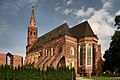
St. Mary's Cathedral

The Corpus Christi Church

Saint Lawrence Church
Memorial at the site of the Protestant church

.jpg)


Other structures
- The town hall on the former market square or ring was rebuilt in the 19th century in a historicizing style; the council tower , formerly the tallest building in the city, was built in 1720 with a baroque helmet roof. Both were restored after the destruction of the Second World War.
- In contrast, the neighboring former municipal theater, also named Andreas-Gryphius-Theater after the city's great son , is in ruins to this day. The theater has been rebuilt since July 2017. The work should be completed in November 2018, so that performances in the theater building can start from 2019. The total cost is around 20 million zlotys. The outer facade of the theater is being reconstructed and the historical building fabric that has been preserved is integrated.
- The former castle of the Dukes of Glogau , later a royal castle and district court, on the banks of the Oder opposite the cathedral suburb , has been restored and now houses an archaeological museum. Only a round tower, the so-called Hunger Tower , bears witness to the original medieval construction ; the main part of the building dates from the 18th and 19th centuries. Century.
- From the former city fortifications (partially reconstructed) remains of the medieval city walls and a moat from the 17th century as well as an artillery tower from the 19th century have been preserved.
- On other buildings z. For example, today's Zespół Szkół Zawodowych is worth seeing, a technical vocational school that was inaugurated in 1909 as an upper secondary school . The then Glogau city planner Wilhelm Wagner designed the architecture with echoes of the Silesian-Bohemian variety of the Baroque .
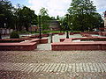
- Behind the former chateau, on the site of the former chateau park, there is an extraordinary modern park with a memorial to the children of Głogów and other memorials.
- East of Glogów is a 221 meter high chimney that was once part of a power station and is now used as a radio tower.

Town hall with tower

Former castle, now a museum

Medieval city wall (reconstruction)
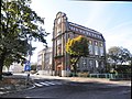
Zespół Szkół Zawodowych (Vocational School)

Bird's eye view of the park

.jpg)
_G%C5%82og%C3%B3w_--_Obwarowania_miejskie.jpg)
.jpg)

politics
City President
At the head of the city administration is the city president . Since 2014 this has been Rafael Rokaszewicz, who was previously the star of the Powiat Głogowski . He is a member of the left-wing SLD but has his own election committee. The regular election in October 2018 led to the following results:
- Rafael Rokaszewicz (Election Committee Rafael Rokaszewicz) 61.2% of the vote
- Przemysław Bożek ( Prawo i Sprawiedliwość ) 31.6% of the vote
- Sławomir Majewski ( Koalicja Obywatelska ) 7.2% of the vote
Rokaszewicz was thus re-elected for a further term in the first ballot.
City council
The city council has 23 members who are directly elected. The election in October 2018 led to the following result:
- Election Committee Rafael Rokaszewicz 41.8% of the vote, 10 seats
- Prawo i Sprawiedliwość (PiS) 36.3% of the vote, 9 seats
- Koalicja Obywatelska (KO) 21.8% of the vote, 4 seats
Town twinning

- Amber Valley in Derbyshire, UK
- Eisenhüttenstadt in the state of Brandenburg (Germany)
- Laholm (Sweden)
- Langenhagen in Lower Saxony (Germany)
- Middelburg in the province of Zeeland (Netherlands)
- Kamianets-Podilskyj (Ukraine)
- Riesa in Saxony (Germany)
traffic
Several regional roads run through Glogau. The largest, the Droga krajowa 12 state road, runs in a north-west direction and forms the only overpass on the Oder in the old town center. Other regional roads are the Droga wojewódzka 292 and Droga wojewódzka 329 roads .
The Głogów station is located at the intersection of the Wrocław – Szczecin railway with the Łódź – Forst (Lausitz) railway, which is only operated here for goods traffic .
Personalities
sons and daughters of the town
- Henry I the Bearded (around 1165 - 1238), Duke of Silesia and Senior Duke of Poland
- Johann von Glogau (around 1445 - 1507), philosopher and mathematician at the University of Krakow
- Hieronymus Schulz (around 1460 - 1522), Bishop of Brandenburg and Havelberg
- Franz Ursinus (1569–1615), titular bishop of Nicopolis and auxiliary bishop in Breslau
- Johannes Neldel (1554–1612), rhetorician, logician, jurist and philosopher
- Andreas Gryphius (1616–1664), poet
- Bernhard Rosa (1624–1696), abbot of the Cistercian monastery of Grüssau
- Paul Winkler (1630–1686), lawyer and writer
- Christian Anton Philipp Knorr von Rosenroth (1653–1721), lawyer and poet
- Johann Christoph Ettner (1654–1724), physician and writer
- Johann Ernst Hartmann (1726–1793), German-Danish musician and composer
- Johann Heinrich von Frankenberg (1726–1804), Roman Catholic cardinal
- Johann Anton von Dessaunieres (1731–1802), Prussian major general and most recently in command of Glogau.
- Saul Berlin (1740–1794), Jewish scholar
- Benjamin Gottlieb Müller (around 1752–1816), politician, mayor of Breslau
- Carl Leopold Gottfried Sattig (1774–1844), notary, consultant and royal judiciary in Glogau, honorary citizen of the city of Glogau
- August Knappe von Knappstädt (1775–1852), Prussian major general
- Amalie von Béguelin b. Cramer (1778–1848), Salonière in Berlin
- Heymann Arnheim (1796–1869), rabbi, collaborator with Leopold Zunz
- Heinrich Förster (1799–1881), Prince-Bishop of Breslau
- Friedrich Wilhelm August Vetter (1799 – unknown), physician and balneologist in Berlin
- Carl Ernst Rudolf von Gersdorff (1803–1876), manor owner and politician, member of the Frankfurt National Assembly 1848/1849
- Friedrich Wilhelm Eduard Herkt (1805–1877), Prussian lieutenant general
- Salomon Munk (1805-1867), orientalist
- Hugo Leopold Wilhelm Sattig (1807–1884), Lord Mayor of the City of Görlitz
- Michael Sachs (1808–1864), rabbi in Prague and Berlin
- Ernst Ewald Albert Hofferichter (1809 – after 1872), member of the Prussian National Assembly, head of the Glogau city council and member of the local council
- Carl Richtsteig (1809–1879), politician, Lord Mayor of the city of Görlitz
- Wilhelm Heinrich Erbkam (1810–1884), Protestant theologian
- Robert Berndt (1811–1888), lawyer, mayor of the city of Glogau and member of the Prussian House of Representatives and Prussian Mansion.
- Georg Erbkam (1811–1876), architect
- Alexander von Eckartsberg (1815–1896), Prussian major general and commander of the 22nd Infantry Brigade
- Alfons Girodz von Gaudi (1818–1888), Prussian lieutenant general
- Paulus Stephanus Cassel (1821-1892), journalist, theologian and writer
- Benno Regely (1825–1888), Prussian lieutenant general
- Hermann Zopff (1826–1883), musicologist and composer
- Sigismund Ludwig Borkheim (1826–1885), revolutionary 1848/49 and publicist
- Valeska von Gallwitz (1833–1888), writer
- Werner von der Schulenburg (1836–1903), Lieutenant General
- Arthur von Posadowsky-Wehner (1845–1932), politician, Vice Chancellor of the German Empire
- Georg von Dyherrn (1848–1878), poet and novelist
- Alberta von Puttkamer (1849–1923), writer
- Georg von Gizycki (1851–1895), philosopher and university professor
- Richard Knötel (1857–1914), history painter
- Georg Hoffmann (1858 – after 1899), administrative lawyer and district administrator
- Karl von Lewinski (1858–1937), officer and holder of the order Pour le Mérite
- Bernhard von Hindenburg (1859–1932), officer and writer
- Georg Friedrich Carl Rörig (1864–1941), agricultural scientist, agricultural zoologist and pioneer of bird protection
- Franz Triebs (1864–1942), canon lawyer
- Martin Richter (1869–1930), administrative lawyer
- Walter Friedlaender (1873–1966), art historian
- Ludwig Ferdinand von Wolff (1874–1952), mineralogist
- Hermann Hoffmann (1878–1972), Catholic theologian
- Joachim von Stülpnagel (1880–1968), General
- Hans Joachim von Reitzenstein (1881–1935), writer
- Felix Stern (1884–1942), neurologist
- Hans Weisbach (1885–1961), conductor and pianist
- Wilhelm Kube (1887–1943), politician (NSDAP), Gauleiter Brandenburg
- Arnold Zweig (1887–1968), writer
- Paul Graetz (1890–1937), cabaret artist and film actor
- Carl-Hans Graf von Hardenberg (1891–1958), land manager, officer and resistance fighter against National Socialism
- Felix Tikotin (1893–1986), art dealer and art collector
- Paul Krause (1905–1950), politician of the German Center Party, Member of the Bundestag
- Arnold Hitzer (1902–1977), theologian and member of the Confessing Church
- Helmut Körnig (1905–1972), athlete
- Helmut Bischoff (1908–1993), SS leader
- Herbert Bischoff (1910 - unknown, after 1970), SS leader
- Hans-Wilhelm Buchholz (1910–2002), surgeon and founder of the clinic
- Friedrich Heuck (1921–2019), doctor and university professor
- Franz D. Lucas (1921–1998), businessman and historian
- Arno Schulz (1924–2008), German-Austrian computer scientist
- Eberhard Werner (1924–2002), landscape painter
- Hans-Werner Gille (* 1928), historian, author and journalist
- Heino Schubert (1928–2018), composer
- Konrad Feiereis (1931–2012), Roman Catholic clergyman, theologian and religious philosopher
- Klaus Hoffmann-Reicker (* 1939), writer, publicist and historian
- Klaus Rosenzweig (1939–2014), administrative lawyer
- Horst Hawemann (1940–2011), theater director
- Friedemann W. Golka (1942–2011), Protestant theologian
- Heiner Willenberg (* 1942), Germanist
- Rainer Zimmermann (* 1942), handball player
- Sylwester Chruszcz (* 1972), politician and member of the European Parliament for the League of Polish Families
- Tomasz Markowski (* 1975), chess master
- Piotr Farfał (* 1978), politician of the League of Polish Families
- Marta Michna (* 1978), German chess player of Polish origin
People connected to the city
- Jean-Martin de Prades (approx. 1720–1782), exiled French theologian and contributor to the Encyclopédie
- Simon Heinrich Sack (1723–1791), Royal Prussian Court and Justice Commission Council in Glogau, founder of the Hofrat Simon Heinrich Sack's Family Foundation
- Karl Ludwig von Cocceji (1724–1808), Prussian Higher Government President von Glogau
- Carl Christoph Cramer (1750–1827), tax collector in Glogau, holder of the concession for the coffee trade in Silesia, Royal Prussian Councilor
- Heinrich von Béguelin (1765–1818), Prussian tax clerk and employee of the Prussian Minister Freiherr vom Stein
- Karl Ludwig Severin (1785–1851), Prussian prorector, poet and philologist
- Heinrich von Buddenbrock (1797-1859), Prussian major general, in 1851 he became commandant of Glogau
- Gustav Waldemar von Rauch (1819–1890), Prussian lieutenant general and commander, later general of the cavalry
- Theodor Blätterbauer (1823–1906), German painter, graphic artist and drawing teacher at the Liegnitz Knight Academy
- Hugo Ulrich (1827–1872), German romantic composer and arranger
- Oskar Hellmann (1869–1944), city chronicler and publisher in Glogau
- Arnold Hasse (1873–1933), Lord Mayor
- Arthur Lieutenant (1884–1968), Lord Mayor, Finance Minister of the State of Brandenburg, Member of the People's Council of the Soviet Zone
- Helmut Schoepke (1903–1996), publisher and poet
- Karl Brückner (1904–1945), owner of a cigar shop, member of the Reichstag and NSDAP district leader
See also
literature
- Julis Blaschke: History of the city of Glogau and the Glogau country . Publishing house Oskar Hellmann , Glogau 1913.
- Johann Georg Knie : Alphabetical-statistical-topographical overview of all villages, towns, cities and other places in the royal family. Prussia. Province of Silesia . Breslau 1830, pp. 928-929.
- Johann Georg Knie : Alphabetical-statistical-topographical overview of the villages, towns, cities and other places of the royal family. Preusz. Province of Silesia. 2nd Edition. Graß, Barth and Comp., Breslau 1845, pp. 821-824 .
- Ferdinand Minsberg: History of the city and fortress Groß-Glogau . Volume 2, Glogau 1853 ( e-copy ).
- Dehio Handbook of Art Monuments in Poland. Silesia. Deutscher Kunstverlag, Munich et al. 2005, ISBN 3-422-03109-X , pp. 298–305.
- Robert Berndt : History of the Jews in Gross-Glogau , G. Müller, Glogau o. J. (1874), Online PDF, 45 MB
- Robert Berndt: History of the city of Gross-Glogau during the first half of the seventeenth century, namely during the Thirty Years War , G. Müller, Glogau 1879.
- Robert Berndt: History of the town of Gross-Glogau from the end of the Thirty Years' War to the French march in 1814 , G. Müller, Glogau 1882.
- Robert Berndt: History of the city of Gross-Glogau. 2. Continuation: From the evacuation of Glogau by the French to the end of the reign of King Friedrich Wilhelm IV. , G. Müller, Glogau 1886.
- Hermann Hoffmann: Glogau bishops. In: Festschrift for the triple centenary 1626–1926 of the State Catholic High School in Glogau. Breslau 1926, pp. 73-105.
Web links
- Glogow.info. City of Glogau, accessed on October 31, 2015 (Polish).
- Twierdza Głogów (Glogau Fortress). Retrieved October 31, 2015 (Polish).
- Christian Schmidt-Häuer: The Wise Men from Glogau: In the Silesian city, Germans and Poles put a joint memorial to the victims of the expulsions. Zeit Online , Die Zeit No. 45/2003, October 30, 2003, accessed on October 31, 2015 .
- Michael Rademacher: German administrative history from the unification of the empire in 1871 to the reunification in 1990. City and district of Glogau (Polish: Glogów). (Online material for the dissertation, Osnabrück 2006).
- History of the city of Glogau. Glogauer Heimatbund eV, accessed on October 31, 2015 .
Individual evidence
- ↑ a b population. Size and Structure by Territorial Division. As of June 30, 2019. Główny Urząd Statystyczny (GUS) (PDF files; 0.99 MiB), accessed December 24, 2019 .
- ^ City website, Prezydent , accessed May 6, 2017
- ↑ Kazimierz Bobowski: Origin and development of different Silesian schools in the Middle Ages. In: Würzburger medical history reports 23, 2004, pp. 471–485; here: p. 483.
- ^ Lothar Höbelt: From Nördlingen to Jankau. Imperial strategy and warfare 1634-1645 . In: Republic of Austria, Federal Minister for State Defense (Hrsg.): Writings of the Heeresgeschichtliches Museum Wien . tape 22 . Heeresgeschichtliches Museum, Vienna 2016, ISBN 978-3-902551-73-3 , p. 324 .
- ↑ Großer Generalstab (Ed.): 1806 - The Prussian officer corps and the investigation of the war events. Ernst Siegfried Mittler and Son, Berlin 1906, pp. 40, 45
- ↑ a b Meyer's Large Conversation Lexicon . 6th edition, Volume 8, Leipzig / Vienna 1907, pp. 45–46.
- ↑ a b c d e f g Michael Rademacher: German administrative history from the unification of the empire in 1871 to the reunification in 1990. glogau.html. (Online material for the dissertation, Osnabrück 2006).
- ↑ Helmut Knocke : Hardenbergsches Haus. In: Klaus Mlynek, Waldemar R. Röhrbein (eds.) U. a .: City Lexicon Hanover . From the beginning to the present. Schlütersche, Hannover 2009, ISBN 978-3-89993-662-9 , p. 270.
- ↑ Wolfgang Jäger : Geographisch-Historisch-Statistisches Zeitungs-Lexikon . Volume 1: A - H , Nuremberg 1805, pp. 787-788.
- ↑ Ferdinand Minsberg: history of the city and fortress of Great Glogau . Volume 2, Glogau 1853, p. 290
- ↑ a b A. A. Mützell (Ed.): New topographical-statistical-geographical dictionary of the Prussian state . Volume 6, Halle 1825, pp. 28–30.
- ↑ Johann Georg Knie : Alphabetical-statistical-topographical overview of the villages, spots, cities and other places of the royal family. Prussia. Province of Silesia, including the Margraviate of Upper Lusatia, which now belongs entirely to the province, and the County of Glatz; together with the attached evidence of the division of the country into the various branches of civil administration. Melcher, Breslau 1830, pp. 928-929 .
- ^ Johann Georg Knie : Alphabetical-statistical-topographical overview of the villages, spots, cities and other places of the royal family. Preusz. Province of Silesia. 2nd Edition. Graß, Barth and Comp., Breslau 1845, pp. 821-824 .
- ^ A b Royal Statistical Bureau: The municipalities and manor districts of the province of Silesia and their population. Based on the original materials of the general census of December 1, 1871. Berlin 1874, pp. 192–193, item 1 .
- ↑ Historical information based on Glogau. A guide through town and district , edited by R. Scholz and P. Knötel, Verlag von Carl Flemming, Glogau o. J. [between 1892 and 1895], pages 1–7. The topicality was checked on the basis of the articles in the English and Polish Wikipedia as well as the image material on Commons .
- ↑ See Kościół Łódź Chrystusowa w Głogowie in the Polish Wikipedia.
- ↑ According to Scholz / Knötel, Glogau , p. 2.
- ↑ Reconstruction of the theater Accessed on February 25, 2018 (Polish)
- ↑ Pictures for the reconstruction of the theater (Polish)
- ↑ According to Scholz / Knötel, Glogau , p. 5f.
- ↑ Zespół Szkół Zawodowych in the Polish Wikipedia
- ^ According to Zespół Szkół Zawodowych w Głogowie in the Polish Wikipedia and the school's website .
- ↑ See Biblioteka Świętego Pielgrzyma and Pomnik Dzieci Głogowskich w Głogowie in the Polish Wikipedia.
- ↑ Result on the website of the election commission, accessed on August 26, 2020.
- ↑ Result on the website of the election commission, accessed on August 26, 2020.
- ↑ CV Arnhem at napoleon epoch- checked on June 8, 2017

.jpg&filetimestamp=20170111143951)