Kamienna Góra
| Kamienna Góra | ||
|---|---|---|

|
|
|
| Basic data | ||
| State : | Poland | |
| Voivodeship : | Lower Silesia | |
| Powiat : | Kamienna Góra | |
| Area : | 18.00 km² | |
| Geographic location : | 50 ° 47 ' N , 16 ° 2' E | |
| Height : | 468 m npm | |
| Residents : | 19,010 (Jun. 30, 2019) |
|
| Postal code : | 58-400 to 58-402 | |
| Telephone code : | (+48) 75 | |
| License plate : | DKA | |
| Economy and Transport | ||
| Street : | Legnica - Trutnov | |
| Rail route : | Sędzisław – Lubawka | |
| Next international airport : | Wroclaw | |
| Gmina | ||
| Gminatype: | Borough | |
| Surface: | 18.00 km² | |
| Residents: | 19,010 (Jun. 30, 2019) |
|
| Population density : | 1056 inhabitants / km² | |
| Community number ( GUS ): | 0207011 | |
| Administration (as of 2015) | ||
| Mayor : | Janusz Chodasewicz | |
| Address: | pl. Grunwaldzki 1 58-400 Kamienna Góra |
|
| Website : | www.kamiennagora.pl | |
Kamienna Góra [ kaˈmʲɛnːa ˈgura ] (German: Landeshut (in Schlesien) ) is a district town in the Lower Silesian Voivodeship in Poland. It is the seat of the powiat Kamiennogórski ( district Landeshut ) and the rural community of the same name , to which it does not belong. The city belongs to the Euroregion Neisse .
Geographical location
The city is located in Lower Silesia , about 26 kilometers southeast of Jelenia Góra ( Hirschberg ) at Bober , in Landeshuter valley between the Giant Mountains belonging Landeshuter comb and Waldburger Bergland and the Raven Mountains to 442 m above sea level. NHN . The historic road connection between northern Silesia and Prague runs through the town .
history

City foundation in the Middle Ages
Before the colonization, the Silesian-Bohemian border forest ran south of the Landeshut area. The later urban area was given in 1254 by Duke Boleslaus II of Liegnitz to the Benedictine monks of the Bohemian Opatowitz monastery , who founded the Grüssau monastery as early as 1242 . After the Grüssau Monastery came to the Cistercians in 1292 , they forged a document dated 1249 with which they wanted to prove a claim to a state hat.
Landeshut belonged to the Duchy of Schweidnitz-Jauer and was probably founded between 1289 and 1292 by Duke Bolko I as a "Landishute" to secure the border with Bohemia . The dating arises from the fact that Bolko I bought the Landeshut area from the Opatowitz monastery in 1289, and the “civitas Landishute” is documented in the foundation deed of the Grüssau monastery for 1292. The city was laid out in a grid shape with a rectangular market place and a city wall, which was provided with an upper and lower gate. In 1334 Bolko II confirmed the town charter and the free election of a council. The document also mentions that Bolko I had state hat "from new root uss hatched". In 1334 Landeshut had the miles rights, in 1341 the salt market and the brewing monopoly for the whole of the Weichbild were added. Together with the Duchy of Schweidnitz-Jauer it came to the Crown of Bohemia in 1368 . In 1426 the Hussites burned down the state hat.
In 1477, the Bohemian King Vladislav II transferred the “vff Silesian granecz” town to Landeshut, Governor Hans von Warnsdorf, and his son-in-law Friedrich von Schönburg ( Schumburg ). After his eldest son Johann died a violent death, Landeshut was inherited by his younger brother Karl von Schönburg, who died on September 8, 1526 in Landeshut.
State hat in early modern times
In 1527, Landeshut acquired the hereditary bailiwick , which had been in the possession of the Grüssau monastery since 1477 . Cloth making was important in the 15th century and linen weaving emerged in the 16th century. At the beginning of the 16th century, the prosperous city acquired customs rights, which Hans von Dyhern had owned on Kreppelhof until then . In 1562 a large part of the population committed to the Reformation . During the Thirty Years War , Landeshut was looted and ravaged by fires and epidemics. After the end of the war, an economic upswing gradually returned. The Counter Reformation was also carried out in Landeshut. A Züchner guild is documented for 1658 ; in 1677 the Landeshut merchants formed a merchant guild . In 1707, the Altranstadt Convention made it possible to build a Protestant church of grace .
Under Prussian rule
As a result of the First Silesian War , Landeshut and Silesia fell to Prussia in 1742 . In the Second Silesian War in 1745 a battle between Prussia and Austria took place near Landeshut , which Prussia won. In contrast, the Battle of Landeshut ended with a victory for Austria in the Seven Years' War in 1760 . The city was severely damaged during the fighting and received construction help from the Prussian King Friedrich II. There are 2,790 inhabitants recorded for 1787, and in 1789 the city consisted of 189 houses within the walls and 300 houses in the suburbs. Because of the buying-up practices of the yarn merchants, there were also weavers' unrest in Landeshut in 1793 . Nevertheless, canvas exports quadrupled between 1765 and 1805. After the reorganization of Prussia, Landeshut belonged to the province of Silesia from 1815 and from 1816 was the seat of the Landeshut district , which belonged to the Liegnitz administrative district .
In the 19th century, large machine weaving mills (Carl and Robert Methner, J. Rinkel, FV Grünfeld, Albert Hamburger AG, C. Epner and others) and other industrial companies emerged. The economic upturn was made possible by the connection to the railway. In 1869 the Ruhbank – Landeshut – Liebau line went into operation, in 1899 the Ziederthal Railway Company opened the Landeshut – Albendorf line and in 1905 the Schmiedeberg –Landeshut line followed. Due to its scenic location, Landeshut has also developed into a popular tourist destination. At the beginning of the 20th century, Landeshut had a Protestant church, a Catholic church, a synagogue , a secondary school , a chamber of commerce and was the seat of a local court . In 1939 there were 13,688 inhabitants. During the Second World War , a satellite camp of the Groß-Rosen concentration camp was set up in Landeshut .
1945 to the 2010s
After the end of the Second World War , Landeshut was captured by the Red Army in the spring of 1945 and soon afterwards, like almost all of Silesia, was placed under Polish administration by the Soviet occupying forces . The immigration of Polish migrants began, some of whom came from the areas east of the Curzon Line that had fallen to the Soviet Union . The German city was renamed Kamienna Góra . With a few exceptions, the German population was expelled by the local Polish administrative authority .
From 1975 to 1998 Kamienna Góra was part of the Jelenia Góra Voivodeship .
Demographics
| year | Residents | Remarks |
|---|---|---|
| 1816 | 3125 | |
| 1825 | 3344 | including 2660 Protestants, 667 Catholics, 17 Jews |
| 1840 | 3674 | thereof 2,835 Evangelicals, 786 Catholics, 53 Jews |
| 1867 | 5256 | on December 3rd |
| 1871 | 5671 | on December 1st, thereof 4045 Evangelicals, 1442 Catholics, twelve other Christians, 172 Jews |
| 1890 | 7572 | of which 4458 Protestants, 2659 Catholics, 147 Jews |
| 1900 | 8241 | mostly evangelicals |
| 1925 | 13,104 | 8,265 Protestants, 4,358 Catholics, 47 other Christians, 67 Jews |
| 1933 | 13,907 | of which 8951 Evangelicals, 4367 Catholics, 10 other Christians, 77 Jews |
| 1939 | 13,461 | thereof 8,567 Protestants, 4,290 Catholics, 39 other Christians, 14 Jews |
Attractions
- The Catholic parish church of St. Peter and Paul ( Kośćiół ŚŚ. Piotra i Pawła ) was first mentioned in 1294 and rebuilt in the second half of the 16th century. From 1562 to 1629 and from 1634 to 1637 it served as a Protestant church. In 1895 it was restored in the neo-Gothic style . The pulpit and organ gallery are baroque. The sculpture of St. Anna Selbdritt dates from the beginning of the 16th century, the stone baptismal font from around 1580. There are stone epitaphs on the outer wall . The pentaptych of St.Petersburg, moved from Reichen in the district of Guhrau to the church in 1885. Anna from 1520 was moved to the National Museum of Wroclaw after World War II .
- The former Protestant Church of Grace of St. Trinity now serves as the Catholic parish church of St. Mary Rosary ( Kośćiół Matki Boskiej Różańcowej ). It was built from 1709 to 1720 according to plans by the Tallinn master builder Martin Frantz based on the model of St. Catherine's Church in Stockholm in the Baroque style and richly furnished. 1959 to 1964 the interior was rebuilt and a large part of the interior was dismantled. The grating of the main entrance as well as epitaphs that were embedded in the balustrade of the outer staircase have been preserved. The original organ was moved to the Warsaw Garrison Church. A late baroque chapel from 1783 is located in the cemetery.
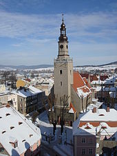
- The town hall, built in the neo-renaissance style, was inaugurated in 1905 and is located at today's Plac Grunwaldzki. A first town hall was mentioned in Landeshut as early as 1564. This burned out in 1638 during the Thirty Years War . It was rebuilt in 1660 and demolished again in 1873. The city then acquired the Conrad'sche Haus in what was then Kirchgasse. On January 29, 1903, the city decided to build a new town hall. The foundation stone was laid on June 23, 1904, the inauguration on November 30, 1905. The Wroclaw architects Richard Gaze and Alfred Böttcher provided the design. The building has been a listed building since June 1977.
- At the Ring (Polish: Rynek ), the Landeshut market square, there are town houses from the 17th to the 19th centuries.
- To the north-east of the Gnadenkirche is the former Protestant middle school for girls from the 2nd quarter of the 18th century and the choir from 1725.
- The rectory dates from the 2nd half of the 18th century.
- Ruins of Kreppelhof Castle , which burned out in 1964.
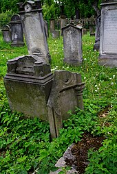
- There are still two Jewish cemeteries in the urban area, which were established in 1824 and 1881.
- The old station building was built in 1869.
Rural community
The rural community of Kamienna Góra covers an area of 158.1 km² with 9019 inhabitants (as of June 30, 2019). The eponymous city of Kamienna Góra is not part of the rural municipality, but forms its own municipality.
sons and daughters of the town
Sorted by year of birth
- Enoch Gläser (1628–1668), lawyer and pastoral poet
- Christian Ludovici (1663–1732), classical philologist and orientalist
- Christian Samuel Ulber (1714–1776), Protestant theologian
- Carl Gotthard Langhans (1732–1808), master builder
- Heinrich Adamy (1812–1897), geographer and teacher
- Gustav Adolph Schlöffel (1828–1849), revolutionary
- Gustav von Schrötter (1830–1919), Prussian lieutenant general
- Carl Jentsch (1833–1917), German theologian, priest, writer and publicist
- Heinrich Oberländer (1834–1911), actor
- Wilhelm von Schroetter (1837–1918), Prussian administrative officer and district administrator of Wittgenstein
- Wilhelm Fries (1845–1928), German philologist and educator
- Julian Prerauer (1848–1934), industrialist
- Moritz Seidel (1853–1926), District Administrator in Silesia, MdHdA
- Hermann von Chappuis (1855–1925), district administrator and ministerial official in Prussia
- Bernhard Nocht (1857–1945), tropical medicine
- Ewald Vogtherr (1859–1923), politician (SPD)
- Johann Modler (1875–1964), inventor and entrepreneur
- Hermann Koenig (1883–1961), landscape architect
- Marie Muthreich (1884–1961), poet and narrator
- Friedrich Iwan (1889–1967), painter and graphic artist
- Walther Arndt (1891–1944), zoologist
- Georg Schubert (1899–1968), sculptor
- Viktor Hamburger (1900–2001), biologist
- Rudolf Hamburger (1903–1980), architect and GRU agent
- Edelhard Rock (1908–1985), printer, publisher and politician (CDU), Member of the Bundestag
- Paul Rudolf Opitz (1910–2010), glider pilot and test pilot
- Kurt Erlebach (1922–2008), politician (KPD)
- Georg Kretschmar (1925–2009), Protestant theologian
- Peter Rummel (1927–2014), Catholic church historian
- Horst Weigelt (1928–2018), railway engineer and author
- Konrad Pätzold (1928–2017), civil engineer
- Joachim Wiesner (1934–2009), political scientist
- Jürgen Rauschenel (1936–2005), business journalist and publisher
- Hartmut Kleineidam (1939–1990), Romanist
- Damian Dąbrowski (* 1992), football player
Say
The Rübezahl legend is set in Landeshut by Master Zwirbel . According to the legend, the Landeshut master tailor Leberecht Zwirbel Rübezahl cheated on two yards of cloth and had to ride a billy goat from the city gate to his house as a punishment. Since then, Zwirbel would have been the most honest tailor in the region.
literature
- Hugo Weczerka (Hrsg.): Handbook of the historical places . Volume: Silesia (= Kröner's pocket edition . Volume 316). Kröner, Stuttgart 1977, ISBN 3-520-31601-3 , pp. 261-264.
- Johann Georg Knie : Alphabetical-statistical-topographical overview of the villages, towns, cities and other places of the royal family. Preusz. Province of Silesia. 2nd Edition. Graß, Barth and Comp., Breslau 1845, pp. 850-851 .
- Dehio Handbook of Art Monuments in Poland Silesia . Munich and Berlin 2005, ISBN 3-422-03109-X , pp. 419-422.
Web links
- Homepage of the city of Kamienna Góra
- Polska na fotografii: Kamienna Góra. In: polska-org.pl. (Polish, historical and current recordings and geographic location).
- Timeline for the history of the Landeshut district. In: landeshut.de. September 17, 2000.
- City state hat in Silesia. In: landeshut.de. June 2, 2000(memorial documents, views, newspaper clippings, etc.).
- State hat working group.
Individual evidence
- ↑ a b population. Size and Structure by Territorial Division. As of June 30, 2019. Główny Urząd Statystyczny (GUS) (PDF files; 0.99 MiB), accessed December 24, 2019 .
- ^ City website, Władze Miasta , accessed on February 20, 2015
- ^ Friedrich Bernau: The brothers of Schönburg and Lichtenburg . In: Schatzlar and its district communities . Marburg / Lahn 1993, p. 99
- ↑ P. Ambrosius Rose: Grüssau Monastery . Stuttgart 1974, ISBN 3-8062-0126-9 , p. 47 and 54
- ↑ a b Meyer's Large Conversation Lexicon . 6th edition, Volume 12, Leipzig / Vienna 1908, p. 101 .
- ↑ Wolfgang Benz , Barbara Distel (ed.): The place of terror . History of the National Socialist Concentration Camps. Verlag CH Beck, Munich (9 volumes; 2005–2009).
- ↑ Isabell Sprenger: Groß-Rosen . A concentration camp in Silesia. Böhlau Verlag, 1997, ISBN 3-412-11396-4 .
- ↑ Alexander August Mützell and Leopold Krug : New topographical-statistical-geographical dictionary of the Prussian state . Volume 3: Kr – O , Halle 1822, p. 60, item 311.
- ↑ Johann Georg Knie : Alphabetical-statistical-topographical overview of the villages, spots, cities and other places of the royal family. Prussia. Province of Silesia, including the Margraviate of Upper Lusatia, which now belongs entirely to the province, and the County of Glatz; together with the attached evidence of the division of the country into the various branches of civil administration. Melcher, Breslau 1830, p. 954 .
- ^ Johann Georg Knie : Alphabetical-statistical-topographical overview of the villages, spots, cities and other places of the royal family. Preusz. Province of Silesia. 2nd Edition. Graß, Barth and Comp., Breslau 1845, p. 850 .
- ^ A b Royal Statistical Bureau: The municipalities and manor districts of the province of Silesia and their population. Based on the original materials of the general census of December 1, 1871. Berlin 1874, pp. 246-247, item 1 .
- ^ A b c d Michael Rademacher: German administrative history from the unification of the empire in 1871 to the reunification in 1990. landeshut.html. (Online material for the dissertation, Osnabrück 2006).
- ↑ http://www.landeshut.de/ortschaften/landeshut/rathaus/rathaus.html
- ↑ http://www.nid.pl/pl/Informacje_ogolne/Zabytki_w_Polsce/rejestr-zabytkow/zestawienia-zabytkow-nieruchomych/DLN-rej.pdf
- ↑ http://www.sztetl.org.pl/pl/article/kamienna-gora/12,cmentarze/4037,cmentarz-zydowski-ul-katowicka-/
- ↑ http://www.sztetl.org.pl/pl/article/kamienna-gora/12,cmentarze/4688,cmentarz-w-kamiennej-gorze-ul-ksiecia-bolka-i/
- ↑ http://dolny-slask.org.pl/528448,Kamienna_Gora,Dworzec_kolejowy_Kamienna_Gora.html
- ^ E. Berger: Rübezahl and other mountain sagas. Bookstore Gustav Fock, page 37 f.


