Kowary
| Kowary | ||
|---|---|---|

|
|
|
| Basic data | ||
| State : | Poland | |
| Voivodeship : | Lower Silesia | |
| Powiat : | Jelenia Gora | |
| Area : | 37.39 km² | |
| Geographic location : | 50 ° 48 ' N , 15 ° 50' E | |
| Height : | 430 m npm | |
| Residents : | 10,869 (Jun. 30, 2019) |
|
| Postal code : | 58-530 | |
| Telephone code : | (+48) 75 | |
| License plate : | DJE | |
| Economy and Transport | ||
| Street : | Jelenia Góra - Wałbrzych | |
| Rail route : | Jelenia Góra – Kamienna Góra | |
| Next international airport : | Wroclaw | |
| Gmina | ||
| Gminatype: | Borough | |
| Residents: | 10,869 (Jun. 30, 2019) |
|
| Community number ( GUS ): | 0206021 | |
| Administration (as of 2014) | ||
| Mayor : | Mirosław Górecki | |
| Address: | ul. 1 Maja 1 A 58-530 Kowary |
|
| Website : | www.kowary.pl | |
Kowary [ kɔˈvarɨ ] ( German Schmiedeberg in the Giant Mountains ) is a town in the powiat Jeleniogórski in the Lower Silesian Voivodeship in Poland . It belongs to the Euroregion Neisse .
Geographical location
The city is located in Lower Silesia at the foot of the Giant Mountains and the Landeshuter Ridge , about 14 kilometers southeast of Jelenia Góra ( Hirschberg ) and 93 kilometers southwest of Wroclaw .
history
Among the Silesian Piasts
Schmiedeberg was first mentioned in a document in 1355 when the region in the border forest in the northern Giant Mountains was cleared by German settlers. At that time it belonged to the Duchy of Schweidnitz , which after the death of Duke Bolko II in 1368 fell to Bohemia under inheritance law , with Bolko's widow Agnes von Habsburg having a usufruct until her death in 1392 . References to an already existing, older settlement in the Schmiedeberg area in connection with ore mining there contain publications by Theodor Eisenmänger from 1900 and by Ephraim Ignatius Naso, who worked as a lawyer and historian in Schweidnitz in the 17th century .
Under the Bohemian and Prussian crown
In 1148 iron ore was found in the area of today's Kowary and mined in 1158 at the behest of the Polish prince Bolesław IV . This is said to have resulted in a small settlement in which the iron ore was processed using iron hammers . In 1241 the miners took part in the battle against the Mongols at Wahlstatt .
On September 4, 1513 Schmiedeberg received by the Czech King Vladislav II. The town charter and the acceptance of the coat of arms. Along with Breslau and Schweidnitz, Schmiedeberg was one of the most important centers of the iron industry in Lower Silesia in the 16th century . Firearms in particular were a sought-after product by local craftsmen. During the Thirty Years' War the city was largely destroyed and the town's heyday ended. Mining came to a standstill as the ore mine was flooded. The weaving trade subsequently developed .
At the beginning of the 20th century Schmiedeberg had a Protestant church, a Catholic church, a preparatory institute , a district court, important production facilities for the textile industry, a printing shop, a lithographic institute, a metalworking industry, including a factory for the manufacture of surgical instruments, magnetic iron pits and granite and marble quarries.
After the First Silesian War in 1742 Schmiedeberg fell together with most of Silesia to Prussia. In the 18th and 19th centuries there were attempts to revive the mining industry.
In 1945 Schmiedeberg belonged to the district of Hirschberg in the Giant Mountains in the administrative district of Liegnitz in the Prussian province of Silesia of the German Empire .
1945 until today
After the end of the Second World War in May 1945 Schmiedeberg had about 4,000 inhabitants. Until then, the population consisted almost exclusively of Germans. Some local townspeople fled west before or during the capture of the town by Red Army troops . In the summer of 1945 Schmiedeberg, like almost all of Silesia, was placed under Polish administration by the Soviet occupying forces . The place name was translated into Polish as Kowary . In the period that followed, the German residents were expelled from Schmiedeberg by the local Polish administrative authorities . The Polish immigrants came mainly from the areas east of the Curzon Line that had fallen to the Soviet Union as part of the " West shift of Poland " .
In addition to the textile industry, uranium ore mining was also important from 1948 to 1972 .
- Population development
| year | Residents | Remarks |
|---|---|---|
| 1840 | 3,635 | of which 2,963 Protestants and 672 Catholics |
| 1900 | 5,675 | mostly evangelicals |
| 1933 | 6,395 | |
| 1939 | 6,644 | |
| 2015 | 11,345 |
Incorporations
The places Krzaczyna ( Busch Vorwerk ) Podgórze ( Arnsberg ) and Voikov ( Hohenwiese ) have been incorporated.
Attractions
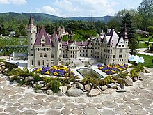
- Miniature park of the architectural monuments of Lower Silesia by Marian Piasecki on the site of the former carpet weaving mill "Smyrna" (1854–2009)
- Old town of Kowary in the former Marktstr. (ul. 1 Maja)
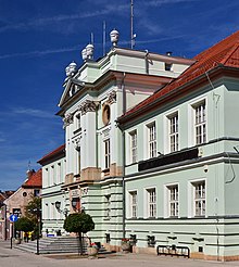
- Classicist town hall, built 1786–1789 by Christian Schultz with the participation of the Landeshut master builder Carl Gotthard Langhans with a vestibule and council chamber
- Late Gothic Catholic parish church of St. Marien on Franziskanerplatz
- Crypt houses in the old cemetery next to the church
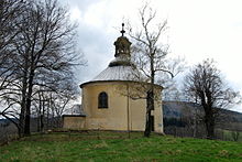
- Chapel of St. Anne in Mittel-Schmiedeberg
- Baroque stone bridge with a statue of the Bohemian national saint John Nepomuk
- City villa (manufacturer's villa of the carpet factory), now Hotel "Smyrna"
- former synagogue , built in the 19th century
- Traditional house of the Heimatverein
- former train station with water tower and old railway crane
- "New settlement" of uranium mining, built 1949–1952, with school and cultural center (now cultural center and library)
- Neuhoff Castle (now: Nowy Dwór ) in the Radociny district, owned by the Princes of Reuss-Köstritz from 1827 to 1945
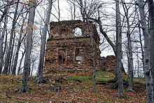
- Ruhberg Castle (today: Ciszyca ) and former landscape park, owned by Prince Anton Radziwiłł until 1831
- “Hohenwiese” sanatorium, built 1900–1902 by the Wroclaw architect Carl Grosser, and “Buchwald” sanatorium (1916–1920) in the Hohenwiese district (Wojków)
- Graves of the Reuss family at Köstritz j. L. in Hohenwiese
- Former mine "Kowarskie Kopalnie" with an underground educational trail and recreation center "Jelenia Struga" (from 1974 to 1989 radon inhalation facility) in the Arnsberg district (Podgórze)
Twin cities
- Jægerspris (Denmark)
- Kamień Pomorski (German Cammin ) (Poland)
- Schönau-Berzdorf (Germany)
- Vrchlabí ( Hohenelbe ) (Czech Republic)
sons and daughters of the town
- Martin Fruwein († 1621), one of the most active participants in the Bohemian uprising of 1618
- Eduard von Peucker (1791–1876), Prussian general, member of the Prussian manor house
- Henry IX. Reuss zu Köstritz (1827–1898), Prussian general
- Carl Hermann Lamprecht (1840–1881), German politician and mayor of Siegen from 1876 to 1881
- Max Heilmann (1869–1956), German graphic artist and painter
- Werner von Rheinbaben (1878–1975), German naval officer, corvette captain, diplomat, a. a. Naval attache , publicist
- Ernst Meister (1887–1939), Prussian state geologist
- Friedrich-August Schack (1892–1968), General of the Infantry, bearer of the Knight's Cross
- Lew Hohmann (* 1944), German filmmaker and film scholar
Say
Schmiedeberg is mentioned in several Rübezahl sagas. Die Sagen Der Wunderstab and Rübezahl performs a concert on play in the place. In the first saga, Rübezahl gives a naturalist a magic wand that can cover great distances in seconds. In the other legend, Rübezahl punishes the Schmiedeberger town musician Knarr. Since Knarr had claimed to bewitch Rübezahl himself with his music, Rübezahl enchanted Knarr and an orchestra in such a way that they turned into monkeys and bears at a big concert and played horribly without Knarr himself being able to perceive it. Knarr claimed that he would never be able to enchant the mountain spirit again.
literature
- Hugo Weczerka (Hrsg.): Handbook of the historical places . Volume: Silesia (= Kröner's pocket edition . Volume 316). 2nd, improved and enlarged edition. Kröner, Stuttgart 2003, ISBN 3-520-31602-1 , p. 476.
Web links
- City website (Polish, German, English)
- "Kowary / Schmiedeberg"
Individual evidence
- ↑ a b population. Size and Structure by Territorial Division. As of June 30, 2019. Główny Urząd Statystyczny (GUS) (PDF files; 0.99 MiB), accessed December 24, 2019 .
- ^ Arne Franke: The Silesian Elysium. 2005, ISBN 3-936168-33-4 , p. 6
- ^ History of the town of Schmiedeberg in the Giant Mountains. Verlag May Woywod, Breslau 1900, p. 1
- ↑ Hermann Margrave: Naso, Ephraim Ignatius . In: Allgemeine Deutsche Biographie (ADB). Volume 23, Duncker & Humblot, Leipzig 1886, p. 261.
- ↑ Homepage Kowary - Geschichte ( Memento of the original from January 6, 2010 in the Internet Archive ) Info: The archive link was automatically inserted and not yet checked. Please check the original and archive link according to the instructions and then remove this notice. (Polish)
- ↑ a b Meyer's Large Conversation Lexicon . 6th edition, Volume 17, Leipzig / Vienna 1909, p. 901.
- ^ Johann G. Knie: Alphabetical-statistical-topographical overview of the villages, spots, cities and other places of the royal family. Preusz. Province of Silesia . 2nd edition, Breslau 1845, pp. 918-919.
- ^ A b Michael Rademacher: German administrative history from the unification of the empire in 1871 to the reunification in 1990. hirschberg.html # ew39hbrgschmd. (Online material for the dissertation, Osnabrück 2006).
- ^ E. Berger, Rübezahl and other mountain sagas , Gustav Fock bookstore, page 25 ff.
- ^ E. Berger, Rübezahl and other mountain sagas , Gustav Fock bookstore, page 112 ff.


