
Landeshuter ridge
| Landeshuter ridge | ||
|---|---|---|
 Landeshuter Kamm - The Skalnik |
||
| Highest peak | Skalnik ( 945 m npm ) | |
| location | Poland | |
| part of | Sudeten | |
|
||
| Coordinates | 50 ° 49 ′ N , 15 ° 54 ′ E | |
| surface | 90 km² | |

The Landeshuter Kamm (Polish: Rudawy Janowickie ) in Poland is the easternmost part of the Western Sudetes and covers an area of around 90 km². It connects to the north-east of the Giant Mountains and goes south over the Schmiedeberger Kamm and Kolbenkamm mountain ridges belonging to the Giant Mountains into the small Rehorn Mountains . To the north are the Bober-Katzbach Mountains and to the east the Waldenburger Bergland .
Names
The German name is derived from the town of Kamienna Góra ( Landeshut i. Silesia ) , located southeast of the mountains , while the Polish name refers to the northern town of Janowice Wielkie ( Jannowitz ) and literally means "Jannowitz Ore Mountains". Numerous place and field names in the Landeshuter Kamm refer to metal deposits . For example, after 1945, uranium was mined in mines near Miedzianka ( Kupferberg ) in the northeast of the massif , as well as in Kowary ( Schmiedeberg ) on its western flank. In past centuries gold , lead , copper and arsenic have been mined here successfully .
geography


The Landeshuter Kamm separates the Hirschberger Tal in the west from the Landeshuter Tal in the east. To the east and north it is surrounded in a large arc by the Bober , which connects Kamienna Góra, Janowice Wielkie and Jelenia Góra ( Hirschberg i. Rsgb. ).
The main ridge of the mountain stretches 16 kilometers in a north-south direction from Janowice Wielkie in the north to the Schmiedeberger Pass (Polish: Przełęcz Kowarska ) (727 m), a mountain pass in the south that forms the border with the Giant Mountains . The Przełęcz Rudawska (pass, 740 m) divides the main ridge into a southern and a northern section. The highest point of the mountain is the Skalnik (945 m) with the rock group of the Friesensteine (Ostra Mała and Konie Apokalipsy) in the southern section, while Dzicza Góra (891 m) and Wołek (878 m) represent the highest points in the north of the massif. Several side ridges branch off to the side, of which the north-western one is the most important. This is separated from the rest of the mountains by the deeply cut Karpnicka Przełęcz (pass, 475 m) and forms the so-called Falkenberge (Polish Sokole Góry). The highest peaks here are the twin mountains Krzyżna Góra ( Kreuzberg ), 654 m, and Sokolik ( Forest Mountain ), 642 m, which form a striking, almost symmetrical double formation that is visible throughout the Hirschberg Valley.
Attractions

In 1989 the Landeshuter Kamm landscape protection park ( Rudawski Park Krajobrazowy ) was created with an area of 88 km². Since then, almost the entire mountain range has been under nature protection .
Especially the north of the mountains and the picturesque Falkenberge have dramatic cliffs and rock formations that are up to 60 meters high. The most famous are Most Skalny ("Rock Bridge"), Skalne Bramy ("Rock Gates ") and Starościńskie Skały ("Marianne Rock "). After the High Tatras , the Landeshuter Kamm is the most popular climbing area in Poland. Furthermore, in the east of the massif, near the village of Wieściszowice ( Rohnau ), there are the Kolorowe Jeziorka ("Colored Lakes") - three lakes that naturally seeped into the old excavation pits Hope , Gustav and New Luck from the 18th century Century. Metal oxides cause your water to shimmer purple, green and azure blue. In the Landeshuter Kamm stands the oldest mining hut in the Sudetes , the Schweizerei (Polish: Szwajcarka ) from 1823. The touristic development is extensive, the network of hiking trails extremely dense. The peaks and passes offer some of the most beautiful views of the Giant Mountains in the southwest and the Waldenburger Bergland in the east.
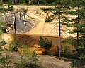
The purple lake, Purpurowe Jeziorko

The azure lake, Błękitne Jeziorko
The green lake, Zielone Jeziorko


Another attraction is the Stary Trakt Kamiennogórski , an old, boldly laid out country road over the Przełęcz pod Bobrzakiem (pass, 805 m) in the southern main ridge, which is closed to motor vehicle traffic , which was built in 1778 and has been preserved in its historical state to this day. The stagecoaches once drove here from Wroclaw via Schweidnitz ( Świdnica ) to Hirschberg ( Jelenia Góra ). The most famous village on the Landeshuter Kamm is Karpniki ( Fischbach ) on the south-west flank of the Falkenberge, where a castle (former summer residence of the Prussian Prince Wilhelm of Prussia ) is located. Nearby is Bukowiec ( Buchwald ), once the seat of the von Reden family , with an idyllic landscape park and Kowary ( Schmiedeberg ) with the sanatoriums in Hohenwiese (Wojków).
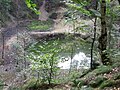
Mountains and rock formations
The Grzbietowa Droga (Kammweg) leads over the Landeshuter Kamm, in the northern section with blue marking, in the southern section with yellow marking.
| Mountains / rock formations | height | location | image | |
|---|---|---|---|---|
| mountains | ||||
| Bielec - Röhrberg | 871 m |
(Location) |
|
|
| Bobrzak - Beaver's Mountain, in the southern part of the ridge | 839 m |
(Location) |
|
|
| Dzicza Góra - Sauberg | 881 m |
(Location) |

|
|
| Jańska Góra - Hennings Mountain | 865 m |
(Location) |
|
|
| Kowarska Czuba (or Chubatka) - Spitzberg, in the southern part of the ridge | 731 m |
(Location) |
|
|
| Mały Wołek - Little Ox Head | 774 m |
(Location) |
|
|
| Ostra Mała - Free Koppe | 935 m |
(Location) |

|
|
| Rudnik - Leuschner Berg, in the southern part of the ridge | 853 m |
(Location) |
|
|
| Siodlak - Sattelberg, in the southern part of the ridge | 610 m |
(Location) |
|
|
| Skalica - rock mountain | 748 m |
(Location) |
|
|
| Skalnik | 945 m |
(Location) |
|
|
| Sucha Góra - Drought Mountain | 595 m |
(Location) |
|
|
| Świnia Góra - Saukamm | 751 m |
(Location) |

|
|
| Wilczysko - Wolfsberg |
(Location) |
|
||
| Wołek - ox head | 878 m |
(Location) |
|
|
| Rock formations | ||||
| Czartówka (Devil's Rock) | 670 m |
(Location) |

|
|
| Diabelski Kościół - Devil's Church | 620 m |
(Location) |

|
|
| Fajka (pipe) | 530 m |
(Location) |

|
|
| Gąsienica (caterpillar) |
(Location) |

|
||
| Głaziska Janowickie - Jannowitz Rock |
(Location) |

|
||
| Kazalnica (pulpit) |
(Location) |

|
||
| Konie Apokalipsy - frieze stones | 930 m |
(Location) |

|
|
| Krowiarki - cow cellar |
(Location) |

|
||
| Malinowa (raspberry) |
(Location) |

|
||
| Miedziane Skaly - Kupferberger stones | 721 m |
(Location) |

|
|
| Orzech (nut) |
(Location) |

|
||
| Owczarek - Schäferstein, in the southern part of the ridge |
(Location) |
|
||
| Piec - oven stone or Friedrich-Wilhelm-Stein, named after Prince Wilhelm of Prussia | 570 m |
(Location) |

|
|
| Pieklisko (hell or forge) | 650 m |
(Location) |

|
|
| Poziomkowa (strawberry) |
(Location) |

|
||
| Rylec (needle) |
(Location) |

|
||
| Skalne Bramy - Gate Cliff | 620 m |
(Location) |

|
|
| Skalny Most (rock bridge) | 590 m |
(Location) |

|
|
| Skały Ścianki - Mint Stone | 550 m |
(Location) |

|
|
| Starościńskie Skały with Lwia Góra (Lion Mountain) | 718 m |
(Location) |

|
|
| - with Starościańska Igła (Mayor's Needle) |
(Location) |

|
||
| - with Starościańska Skała - Mariannenfels, named after Princess Marianne of Prussia |
(Location) |

|
||
| Strużnickie Skały (Strużnica or Neudorf rocks) |
(Location) |

|
||
Web links
- www.sudety.wroclaw.pl/index/gory/regiony/ID,14 - Landeshuter Kamm: information, description and pictures (Polish)
- Landeshuter Kamm (Polish: Rudawy Janowickie)
Individual evidence
- ↑ Mes table sheet No. 5161, Kupferberg (accessed on July 29, 2016)