
Derbyshire
| Derbyshire county | ||
|---|---|---|
|
||
|
|
||
 .svg) |
||
|
|
||
| Country | United Kingdom | |
| Part of the country | England | |
| region | East Midlands | |
|
|
||
| status | Ceremonial and Administrative County | |
| First mention | 1048 | |
|
|
||
| Ceremonial county | ||
| surface | 2,625 km² | |
| Residents | 1,053,316 | |
| was standing | June 30, 2018 | |
|
|
||
| Administrative county | ||
| Administrative headquarters | Matlock | |
| ISO-3166-2 | GB-DBY | |
| surface | 2,547 km² | |
| Residents | 796.142 | |
| was standing | June 30, 2018 | |
| ONS code | 17th | |
| GSS code | E10000007 | |
| NUTS code | UKF12, UKF13 | |
| Website | www.derbyshire.gov.uk | |
|
|
||
Districts / Unitary Authorities
|
||

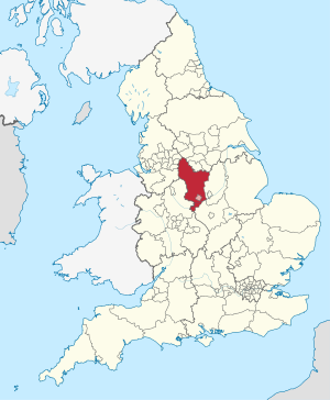
Derbyshire [ ˈdɑːbɪʃə ] is a county in the East Midlands of England .
geography

The county is located in a mountainous landscape. Most of the Peak District National Park is within Derbyshire. The northern part of the county overlaps with the Pennines , a famous range of hills and mountains. The county is part of the National Forest and borders the counties and areas of Greater Manchester , West Yorkshire , South Yorkshire , Nottinghamshire , Leicestershire , Staffordshire and Cheshire .
In addition to the County Council in Matlock, there are eight District Councils in the individual counties. Despite the urbanization in 13 cities with between 10,000 and 100,000 inhabitants, large parts of the area are rural: 75% of the population inhabit 25% of the area of the country.
The city of Derby was part of the county until 1998, but is now an autonomous urban district ( Unitary Authority ).
Cities and towns
- Alfreton , Alton , Ashbourne , Ashford-in-the-Water
- Bakewell , Bamford , Baslow , Beeley , Belper , Birch Vale , Bolehill , Bolsover , Borrowash , Bretby , Brimington , Burbage , Burnaston , Buxton , Brough and Shatton
- Castleton , Chapel-en-le-Frith , Charlesworth , Chelmorton , Chesterfield , Clay Cross , Clowne , Cressbrook , Creswell , Cromford , Crowden , Curbar
- Derby , Dronfield , Duffield
- Earl Sterndale , Eckington , Edale , Edensor , Eyam
- Fernilee
- Gamesley , Glossop , Great Hucklow
- Hadfield , Hartington , Hathersage , Hayfield , Heage , Heanor , Hilton , Hope
- Ilkeston
- Little Hucklow , Long Eaton
- Marston Montgomery , Marston on Dove , Matlock , Melbourne , Miller's Dale , Morley
- New Mills , Newhaven
- Over Haddon
- Peak Forest
- Repton , Riber , Ripley
- Shipley , Shirebrook , Staveley , Stoney Middleton , Stretton , Sudbury , Swadlincote
- Tansley , Taxal , Thornhill , Tibshelf , Tideswell , Tunstead Milton
- Walton , Wardlow , Whaley Bridge , Whitwell , Wirksworth
- Youlgreave
Attractions
- Alfreton Hall
- Alsop Hall
- Arbor Low Henge - managed by English Heritage
- Barlborough Hall
- Calke Abbey mansion
- Chatsworth House
- Crich Tramway Village - National Tramway Museum
- Derwent Valley Mills - World Heritage Site
- Haddon Hall Castle
- Hardwick Hall Castle
- Hob Hurst's House - managed by English Heritage
- Howden Reservoir , Derwent Reservoir , Carsington Reservoir , Ladybower Reservoir
- Rock carving from Ladybower Tor
- Mam Tor
- National Stone Center in Wirksworth
- Nine Ladies Stone Circle - managed by English Heritage
- Peveril Castle
- Riber Castle
- Crooked Spire in Chesterfield
- Speedwell Cavern - Speedwell Cavern
- Stanage Edge - steep terrain with the longest climbing route in Great Britain
- Sutton Scarsdale Hall - managed by English Heritage
- Wingfield Manor - managed by English Heritage
Others
The World Toe Wrestling Championship has been held in Derbyshire every year since the 1970s .
Web links
Individual evidence
- ^ A b Mid 2018 Estimates of the population for the UK, England and Wales, Scotland and Northern Ireland
- ^ Off the socks: World Toe Wrestling Championship , on faz.net, June 19, 2015. Accessed May 27, 2019.
Bedfordshire | Berkshire | Buckinghamshire | Cambridgeshire | Cheshire | Cornwall | Cumberland | Derbyshire | Devon | Dorset | Durham | Essex | Gloucestershire | Hampshire | Herefordshire | Hertfordshire | Huntingdonshire | Kent | Lancashire | Leicestershire | Lincolnshire | Middlesex | Norfolk | Northamptonshire | Northumberland | Nottinghamshire | Oxfordshire | Rutland | Shropshire | Somerset | Staffordshire | Suffolk | Surrey | Sussex | Warwickshire | Westmorland | Wiltshire | Worcestershire | Yorkshire
Two-tiered counties of England (Non-Metropolitan Counties)
Cambridgeshire |
Cumbria |
Derbyshire |
Devon |
East Sussex |
Essex |
Gloucestershire |
Hampshire |
Hertfordshire |
Kent |
Lancashire |
Leicestershire |
Lincolnshire |
Norfolk |
Northamptonshire |
North Yorkshire |
Nottinghamshire |
Oxfordshire |
Somerset |
Staffordshire |
Suffolk |
Surrey |
Warwickshire |
West Sussex |
Worcestershire
Unitary Authorities
with County Status
Bath and North East Somerset |
Bedford |
Blackburn with Darwen |
Blackpool |
Bournemouth, Christchurch and Poole |
Brighton and Hove |
Bristol |
Buckinghamshire |
Central Bedfordshire |
Cheshire East |
Cheshire West and Chester |
Cornwall |
County Durham |
Darlington |
Derby |
Dorset |
East Riding of Yorkshire |
Halton |
Hartlepool |
Herefordshire |
Isle of Wight |
Kingston upon Hull |
Leicester |
Luton |
Medway |
Middlesbrough |
Milton Keynes |
North East Lincolnshire |
North Lincolnshire |
North Somerset |
Northumberland |
Nottingham |
Peterborough |
Plymouth |
Portsmouth |
Redcar and Cleveland |
Rutland |
Shropshire |
Southampton |
Southend-on-Sea |
South Gloucestershire |
Stockton-on-Tees |
Stoke-on-Trent |
Swindon |
Telford and Wrekin |
Thurrock |
Torbay |
Warrington |
Wiltshire |
York
with no county status
Bracknell Forest |
Reading |
Slough |
West Berkshire |
Windsor and Maidenhead |
Wokingham
sui generis , with no county status
Isles of Scilly
Bedfordshire | Berkshire | Bristol | Buckinghamshire | Cambridgeshire | Cheshire | City of London | Cornwall | Cumbria | Derbyshire | Devon | Dorset | Durham | East Riding of Yorkshire | East Sussex | Essex | Gloucestershire | Greater London | Greater Manchester | Hampshire | Herefordshire | Hertfordshire | Isle of Wight | Kent | Lancashire | Leicestershire | Lincolnshire | Merseyside | Norfolk | North Yorkshire | Northamptonshire | Northumberland | Nottinghamshire | Oxfordshire | Rutland | Shropshire | Somerset | South Yorkshire | Staffordshire | Suffolk | Surrey | Tyne and Wear | Warwickshire | West Midlands | West Sussex | West Yorkshire | Wiltshire | Worcestershire
Coordinates: 53 ° 8 ′ N , 1 ° 34 ′ W