Derbyshire Dales
| Derbyshire Dales District | |
|---|---|
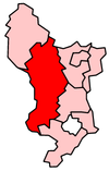
 Location in Derbyshire |
|
| status | District |
| region | East Midlands |
| Administration County | Derbyshire |
| Administrative headquarters | Matlock |
| surface | 795.36 km² (46.) |
| Residents | 70,200 (316.) |
| ONS code | 17UF |
| Website | www.derbyshiredales.gov.uk |
Derbyshire Dales is a district in the county of Derbyshire in England . The largest part is in the Peak District National Park , the population lives mainly along the Derwent River . The administrative seat is the city of Matlock ; other important places are Ashbourne , Bakewell , Baslow , Darley Dale , Eyam , Hathersage , Tideswell and Wirksworth .
The district was formed on April 1, 1974 and arose from the merger of the urban districts Ashbourne, Bakewell, Matlock and Wirksworth and the rural districts Ashbourne and Bakewell. The name was initially West Derbyshire, but was later changed to Derbyshire Dales.
Coordinates: 53 ° 3 ′ N , 1 ° 42 ′ W