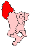
High peak
| Borough of High Peak | |
|---|---|
 Location in Derbyshire |
|
| status | Borough |
| region | East Midlands |
| Administration County | Derbyshire |
| Administrative headquarters | Chapel-en-le-Frith |
| surface | 540.25 km² (92.) |
| Residents | 92,800 (247.) |
| ONS code | 17UH |
| Website | www.highpeak.gov.uk |
High Peak is an administrative district with borough status in the county of Derbyshire in England . The administrative seat is the city of Chapel-en-le-Frith ; other significant places are Buxton , Furness Vale , Glossop , Horwich , New Mills , Tintwistle , Brough and Shatton and Whaley Bridge .
The district was formed on April 1, 1974 and was created from the merger of the Municipal Borough of Buxton and the Urban Districts New Mills and Whaley Bridge. The Tintwistle Rural District was added by the county of Cheshire .
Coordinates: 53 ° 21 ′ N , 1 ° 51 ′ W