
Whaley Bridge
| Whaley Bridge | |||
|---|---|---|---|
| Coordinates | 53 ° 20 ′ N , 1 ° 59 ′ W | ||
|
|||
| Residents | 6455 (2011 census) | ||
| administration | |||
| Part of the country | England | ||
| region | East Midlands | ||
| Shire county | Derbyshire | ||
| District | High peak | ||

Whaley Bridge is a small town in the High Peak District in Derbyshire in England. It is located about 16 miles southeast of Manchester , 11 kilometers north of Buxton , 14 kilometers east of Macclesfield and 45 kilometers west of Sheffield . In the 2011 census, the city including Furness Vale, Horwich End, Bridgemont, Fernilee, Stoneheads and Taxal had 6455 inhabitants. The city lies on the River Goyt .
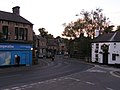
Whaley Bridge (2005)
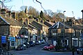
Whaley Bridge (2010)
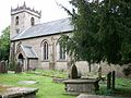
St. James (2010)

Canal (2004)


Individual evidence
- ^ Whaley Bridge Parish - Local Area Report , accessed August 9, 2019
Web links
Commons : Whaley Bridge - collection of pictures, videos and audio files