
Peak District National Park
| Peak District National Park | |||
|---|---|---|---|
 |
|||
|
|||
| Location: | England , UK | ||
| Surface: | 1404 km² | ||
| Founding: | April 17, 1951 | ||
| Address: | Official website of the national park | ||

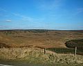
The Peak District National Park (English Peak District National Park ) is a national park in northern England . The park was designated in 1951 and has an area of 1404 km². The park is divided into two natural spatial elements: the Dark Peak , which includes most of the uninhabited raised bogs , and the southern White Peak , in which most of the settlement areas can be found. The Dark Peak is part of the counties of Greater Manchester and Yorkshire , while the White Peak area of Staffordshire , Derbyshire and Cheshire covers. The White Peak consists largely of grasslands that are used for breeding sheep. Dry river beds and caves (e.g. the Peak Cavern at Castleton in Derbyshire) can also be found. From 1940 to 2009 there was a population of wild red-necked wallabies in the Peak District that was introduced from Tasmania .
tourism
The national park is a protected territory and is 1404 km² in size. The Peak District is largely private land and has not always been accessible to hikers and nature lovers. In 1932 there was a protest ( Mass trespass of Kinder Scout ) when around 400 people crossed the Kinder Scout moorland without permission , thereby changing the law. In 1935 the Pennine Way was created , England's longest hiking trail, which runs north-south through the Peak District and stretches for 431 kilometers from Edale to Kirk Yetholm on the Scottish border. The trail was created at the suggestion of British journalist Tom Stephenson, who was inspired by similar trails in the USA.
On April 17, 1951, the Peak District in England was the first area to be declared a national park and largely opened up for the population. In September 2004, additional areas in the east and northeast of the Peak District were opened to the public. The national park is used for a variety of recreational activities such as hiking , horse riding , climbing , cycling and air sports.
Renaturation

In September 2013, the National Trust , which owns large areas in the national parks, published a plan to renaturate bogs in the Peak District; especially the plateaus are to be worked up. They want the water level to rise again by filling in drains, but also certain plants such as grasses should be replanted on the surfaces and the erosion damage removed. It is expected that it will take around 50 years before the measure is completed and the original landscape appears again.
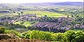
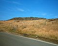
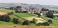
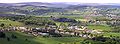
Views of the Peak District
Burbage Rocks
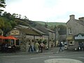
Castleton
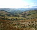
Dale Bottom - Hathersage

Dunford Bridge
Hepworth
Higger Gate

Holmfirth
Holme, West Yorkshire

Holme Moss Radio Tower

Scholes

The Rising Sun

Toad's Mouth
Totties

Upper Holme Valley


.jpg)
.JPG)

.JPG)


Web links
Individual evidence
- ↑ Michael McCarthy: The decline and fall of the Peak District wallabies In: The Independent of February 20, 2013
- ↑ www.peakdistrict.gov.uk: Fact Sheet I: The Peak District National Park ( Memento of the original from January 21, 2012 in the Internet Archive ) Info: The archive link was inserted automatically and has not yet been checked. Please check the original and archive link according to the instructions and then remove this notice. (English), accessed on December 27, 2011
- ↑ Peak District's High Peak Moors to see 50-year restoration plan on BBC News September 20, 2013, accessed September 20, 2013.