
Yorkshire Dales


As Yorkshire Dales , locally the Dales , the river valleys in the central part of the Pennines mountain range in northern England are summarized. Together with the ridges between them, they form a rural, sparsely populated region in the northern English counties of North Yorkshire , West Yorkshire and Cumbria . The Yorkshire Dales in the strict sense are the valleys north of the River Wharfe .
Surname
The Dales get their name from the Danish word dale (= valley).
Most of the Dales are named after the river flowing through it (Swale → Swaledale) or vice versa (Deepdale → Deepdale Beck). The best- known exception is Wensleydale , which is named after the village of Wensley and is traversed by the River Ure .
geography
The dales are 'U' or 'V' shaped valleys, formed by glaciers especially from the most recent glacial period . The mountains consist for the most part of limestone types and show pronounced karst forms such as caves, gorges, river subsidence (the best known is Gaping Gill ) and extensive, furrowed rock surfaces.
The Dales area is cut by the main watershed of England, which corresponds to the ridge of the Pennines. Most of the Dales drain east to the North Sea , some west to the Irish Sea .
The landscape of the Dales is characterized by cattle pastures separated by dry stone walls . They provide nutritious grass and are mainly found in the valleys, while in the higher areas a type of vegetation known as moorland predominates: barren land overgrown with fern, hard grass and heather , in which numerous wild animals such as the red grouse find habitat, but also sheep become.

A small road through the “wild” moorland leads to the cultivated land further back.
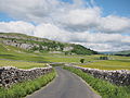
Road through Littondale
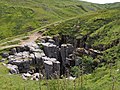
Karst processes formed bizarre rifts between Swaledale and Wensleydale .

At Gunnerside Beck, a Swale tributary, lead ore was mined in open-cast mining ; the wide, bare scree fields are still there.
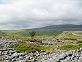
An extensive limestone plateau west of Ribblesdale. What looks like a scree field is actually a continuous rock.

Raised bog in the moorlands at the end of October, with Swale- and Arkengarthdale in the background.

Thornton Force, a 14 meter high waterfall on the Twiss River. The falls can be seen from the Ingleton Waterfalls Trail.


history
Finds in numerous caves indicate prehistoric settlement in the Yorkshire Dales. Agriculture was also practiced in the Bronze Age . The Romans used some lead mines and built high-altitude trails through the Pennines .
Danish Vikings later left their linguistic legacy behind. For example, the word “ dale ” (originally “ dalr ”) goes back to the Vikings. In the Middle Ages, monastic orders gained influence and built numerous abbeys. They also established wool production. The demand for natural stone and marble led to an economic boom.
In the 17th and 18th centuries the region experienced a brief boom through lead ore mining in Swaledale, Arkengarthdale and Pateley Bridge. There was also a textile boom. Many huts set up their own looms and the whole family was involved in textile production. When modern industrial plants replaced this traditional method of production, many families emigrated, so that today only about 18,000 people live in the entire area.
tourism
The Yorkshire Dales are crossed by several long distance footpaths : Pennine Way , Coast to Coast Walk , Dales Way and Pennine Bridleway .
Numerous local hiking and biking trails are available for short trips. The Herriot Way leads through Wensleydale and Swaledale in the footsteps of the TV series The Doctor and the Dear Cattle . The Three Peaks Walk is a special challenge for mountain hikers.
National park


In 1954, the Yorkshire Dales National Park was established on an area of 1,765 km² . Most of this national park is in North Yorkshire . In 2016 the park was expanded by around 260 km² or 24% of its old area. It now includes parts of the upper reaches of the River Lune , which lie in Cumbria and Lancashire . Areas northeast of Kirkby Lonsdale with the Leck Fell , the highest point in Lancashire, were included in the national park.
The national park does not include all of the Yorkshire Dales. For example, Nidderdale does not belong to it, but has been under a similar protection status as the AONB since 1994 .
The number of visitors is more than eight million each year.
Cultural references
In the Yorkshire Dales, the stories of the veterinarian and writer James Herriot take place , which also served as a template for the TV series The Doctor and the Dear Cattle . Almost all of the outdoor scenes in the TV series were actually shot in the Yorkshire Dales.
The American travel writer Bill Bryson lived in the Yorkshire Dales for a while and described them in his book Notes from a Small Island . Charlotte Link's novel "The Sisters' House" is also set in the Dales. This is how the Wensleydale is mentioned.
The TV series Shaun the Sheep is set in a characteristic Yorkshire landscape.
List of Dales
Side valleys are marked by arrows ↑ on their "Muttertal". Example: Cragdale joins Raydale, which in turn joins Wensleydale.
East side, draining to the North Sea, from north to south
| Surname | flow | Localities | ||
|---|---|---|---|---|
| Teesdale | River teas | Barnard Castle, Mickleton, Middleton-in-Teesdale | ||
| ↑ | Deepdale | Deepdale Beck | ||
| ↑ | Baldersdale | River Balder | Baldersdale | |
| ↑ | Lunedale | River Lune | Grass spars | |
| Swaledale | River Swale | Reeth, Gunnerside, Muker | ||
| ↑ | Arkengarthdale | Arkle Beck | Langthwaite | |
| ↑ | East Stonesdale | East Gill | ||
| ↑ | West Stonesdale | Stonesdale Beck | ||
| ↑ | Whitsundale | Whitsundale Beck | ||
| ↑ | Great Sled Dale | Great Sleddale Beck | ||
| ↑ | Birkdale | Birkdale Beck | ||
| Wensleydale | River Ure | Leyburn, Wensley, Askrigg, Hawes | ||
| ↑ | Colsterdale | River Burn | Colsterdale | |
| ↑ | Coverdale | River cover | Coverham, Carlton, Horsehouse | |
| ↑ | Apedale | Apedale Beck | Redmire | |
| ↑ | Bishopdale | Bishopdale Beck | Thoralby | |
| ↑ | Walden Dale | Walden Beck | West Burton | |
| ↑ | Raydale | Raydale Beck / River Bain | Bainbridge, Countersett | |
| ↑ | Cragdale | Cragdale Water | Stalling Busk | |
| ↑ | Bardale | Bardale Beck | Marsett | |
| ↑ | Sleddale | Duerley Beck / Gayle Beck | Gayle | |
| ↑ | Fossdale | Hardraw Beck | Hardraw | |
| ↑ | Widdale | Widdale Beck | ||
| ↑ | Cotterdale | Cotterdale Beck | ||
| Nidderdale | River Nidd | Pateley Bridge, Lofthouse, Middlesmoor | ||
| Wharfedale | River Wharfe | Otley, Ilkley, Threshfield, Kettlewell | ||
| ↑ | Washburndale | Washburn | Blubberhouses | |
| ↑ | Mossdale | Mossdale Beck | ||
| ↑ | Littondale | River Skirfare | Arncliffe, Litton | |
| ↑ | Langstrothdale | River Wharfe (upper reaches) | Yockenthwaite | |
| Airedale | River Aire | Keighley, Skipton | ||
| ↑ | Malhamdale | River Aire (upper reaches) | Malham | |
West side, draining to the Irish Sea, from north to south
| Surname | flow | Localities | ||
|---|---|---|---|---|
| Uldale | River Rawthey (upper course) | |||
| Garsdale | Clough River | Garsdale Station | ||
| ↑ | Grisedale | Grisedale Beck | ||
| Dentdale | River Dee | Gawthrop, Cowside At the top is England's highest train station, Dent Station |
||
| ↑ | Deepdale | Deepdale Beck | ||
| Barbondale | Barbon Beck | Barbon | ||
| Lonsdale | River Greta | Burton-in-Lonsdale, Ingleton | ||
| ↑ | Kingsdale | Kingsdale Beck | ||
| ↑ | Twisleton Dale | River Doe | ||
| Crummackdale | Austwick Beck (upper course) | |||
| Ribblesdale | River Ribble | Settle, Horton-in-Ribblesdale | ||
| ↑ | Silverdale | |||
Attractions

- Aysgarth waterfall
- Bolton Castle
- Clapham, Yorkshire
- Cautley Spout waterfall
- Gaping gill
- Grassington
- Hardraw Force
- Hawes
- Horton in Ribblesdale
- Kisdon Force waterfall, Swaledale
- Malham
- Reeth
- Sedbergh
- Settle
- Yockenthwaite Stone Circle
- Yorkshire Three Peaks
Web links
- Yorkshire Dales National Park Authority
- Daelnet - Website of the Yorkshire Dales
- Yorkshire Dales on YorkshireNet
- Yorkshire Dales site
- Photos of the Yorkshire Dales
Individual evidence
- ↑ http://www.yorkshire-dales.com/geology.html , accessed November 16, 2013
- ↑ Helen Pidd, Yorkshire Dales expand into Lancashire in national parks land grab , in: The Guardian, August 1, 2016, accessed August 20, 2016
- ↑ http://www.dentstation.co.uk/ , accessed March 25, 2014
Coordinates: 54 ° 16 ′ N , 2 ° 5 ′ W