
River Ure
| River Ure | ||
 Location of the River Ure in Northern England |
||
| Data | ||
| location | North Yorkshire , England | |
| River system | Humber | |
| Drain over | Ouse → Humber → North Sea | |
| source | Ure Head 54 ° 22 ′ 0 ″ N , 2 ° 18 ′ 0 ″ W. |
|
| Source height | 640 m ASL | |
| End by name change | Crossing into River Ouse Coordinates: 54 ° 2 ′ 4 " N , 1 ° 16 ′ 30" W 54 ° 2 ′ 4 " N , 1 ° 16 ′ 30" W |
|
| Mouth height | 10 m ASL | |
| Height difference | 630 m | |
| Bottom slope | 5.3 ‰ | |
| length | 119 km | |
| Left tributaries | River Swale | |
| Right tributaries | River Bain | |
| Small towns | Hawes , Ripon | |
| Communities | Middleham , Masham , Boroughbridge | |
| Navigable | partially | |
.jpg) Aysgarth Falls in Wensleydale |
||
The River Ure is a river in North Yorkshire , England . It is about 119 km long and ends where it merges into the River Ouse . The Ure is the main river of the Wensleydale , one of the few Yorkshire Dales not named after its river. In the past, however, the valley was also called Yoredale .
The Ure is one of the many waterways that drain the Yorkshire Dales towards the River Ouse. Its main tributaries include the River Swale from the northern neighboring valley and the River Skell .
Surname
The oldest recorded name of the river is Earp , mentioned around the year 1025. This may be a misspelling of Ear Ƿ , where Ƿ stands for the Old English letter Wen or 'w', which means wæter ("water"). From 1140 the river name appears as Jor , from which the name Jervaulx Abbey is derived ("Abbey in the valley of the Jor"), and shortly afterwards as Yore . The current name was first used in the Tudor period by the antiquarians John Leland and William Camden .
The name probably means "strong or nimble river" if one assumes that the Britannic name of the river was Isurā (this is what the Roman name Isurium for Aldborough indicates) and then the intervowel s was omitted, which happened early in British. This explanation establishes a connection between the river name and the Indo-European root is- , which means “strong” and can be found in river names such as the Isar or the Isère .
course
The source of the Ure is at Ure Head in the Abbotside Common highlands . It first flows for 2 km in a south-westerly direction and then follows a bend in the valley to the south-east until it reaches the A684 road and follows it approximately eastwards through the Wensleydale. In the middle of this section are the Aysgarth Falls , a popular waterfall series. At the exit of the valley the Ure turns again to the southeast, passes Jervaulx Abbey and arrives at Boroughbridge , where it is crossed by the A1 .
East of Boroughbridge it takes up the River Swale, which has so far flowed roughly parallel to the north. About 10 km below this confluence, at Cuddy Shaw Reach near Linton-on-Ouse , the Ure merges into the River Ouse.
Level readings
| Level station | Height of the station | Low water * | Flood * | Maximum historically documented flood |
|---|---|---|---|---|
| Bainbridge | 208 m ASL | 0.06 m | 2.5 m | 3.66 m |
| Kilgram | 94 m ASL | 0.27 m | 1.5 m | 5.64 m |
| Masham | 76 m ASL | 0.14 m | 2.3 m | 3.53 m |
| Ripon Ure Bank | 24 m ASL | 0.03 m | 0.89 m | 3.86 m |
| Westwick Lock | 22 m ASL | 0.11 m | 2.5 m | 3.35 m |
| Boroughbridge | 15 m ASL | 9.62 m | 13 m | 15.59 m |
- Low and high tide are average values.
shipping
The Ure is navigable up to the mouth of the Ripon Canal, a good 3 km southeast of the city of Ripon , which results in a navigable river length of almost 22 km. Two short canals, each cutting a bend in the river and bypassing a weir , are navigated by lock : Milby Cut in Boroughbridge and Westwick Cut a few kilometers upstream.
In January 1769, the waterway to the mouth of the River Swale at Swale Nab was first opened as part of the navigation on the River Ouse. In January 1772 the navigability was extended to the Ripon Canal.
In January 1846, the shipping facilities were bought by the Leeds and Thirsk Railway . The maintenance of the waterway was neglected, with the result that the fairway flattened and the barges could no longer be fully loaded. Shipping experienced a small boom in 1860, but its importance continued to decline afterwards. In 1892 there was no shipping traffic beyond Boroughbridge - the North Eastern Railway worked specifically to leave the river above Boroughbridge unused.
Until 1999, the Linton Lock Navigation Commissioners were responsible for shipping to Swale Nab. However, they did not have sufficient funds to maintain the waterway. In 1999 responsibility was transferred to British Waterways . The authority responsible for the waterway is now the Canal & River Trust .
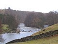
Pictures along the course of the river

The river near the source

West of Hawes

The river at Worton Bridge
River Ure near Aysgarth with Batt Island

Hackfall Gorge at Mickley

At West Tanfield
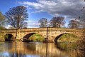
Bridge over the Ure near Ripon

River Ure, Roecliffe

B6265, Hewick Bridge

River Ure as seen from Arrows Bridge


Individual evidence
- ↑ a b A.H. Smith : The Place-names of the West Riding of Yorkshire , Volume 7. Cambridge University Press, 1962, pp. 140-141.
- ^ Wensleydale, Ella Pontefract, JM Dent & Sons, London, 1936
- ^ Entry Ure in: The Cambridge Dictionary of English Place-Names , Ed. Victor Watts, Cambridge University Press, 2010, ISBN 978-0-521-16855-7
- ↑ River Levels . Retrieved December 29, 2010.
- ^ River Ouse (Yorkshire). History . Jim Shead's Waterways Information. Retrieved September 12, 2014.
- ^ River Ure. History . Jim Shead's Waterways Information. Retrieved September 12, 2014.
- ^ A b Charles Hadfield: The Canals of Yorkshire and North East England (Vol 2) . David and Charles, 1973, ISBN 0-7153-5975-4 , pp. 450-452.
- ^ The Gazette, June 18, 1999