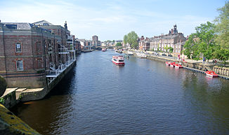
River Ouse (The Humber)
| River Ouse | ||
|
The Ouse in York |
||
| Data | ||
| location | Yorkshire , England | |
| River system | Humber | |
| Drain over | Humber → North Sea | |
| Start as Ouse | at the end of the upper course called Ure 54 ° 2 ′ 4 ″ N , 1 ° 16 ′ 30 ″ W |
|
| Source height | (Name change) 10 m | |
| Estuary (shared with the River Trent ) | in the Humber Estuary coordinates: 53 ° 42 ′ 1 " N , 0 ° 41 ′ 28" W 53 ° 42 ′ 1 " N , 0 ° 41 ′ 28" W. |
|
| Mouth height | 0 m | |
| Height difference | 10 m | |
| Bottom slope | 0.13 ‰ | |
| length | 79 km | |
| Catchment area | 3315 km² | |
| Outflow at the Skelton gauge |
MQ |
44 m³ / s |
| Right tributaries | Wharfe , Aire , Sheaf | |
The River Ouse [ uːz ] (derived from the Celtic word for "water") is a river in Yorkshire , England .
The name of the river Ure changes about 9 kilometers below the confluence of the River Swale in Ouse (near Linton-on-Ouse , 20 kilometers northwest of York ). The Ouse then flows in alternating south to east directions, first through York, later passes Selby and Goole and flows together with the River Trent into the Humber estuary, which is open to the North Sea . Important tributaries are the River Foss , River Wharfe , River Aire , River Derwent and River Don , whose catchments are mainly in the North York Moors and the Yorkshire Dales . Together with its upper course, the Ure, the river has a length of 208 kilometers. (The flow path over the Swale is 183 kilometers long.)
See also
Web links
swell
- ↑ Center for Ecology & Hydrology: Ouse Statistics , National River Flow Archives (accessed November 23, 2013)
- ^ W. Vandenbruwaene, Y. Plancke, T. Verwaest, F. Mostaert: Interestuarine comparison: Hydro-geomorphology , Hydro- and geomorphodynamics of the TIDE estuaries Scheldt, Elbe, Weser and Humber. Version 4. WL reports, 770_62b. Flanders Hydraulics Research: Antwerp 2013 (accessed on November 23, 2013, pdf, English)
