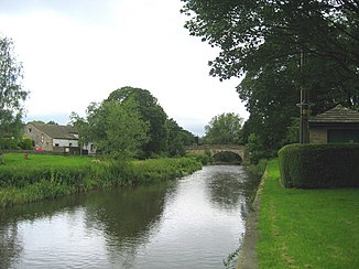
River Aire
| River Aire | ||
|
The Aire at Gargrave , North Yorkshire |
||
| Data | ||
| location | United Kingdom | |
| River system | Humber | |
| Drain over | Ouse → Humber → North Sea | |
| source |
Malham Tarn at Malham 54 ° 3 ′ 19 ″ N , 2 ° 9 ′ 0 ″ W |
|
| Source height | 377 m ASL | |
| muzzle |
Ouse near Airmyn (Great Britain) Coordinates: 53 ° 43 ′ 36 " N , 0 ° 54 ′ 23" W 53 ° 43 ′ 36 " N , 0 ° 54 ′ 23" W. |
|
| Mouth height | 5 m ASL | |
| Height difference | 372 m | |
| Bottom slope | 3.3 ‰ | |
| length | 114 km | |
The River Aire is 114 kilometers long river in Yorkshire .
The river has its source at Aire Head near Malham . The Aire flows through the west of Yorkshire , the coal-rich and industrial-rich Airedale and the industrial city of Leeds and flows into the Ouse at Airmyn ( myn is the old English word for estuary) .
Part of the river is canalized and is called Aire and Calder Navigation .
Web links
Commons : River Aire - collection of images, videos and audio files
Individual evidence
- ↑ Malham Cove in Malhamdale in the Yorkshire Dales ( Memento of the original from September 15, 2008 in the Internet Archive ) Info: The archive link was automatically inserted and not yet checked. Please check the original and archive link according to the instructions and then remove this notice. , Daelnet.co.uk (Eng.)
