
Coast to Coast Walk
| Coast to Coast Walk | |
|---|---|

|
|
| Data | |
| length | about 300 km |
| location | Northern england |
| Markers | unmarked |
| Starting point | St Bees Head 54 ° 29 ′ 23.4 " N , 3 ° 36 ′ 17.8" W. |
| Target point | Robin Hood's Bay 54 ° 26 '4.2 " N , 0 ° 31' 54.4" W. |
| Type | Long-distance hiking trail |
| The highest point | 780 m ( Kidsty Pike ; alternative routes up to 950 m) |
| Lowest point | 0 m (sea coast) |
| Level of difficulty | medium |
| season | All year round |
| Viewpoints | Helvellyn (alternative route), Kidsty Pike , Nine Standards Rigg, Cleveland Hills |


The Coast to Coast Walk ( German coast-to-coast footpath ) is a long-distance hiking trail that crosses northern England from the west to the east coast. It is about 300 km long and runs almost exactly in a west-east direction from St Bees on the Irish Sea to Robin Hood's Bay on the North Sea . Its course crosses the English counties of Cumbria and North Yorkshire and runs through three national parks : Lake District , Yorkshire Dales and North York Moors .
history
The route was worked out by Alfred Wainwright , who published the book "A Coast to Coast Walk" in 1973 with a description of his hiking route. He intended to exclusively use existing roads and rights of way , without having to create specific sections of the path, or to walk over generally freely accessible terrain (which, however, was not the case everywhere). The path should not necessarily be straight, but above all in an attractive landscape. In the book, Wainwright regards the route as just one of many possibilities for combining existing route options into a complete route (hence the indefinite article in the title). In some places he himself suggests alternatives with a higher experience value, which lengthen the entire route.
Taking up this idea, the Coast to Coast Walk has never become an official national trail and has no way markings or hiking signs, only sporadic signposts can be found. It can therefore only be hiked with the help of precise route descriptions and / or maps.
length
- Wainwright puts the length of the main route at 190 miles , which corresponds to 305.7 km. However, changes in the routing have been necessary since his book was first published.
- A GPX track of the currently used route results in a length of 291 km for the main route. No height differences are included in this.
- Routers that include a digital terrain model come to a route length of 295.3 km.
Sections of the way
Wainwright divides his route into 12 stages from west to east (distances rounded to whole kilometers, according to map measurements without taking elevation into account):
| section | Length of the stage | Total length | particularities |
|---|---|---|---|
| St Bees Head - Ennerdale Bridge | 23 | 23 | |
| Ennerdale Bridge – Rosthwaite | 24 | 47 | Honister Pass |
| Rosthwaite-Patterdale | 23 | 70 | Alternative route via Helvellyn |
| Patterdale Shap | 25th | 95 | Kidsty Pike |
| Shap – Kirkby Stephen | 31 | 126 | |
| Kirkby Stephen-Keld | 19th | 145 | Pennines , Nine Standards Rigg , Keld are considered the middle of the trail |
| Keld- Reeth | 17th | 162 | Pennine Way junction |
| Reeth - Richmond | 16 | 178 | |
| Richmond-Ingleby Cross | 36 | 214 | Passing under A1 road , Vale of Mowbray |
| Ingleby Cross – Clay Bank Top | 19th | 233 | Cleveland Hills in the North York Moors |
| Clay Bank Top – Glaisdale | 28 | 261 | |
| Glaisdale - Robin Hood's Bay | 30th | 291 | Crossing North Yorkshire Moors Railway |
From Ennerdale Bridge to Shap the route runs in the Lake District , from there to Richmond mostly in the Yorkshire Dales and from Ingleby Cross to the finish in the North York Moors .
Detailed description of the stages at Wikivoyage under web links .
meaning
Since the book was published, the Coast to Coast Walk has not only enjoyed growing popularity among the local population. The varied route reflects the scenic diversity of Northern England and is also very popular with tourists - mainly those from English-speaking countries.
In 2004, Country Walking magazine chose the Coast to Coast Walk as number 2 of the 50 best hiking trails in the world.
Alternative routes
Inspired by Wainwright's idea, several completely alternative routes have already been developed and published, which run parallel to the Wainwright route, but could not achieve its popularity.
gallery

The route begins here on the coast of the Irish Sea at St Bees Head

Alpine hiking in the Lake District . One possible route of the Coast to Coast Walk is over the Striding Edge

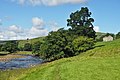
View from Nine Standards Rig over Westmorland to the Lake District
The quiet village of Keld in upper Swaledale is considered the middle of the path. Here the Pennine Way is crossed

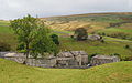
Former lead ore mine has devastated the landscape between Keld and Reeth
The alternative route through Swaledale is mostly on small footpaths

The flat Vale of Mowbray between the Pennines and the North York Moors is crossed in a 37 km stage

In agricultural regions, numerous farms offer accommodation or refreshments

A little north of Robin Hood's Bay, the route reaches the cliffs of the North Sea
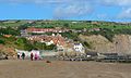
The goal: Robin Hood's Bay


literature
- Hiking guide
- Alfred Wainwright: A Coast to Coast Walk. A Pictorial Guide. Revised original description, partly out of date. Michael Joseph London 1974, ISBN 0-7181-4072-9
- Henry Stedman: Coast to Coast Path . 5th edition 2012 from the Trailblazer series, ISBN 978-1-905864-47-8 . Exact and very detailed route description with alternatives, 258 pages
- Martin Wainwright: A Coast to Coast Walk. Aurum Press Verlag, ISBN 978-1-845-13222-4 . Path noted on Ordnance Survey cards.
- Reports
- Erik Lorenz: Through the heart of England. Step by step from coast to coast. Wiesenburg Verlag 2014, ISBN 3956321049 . Detailed experience report with color photos, 372 pages
- Olivia Portmann: Getting closer. My way from coast to coast. Brunner Verlag Kriens 2011, ISBN 978-3-03727-039-4 . English and German.
Web links
Individual evidence
- ↑ according to the imprint in the book; first published in the Westmorland Gazette
- ↑ Wainwright incorrectly assumed in some sections that the land was freely accessible; the necessary permits from the landowners were obtained later
- ^ Wainwright in the foreword, p. vi: The route given in this book makes no attempt to follow a straight line: deviations are necessary throughout, primarily to avoid private ground but additionally to take the opportunity of visiting places of special interest nearby - without ever losing sight of the final objective.
- ↑ BRouter by Arndt Brenschede , accessed on March 12, 2018.
- ↑ http://news.bbc.co.uk/1/hi/england/4034485.stm